The India Climate Observatory

Commentary, action and research on climate and development in India

  • Home
  • About
  • Monsoon 2018
  • Current
  • Bulletin
  • Contact
  • Announcements

From space, a district and its water

October 9, 2015 by Climate portal editor 3 Comments

RG_ICP_water_district_map_201510

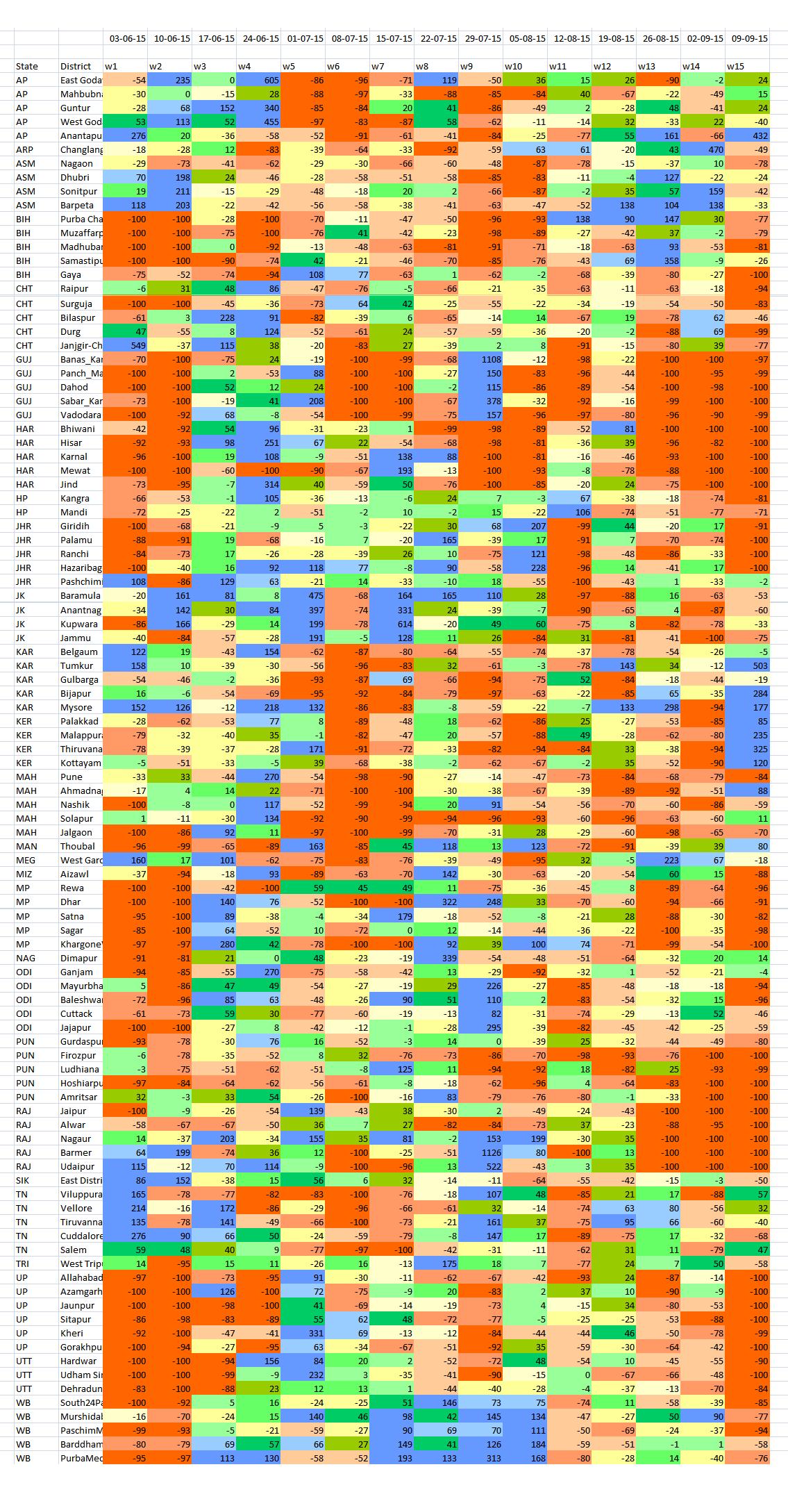
In this panel of maps the relationship between the district of Parbhani (in the Marathwada region of Maharashtra) and water is graphically depicted over time. The blue squares are water bodies, as seen by a satellite equipped to do so. The intensity of the blue colour denotes how much water is standing in that coloured square by volume – the deeper the blue, the more the water.

Water bodies consist of all surface water bodies and these are: reservoirs, irrigation tanks, lakes, ponds, and rivers or streams. There will be variation in the spatial dimensions of these water bodies depending on how much rainfall the district has recorded, and how the collected water has been used during the season and year. In addition to these surface water bodies, there are other areas representing water surface that may appear, such as due to flood inundations, depressions in flood plains, standing water in rice crop areas during transplantation stages. Other than medium and large reservoirs, these water features are treated as seasonal and some may exist for only a few weeks.

RG_ICP_water_district_map_201510_section

Click for a section of the full size image. The detail can be mapped to panchayat level.

The importance of monitoring water collection and use at this scale can be illustrated through a very brief outline of Parbhani. The district has 830 inhabited villages distributed through nine tehsils that together occupy 6,214 square kilometres, eight towns, 359,784 households in which a population of 1.83 million live (1.26 rural and 0.56 million urban). This population includes 317,000 agricultural labourers and 295,000 cultivators – thus water use and rainfall is of very great importance for this district, and indeed for the many like it all over India.

This water bodies map for Parbhani district is composed of 18 panels that are identical spatially – that is, centred on the district – and display the chronological progression of water accumulation or withdrawal. Each panel is a 15-day period, and the series of mapped fortnights begins on 1 January 2015.

The panels tell us that there are periods before the typical monsoon season (1 June to 30 September) when the accumulation of water in surface water bodies has been more than those 15-day periods found during the monsoon season. See in particular the first and second fortnights of March, and the first fortnight of April.

During the monsoon months, it is only the two fortnights of June in which the accumulation of water in the surface water bodies of Parbhani district can be seen. The first half of July and the second half of August in particular have been recorded as relatively dry.

This small demonstration of the value of such information, provided at no cost and placed in the public domain, is based on the programme ‘Satellite derived Information on Water Bodies Area (WBA) and Water Bodies Fraction (WBF)’ which is provided by the National Remote Sensing Centre (NRSC), Indian Space Research Organisation (ISRO), Department of Space, Government of India.

For any of our districts, such continuous monitoring is an invaluable aid to: facilitate the study of water surface dynamics in river basins and watersheds; analyse the relationships between regional rainfall scenarios and the collection and utilisation of water in major, medium reservoirs and irrigation tanks and ponds; inventory, map and administer the use of surface water area at frequent intervals, especially during the crop calendar applicable to district and agro-ecological zones.

Filed Under: Blogs, Monsoon 2015 Tagged With: agriculture, district, ISRO, Maharashtra, monsoon, NRSC, rain, remote sensing, reservoir, river, rural, space, town, urban, village, water

Where they waited for rain in 2015

September 18, 2015 by Climate portal editor 1 Comment

RG_ICP_20150918

With two weeks of the June to September monsoon remaining in 2015, one of the end-of-season conclusions that the India Meteorological Department (IMD) has spoken of is that four out of ten districts in the country has had less rainfall than normal.

This overview is by itself alarming, but does not aid state governments and especially line ministries plan for coming months, particularly for agriculture and cultivation needs, water use, the mobilisation of resources for contingency measures, and to review the short- and medium-term objectives of development programmes.

RG_ICP_100districts_table_20150918The detailed tabulation provided here is meant to provide guidance of where this may be done immediately – in the next two to four weeks – and how this can be done in future.

The table lists 100 districts each of which have readings 15 weeks of rainfall variation – the numbers are not rainfall in millimetres (mm) but the variation in per cent from the long-term normal for that district for that week. The colour codes for each district’s week cell are the same as those used for the new 11-grade rainfall categorisation.

The districts are chosen on the basis of the size of their rural populations (calculated for 2015). Thus Purba Champaran in Bihar, Bhiwani in Haryana, Rewa in Madhya Pradesh and Viluppuram in Tamil Nadu are the districts in those states with the largest rural populations.

In this way, the effect of rainfall variability, from Week 1 (which ended on 3 June) to Week 15 (which ended on 9 September), in the districts with the largest rural populations can be analysed. Because a large rural population is also a large agricultural population, the overall seasonal impact on that district’s agricultural output can also be inferred.

The distribution of the districts is: six from Uttar Pradesh; five each from Andhra Pradesh, Bihar, Chhattisgarh, Gujarat, Haryana, Jharkhand, Karnataka, Maharashtra, Madhya Pradesh, Odisha, Punjab, Rajasthan, Tamil Nadu and West Bengal; four each from Assam, Jammu and Kashmir, and Kerala; three from Uttarakhand; two from Himachal Pradesh; one each from Arunachal Pradesh, Manipur, Meghalaya, Mizoram, Nagaland, Sikkim and Tripura.

Using the new 11-grade rainfall categorisation, a normal rainweek is one in which the rainfall is between +10% more and -10% less for that week. The overview for this group of 100 districts, only 11 have had five or more normal weeks of rain out of 15 weeks. In alarming contrast, there are 77 districts which have had three or fewer normal weeks of rain – that is, more than three-fourths of these most populous districts. Half the number (51 districts) have had two, one or no normal weeks of rain. And 22 of these districts have had only one or no normal weeks of rain.

From this group of 100 most populous (rural population) districts Gorakhpur in Uttar Pradesh and Nagaon in Assam have had the most deficit rainweeks, tallying 13, out of the 15 tabulated so far. There are ten districts which have had 12 deficit rainweeks out of 15 and they are (in decreasing order of rural population): Muzaffarpur (Bihar), Pune and Jalgaon (Maharashtra), Surguja (Chhattisgarh), Panch Mahals and Vadodara (Gujarat), Firozpur (Punjab), Thiruvananthapuram (Kerala), Hoshiarpur (Punjab) and Mewat (Haryana).

– Rahul Goswami

Filed Under: Monsoon 2015, Reports & Comment Tagged With: agriculture, district, IMD, India, monsoon, population, rain, rural, urban, water

Lessons of monsoon 2015 for district India

September 16, 2015 by Climate portal editor 2 Comments

ICP_rainweek_commentary_20150916

By our conventional method of reckoning the adequacy of the 2015 monsoon, this is a year that is amongst the most deficient in rain over a period of 20 years. The monsoon season began late, compared with its usual onset, and apart from a few sustained heavy spells in a few locations, has been less than adequate and also less than normal in every one of our 36 meteorological sub-divisions.

When after eight weeks of the conventional monsoon season it became evident that a combination of factors was causing weak and erratic rainfall, that is when the central and state governments needed to place on alert the regions that were already facing rainfall deficits. At this point, when we have the evidence provided by data for 15 weeks of the monsoon season (until 9 September), every week from early August onwards that passed without such a declaration is a week of preparation and coping lost.

In this commentary, I have described the advantages of using a new methodology that grades rainfall adequacy at the level of the district, to a degree that is very much finer than the five categories of the India Meteorological Department (IMD), which are: normal, excess, deficient, scanty and no rain. The outputs from this methodology (illustrated and described here) are designed to: (1) alert national food and agriculture administrators to impending food insecurity conditions; (2) alert national water resources administrators to impending water scarcities; (3) alert line departments of state ministries and district collectorates to the build up of climatological distress at the district level so that contingency measures can be taken.

RG_2015_rainweek_graphic3Over the conventional season (1 June to 30 September) the inadequacy of rainfall in 2015 is revealed at a glance by the weekly rain report. It makes for a very alarming picture and shows that state administrations and especially district authorities should, by the sixth week which ended on 8 July, have made arrangements to prepare for below-normal rains. In the weekly rain report, each vertical bar corresponds to a week of districts categorised into eleven grades. This provides a weekly national barometer of the number of districts that are in the lower and upper (severely below and above normal rainfall) categories during a given week.

Such a weekly rainfall adequacy report is able to quickly put a stop to the recent tendency of administrations, the media and all those who must manage natural resources (particularly our farmers), to think in terms of an overall seasonal ‘deficit’ or an overall seasonal ‘surplus’. This ‘seasonal’ view must be abandoned because demands for water are not cumulative – they are made several times a day, and become more or less intense according to a cropping calendar, which in turn is influenced by the characteristics of a river basin and of a corresponding agro-ecological zone, and the rural and urban populations in a district.

The difference between the IMD five-grade assessment and the eleven-grade categorisation of rainfall becomes immediately apparent when a comparison is made for any given week. The data source is the same – the weekly tabulation compiled by the IMD’s Hydromet Division (which from this monsoon season provides the data sheets and detailed maps on its ‘customised rainfall information system’, or CRIS, website).

RG_ICP_grade_systems_comparedWeek 11 of the monsoon season, which is the week until 12 August, provides such an example. Under the five-grade IMD scale, there were 114 districts with normal rain (from -19% to +19%). Under the 11-grade new categorisation, the middle grade is -10% to +10%, and included 66 districts. Under the five-grade IMD scale districts with below normal rainfall fall under deficient (-20% to -59%) or under scanty (-60% to -99%) and for this week the number of districts respectively were 155 and 223. Under the 11-grade new categorisation, there are four grades for below-normal rainfall that is -20%.

Thus while the ‘deficient’ grade includes 155 districts, under the 11-grade system there are 150 districts distributed between two grades – 84 and 66, but we see that a larger number of districts fall in the more severe of the two grades. The signal to be derived from this, at the state and districts administration level, is that if a district remains for two to three weeks at a grade, then contingency measures must be reviewed, readied or rolled out. This is a decision that becomes considerably easier with the 11-grade system when compared with the existing five-grade system.

In the same way, the week by week tabulation of districts under the 11-grade system reveals trends and patterns that are not visible under the existing IMD five-grade assessment. The table shows the distribution of districts by grade across weeks. In each week, the two grades that account for the largest number of districts are highlighted red. We see that for the the first five rain weeks – week ending 3 June to week ending 1 July – the +81% and above grade was one of the top two populated grades. This occurred once more for Week 7, ending 15 July. For the next eight rain weeks – ending 22 July to ending 9 September – the top two populated grades have been in the rainfall grades of -41% to -60%, -61% to -80% and -81% and less. At the country level, this starkly underlines the seriousness of the rainfall deficit.

RG_ICP_weekly_tableThe uses to which we have put available climatic observations no longer suit an India which is learning to identify the impacts of climate change. Until 2002, the monsoon season was June to September, there was an assessment in May of how well (or not) the monsoon could turn out.

The India Meteorology Department has added computational and analytical resources furiously over the last decade. The new research and observational depth is complemented by the efforts of a Ministry of Earth Sciences which has channelled the copious output from our weather satellites, under the Indian Space Research Organisation (ISRO), and which is interpreted by the National Remote Sensing Centre (NRSC), to serve meteorological needs.

The IMD, with 559 surface observatories, 100 Insat satellite-based data collection platforms, an ‘integrated agro-advisory service of India’ which has provided district-level forecasts since 2008, a High Performance Computing System commissioned in 2010 (whose servers run at Pune, Kolkata, Chennai, Mumbai, Guwahati, Nagpur, Ahmedabad, Bengaluru, Chandigarh, Bhubaneswar, Hyderabad and New Delhi) intelligently consumes an astonishing amount of numerical data every hour.

Over the last four years, more climate and weather ‘products’ (as the IMD system calls them) based on this data and their interpretations have been released via the internet into the public domain. These are reliable, timely (some observation series have even three-hour intervals), and valuable for citizen and administrator alike.

Even so, the IMD’s framing of how its most popular measures are categorised is no longer capable of describing what rain – or the absence of rain – affects our districts. These popular measures are distributed every day, weekly and monthly in the form of ‘departures from normal’ tables, charts and maps. The rain adequacy categories are meant to guide alerts and advisories.

These number four: ‘normal’ is rainfall up to +19% above a given period’s average and also down to -19% from that same average, ‘excess’ is +20% rain and more, ‘deficient’ is -20% to -59%, ‘scanty’ is -60% to -99%, and ‘no rain’ is -100%. These categories can mislead more than they inform, for the difference between an excess of +21% and an excess of +41% can be the difference between water enough to puddle rice fields and a river breaking its banks to ruin those fields.

In today’s concerns that have to do with the impacts of climate change, with the increasing variability of the monsoon season, and especially with the production of food crops, the IMD’s stock measurement ‘product’ is no longer viable. It ought to have been replaced at least a decade ago, for the IMD’s Hydromet Division maintains weekly data by meteorological sub-division and by district. This series of running records compares any given monsoon week’s rainfall, in a district, with the long period average (a 50-year period). Such fineness of detail must be matched by a measuring range-finder with appropriate  interpretive indicators. That is why the ‘no rain’, ‘scanty’, ‘deficient’, ‘normal’ or ‘excess’ group of legacy measures must now be replaced. In its place an indicator of eleven grades translates the trends, patterns and messages in IMD’s district-level rainfall data into meaningful and actionable signals.

– Rahul Goswami

Notes

The new 11-grade indicator for assessing weekly rainfall departures in districts uses the same data IMD releases into the public domain, but provides dramatically more useful guidance. This yields the detailed reading required to alert state administrations to drought, drought-like and potential flood conditions. The modified methodology adapts the UN Food and Agriculture Organisation’s ‘Global Information and Early Warning System’ employment of 11 grades.

The weekly tallies of rainfall distribution for meteorological sub-divisions and for states are no longer able to signal administrative action and must be replaced with district-scale and (by 2016 monsoon) urban-scale assessments. The ability of the new 11-grade methodology to provide early warnings of climatic trauma in districts is now clear, and state administrations can respond to growing climatological distress in a targeted manner. Districts and blocks need to be supplied rainfall trends – and not only distribution data – that help farmers and administrators alike better plan for rainfall variability.

Filed Under: Current, Monsoon 2015 Tagged With: 2015, agriculture, district, India, monsoon, rain, water

Being prudent about forecasts

June 3, 2015 by Climate portal editor Leave a Comment

ICP_pre-monsoon_seasons_2011-15_sm

The Earth System Science Organisation (ESSO), Ministry of Earth Sciences (MoES) and the India Meteorological Department (IMD) released their second long range forecast for monsoon 2015 on 2 June. The ‘headline’ message is that rainfall for the June to September monsoon season is very likely to be 88% of what is normal for the season.

The forecast has been seized upon by various quarters as having serious implications for the production of crop staples (and therefore for food security), for farmers’ livelihoods, for consumer prices and for the availability of water. These are all valid and important aspects that depend entirely or substantially upon the summer monsoon.

But, the IMD, the ESSO and the MoES do not make statements and forecasts on these aspects. They are concerned with what the climatological data and signs point to, and that is what they have told us. How the forecast relates to important aspects of food, farm incomes, water resources and food stocks relies on interpretations. Our advice – to the media, to government agencies and to the private sector – is to go slow on drawing conclusions and when conclusions are required, to make them incrementally.

The wettest pre-monsoon season (March to May) for five years.

The wettest pre-monsoon season (March to May) for five years.

Using the handy graphic here, (887KB) we also point out that the pre-monsoon season (March to May) for 2015 has been the wettest in five years. In several meteorological sub-divisions, excess rain has been recorded during this pre-monsoon season. In several districts, the annual rainfall total has already been reached, even before the typical monsoon season of June to September.

This ought to be warning enough to us to be sparing with deciding how forecasts will affect us. The ESSO, IMD and MoES have repeated, in their second long range forecast, that 2015 is an El Niño year which only means that as this sea temperature phenomenon waxes and wanes though the remainder of 2015, so too will the monsoon system react.

It is best to judge our Indian summer monsoon a week at a time, keeping in mind crop calendars and how much water our reservoirs hold. It is always prudent to take precautions such as rationing water (even when it is raining), especially in towns and cities. Likewise, district administrations will do well to assess their local supplies of food staples and match these figures with what food staples their districts are likely to produce during a monsoon whose reliability has now been written off.

The second long range forecast for monsoon 2015 is available here, and the Hindi text can be found here.

Filed Under: Monsoon 2015, Reports & Comment Tagged With: 2015, climate, consumer price, crop, El Nino, farm, food stock, forecast, IMD, India, meteorology, monsoon, sea surface temperature, water

A report card on monsoon 2014

October 1, 2014 by Climate portal editor Leave a Comment

RG_ICP_districts_table_201410
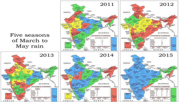
From the first week of June 2014 until the middle of September 2014, there have been floods and conditions equivalent to drought in many districts, and for India the tale of monsoon 2014 comes from a reading of individual districts, not from a national ‘average’ or a ‘cumulative’. [This article was published by the newspaper DNA.]

Despite the advances made by our agencies in weather forecasting and climate monitoring, the science of meteorology still remains to be effectively distilled so that it can be used by citizens and, wherever possible, expanded and given context by ground-based observation and recording. One sector in which this does take place – albeit at a level still far below its potential – is agriculture. The reason is clear: our crop staples (the cereals, pulses, vegetables and fruit) have their individual calendars for preparation, sowing, tending and harvesting.

This line chart tells some of the tale. It shows that for the first six weeks of monsoon 2014, most districts recorded rain below their 'normals' for those weeks. The lines are percentile lines; they tell us what percent of districts recorded how much rainfall in a monsoon week relative to their normals for that week. This chart does not show how much rain - it shows distance away from a weekly normal for districts. The left scale is a percentage - higher percentages indicate how far above normal districts recorded their rainfall, negative numbers show us how far below normal their rainfall was. The dates (the bottom scale) are for weeks ending on that date for which normals and departures from normal were recorded. The P_01 to P_09 lines are the percentiles (10th to 90th) of all districts in every week.

This line chart tells some of the tale. It shows that for the first six weeks of monsoon 2014, most districts recorded rain below their ‘normals’ for those weeks. The lines are percentile lines; they tell us what percent of districts recorded how much rainfall in a monsoon week relative to their normals for that week. This chart does not show how much rain – it shows distance away from a weekly normal for districts.
The left scale is a percentage – higher percentages indicate how far above normal districts recorded their rainfall, negative numbers show us how far below normal their rainfall was. The dates (the bottom scale) are for weeks ending on that date for which normals and departures from normal were recorded. The P_01 to P_09 lines are the percentiles (10th to 90th) of all districts in every week.

And so we have an agricultural meteorology system that faithfully and reliably informs ‘kisans’ and cultivators in 641 districts what to expect from the weather for the next week. Thanks to mobile phones, weather alerts and crop advisories are distributed in all our major languages to a portion of the farming households working on 138 million farm holdings, (of which 117 million are small). But this is still only a portion, and is far from adequate in distributing the results of the work of our earth scientists and field staff.

Moreover, every other sector of development requires such raw data and location-specific analysis: the Department of Rural Development, the National Rural Health Mission, the Nirmal Bharat Abhiyan (for drinking water and sanitation), the food-based programmes (like the mid-day meals) for which the availability of ingredients and their supply is the essence of their work, the Central Water Commission and the Central Ground Water Board, whose work it is to determine the water flows and balances in river sub-basins and watersheds (there are 3,257), and districts administrations (which administer 232,855 panchayats) and municipal councils alike which must implement relief measures when drought sets in or must ration supply when there are shortages. This is but a small list of agencies whose work is directly affected by the Indian summer monsoon and its activity where they work.

A dense network of weather stations (more of these are being automated every month, but every taluka still does not have one) is complemented by dedicated satellites which provides continuous coverage of the sub-continent, the northern Asian land mass, the surrounding oceans southwards until beyond the Tropic of Capricorn.

The typical IMD map of 'normal' rainfall measured by the meteorological sub-divisions. The detailed weekly tables give us a very different picture

The typical IMD map of ‘normal’ rainfall measured by the meteorological sub-divisions. The detailed weekly tables give us a very different picture

Methods to simply and accurately funnel this stream of real-time data and imagery are available, mostly at no cost, in order to aid local administrations, farmers and cultivators, and all citizens. It is this availability and relative simplicity of use (block-level weather forecasts for 72 hours are now available as local language apps on smartphones) that must be encouraged by the official agencies – for they simply do not have the persons to do so at the scale and detail required.

Consider the setting in early July 2014. India’s summer monsoon was already late, and where it was late but active it was weak (as shown by the chart). The indications from the central earth science agencies (including the India Meteorological Department), from the Indian Institute of Tropical Meteorology, from the National Centre for Medium Range Weather Forecasting were that it would be end-June before the summer monsoon system settles over central India and the western Gangetic plains. This did not happen for another two weeks, until six of the usual 16 monsoon weeks had passed.

When in mid-July more rainfall was recorded in the districts, even then, as the chart shows, only 50% of the districts reached their ‘normals’ for that week only. Thereafter, the volatility of rainfall set in and while for those in our towns and cities there was relief from the searing summer temperatures the rains did not assure sowing conditions for farmers and cultivators, nor did it add, in July, to the stores of water in major and minor reservoirs.

That is why the IMD’s outdated and stodgy public outreach practice must be overhauled, completely. The bland map (see example) of sub-divisions is of little use when what we want to know pertains to tehsil and town. The Met Department’s rain adequacy categories must be replaced too by measures that are geared towards aiding alerts and advisories – ‘normal’ is rainfall up to +19% above a given period’s average and also down to -19% from that same average, a range that can make or break the efforts of a horticulturist.

This table illustrates the trend of weekly rainfall in 40 districts. These districts are selected as being home to the largest rural populations, two from the 20 major states (by population). The numbers by week and district describe how far from a 'normal' the recorded rainfall for that week was. Several overall observations stand out. Districts with weeks coloured light rose dominate, for these show those that received much less rain than they should have. Districts with a shade of deeper blue are the next most frequent category, and those received excess rain. Taken together, this tells us that extremes - very much less or more - were common for this group of districts in India with large rural populations. We can see the prolonged dry spells for districts in Haryana and Punjab; likewise the absence of rain for the first six monsoon weeks in Gujarat and Maharashtra; are examples of wide swings around weekly 'normal' in Giridih (Jharkhand), Muzaffarpur (Bihar), Haridwar (Uttarakhand), Mandi (Himachal Pradesh), Viluppuram (Tamil Nadu), and Mahbubnagar (Andhra Pradesh). The weeks ending 20 August in Bihar and the weeks ending September 3 and 10 in Jammu and Kashmir immediately stand out - the Kosi had breached its banks in Bihar and the Chenab submerged Srinagar and Jammu.

This table illustrates the trend of weekly rainfall in 40 districts. These districts are selected as being home to the largest rural populations, two from the 20 major states (by population). The numbers by week and district describe how far from a ‘normal’ the recorded rainfall for that week was.
Several overall observations stand out. Districts with weeks coloured light rose dominate, for these show those that received much less rain than they should have. Districts with a shade of deeper blue are the next most frequent category, and those received excess rain. Taken together, this tells us that extremes – very much less or more – were common for this group of districts in India with large rural populations.
We can see the prolonged dry spells for districts in Haryana and Punjab; likewise the absence of rain for the first six monsoon weeks in Gujarat and Maharashtra; are examples of wide swings around weekly ‘normal’ in Giridih (Jharkhand), Muzaffarpur (Bihar), Haridwar (Uttarakhand), Mandi (Himachal Pradesh), Viluppuram (Tamil Nadu), and Mahbubnagar (Andhra Pradesh). The weeks ending 20 August in Bihar and the weeks ending September 3 and 10 in Jammu and Kashmir immediately stand out – the Kosi had breached its banks in Bihar and the Chenab submerged Srinagar and Jammu.

Likewise, excess is +20% and more, deficient is -20% to -59% and scanty is -60% to -99%. To illustrate how misleading these categories can be, the difference between an excess of +21% and +41% can be the difference between water enough to puddle rice fields and a river breaking its banks to ruin those fields. [Get a full resolution image of the table here, 1.85 MB.]

The yawning gap between the technical competence of India’s climate monitoring systems, and they ways in which they are used, must be bridged and this is best done through public participation and citizen initiative. The politics of monsoon and of water will continue, but must not be allowed to define how our systems are used. Nor must they detract from our long history of weather observation, which dates back at least to the ‘Vrhat Sanhita’ of Varahamihira.

It has only signalled policy confusion for central and state governments to have not declared districts and talukas as affected by drought – which they should have by late July 2014 – while at the same time quietly announcing to administrations, as the Ministry of Agriculture did, that “to deal with challenges posed by delayed and aberrant monsoon and in the wake of shortfall in sowing of major crops during kharif 2014, the government has initiated interventions”. These being a diesel subsidy for what is called ‘protective irrigation’ of crops, raising the ceiling on the seed subsidy, rolling out a drought mitigating programme for horticulture, boosting fodder cultivation through the flagship Rashtriya Krishi Vikas Yojana.

The new government has stated time and again its desire to improve and strengthen governance. This must come to include a concerted drive to democratise the use of public domain information, including our monsoon and water, in order that we residents of 4,041 statutory towns (large cities included) and 3,894 census towns can judge for ourselves the relationships between the food we buy, they rain we receive, our individual use of about 70 litres of water a day, and the fluctuation of these trends from one monsoon to another. The moral of monsoon 2014 is that we must reclaim local measures for local use.

Rahul Goswami

Filed Under: Latest, Monsoon 2014 Tagged With: 2014, administration, agriculture, crop, district, ground water, health, IMD, India, krishi, meteorology, monsoon, policy, remote sensing, river, sanitation, smartphone, varahamihira, vrhat samhita, water, watershed, weather station

The IMD’s shaky monsoon math

August 7, 2014 by Climate portal editor Leave a Comment

RG_ICP_pic_20140806

Over eight weeks of recorded monsoon rain, the district-level data available with the India Meteorological Department (IMD) portrays a picture that is very different from its ‘national’ and ‘regional’ advice about the strength and consistency of rainfall.

In its first weekly briefing on the monsoon of August 2014, IMD said: “For the country as a whole, cumulative rainfall during this year’s monsoon (01 June to 30 July 2014) has so far upto 30 July been 23% below the Long Period Average.” Out of 36 meteorological sub-divisions, said the IMD, the rainfall has been normal over 15 and deficient over 21 sub-divisions.

Readings for each district that has reported rainfall consistently for eight weeks. The columns represent the percentage value of actual rainfall for each district against their normal rainfall for eight weeks.

Readings for each district that has reported rainfall consistently for eight weeks. The columns represent the percentage value of actual rainfall for each district against their normal rainfall for eight weeks.

However, we have compiled a far more realistic reading of the monsoon season so far, from the IMD’s own data. For the 614 individual readings from districts that have regular rainfall readings, we have the following: 86 districts have registered scanty rainfall (-99% to -60%); 281 districts have registered deficient rainfall (-59% to -20%); 200 districts have registered normal rainfall (-19% to +19%); and 47 districts have registered excess rainfall (+20% and more).

Moreover, using our running weekly district-level monsoon meter – the details of which and the reasoning for which you will find in here – we see that there was a substantial dip in the number of districts registering ‘deficient 2’ rainfall, which is less than 21% of the normal and lower, during the seventh week of rain, that is the week of 17 to 23 July. But the general trend returned the following week, 24 to 30 July.

What this means, and the bar chart we have provided to illustrate the 614 individual values leaves us in no doubt, is that 367 out of 614 districts have had meagre rain for eight weeks. This also means that over eight weeks where there should have been rainfall that – as the IMD predicted in early June – would be around 95% of the ‘long period average’, instead three out of five districts have had less than 80% of their usual quota.

Our running weekly district-level monsoon meter to aid governance decisions shows the overall trend has not changed substantially in the last fortnight despite good rains during the seventh monsoon week.

Our running weekly district-level monsoon meter to aid governance decisions shows the overall trend has not changed substantially in the last fortnight despite good rains during the seventh monsoon week.

Unfortunately, the press and media – in particular the business and financial media – persist in reporting ‘national’ deficits and whether monsoon 2014 will ‘make up’ the average in the remaining period. This approach must be corrected by the IMD’s departmental divisions as it incorrectly makes popular the notion that total rainfall over a designated number of weeks is the most important monsoon metric (See ‘Why there is no ‘normal’ in our monsoon’). Of course it is not so, as different crops follow their own crop calendars according to the agro-ecological regions they are grown in, and require optimum rain at certain times during their respective crop calendars.

The following examples show why such reporting can be misleading:

From Reuters: “August rains hold the key to India’s major summer crops such as rice, soybean, cane and cotton, after a wet end to July failed to make up fully for a dry start to the four-month monsoon season. A late revival shrank the shortfall in rain to around 10 percent below average in July, the India Meteorological Department’s update showed on Thursday, a sharp improvement from the 43 percent deficit in the first month of the season.”

From Bloomberg: “Monsoon crops are sown from June and harvested from October. The country had less than 40 percent of average rains in the first six weeks of the monsoon season that runs through September. The shortage shrank to 23 percent by end-July. Oilseed planting in India is poised to slump as much as 24 percent to the lowest since 2002 after a weak start to the monsoon.”

From The Hindu: “With the country receiving good rain in July, monsoon deficiency has gone down to 23 percent, the MET department on Friday said. While the monsoon deficiency at the national level in June was 43 per cent, by July end it has come down to 23 per cent. Central India, which saw little rain in June, has by now seen some good rain. It received 402.2 mm of rainfall as compared to expected rainfall of 477.7 mm with a deficiency of 16 per cent, much lesser compared to other parts of the country.”

From Business Standard: “According to the India Meteorological Department (IMD), the rains managed to recoup much of the June losses due to strong revival over the central and western regions, and parts of northern India. Weather officials said the momentum of July would continue till about August 10 and then slacken a bit.”

From Mint: “India’s July rain deficit narrowed to 10% of the long-term average for the month, marking a recovery from the driest June in five years, the India Meteorological Department (IMD) said, as kharif crop sowing picked up in tandem. The shrinking of the rainfall deficit in July comes at a time when policymakers have been concerned about the impact of a below-average monsoon on foodgrain production and inflation. The June-September monsoon accounts for more than 70% of the annual rainfall in India and irrigates crops grown on half the country’s farmlands.”

Filed Under: Blogs, Current, Monsoon 2014 Tagged With: 2014, agriculture, climate, crop, district, food, foodgrain, IMD, India, inflation, irrigation, kharif, meteorology, monsoon, rainfall, water

Deadly negligence

August 4, 2014 by Climate portal editor Leave a Comment

A resident looks at the debris of her damaged house after a landslide at Malin village, Pune district, in Maharashtra on 30 July 2014. Photo: Reuters/Stringer

A resident looks at the debris of her damaged house after a landslide at Malin village, Pune district, in Maharashtra on 30 July 2014. Photo: Reuters/Stringer

Two months of monsoon that have delivered rainfall considerably below normal have given way to an end July and early August that has brought torrents of rain in some locations, and with it destruction and the loss of life.

In the last week, there has been a landslide in the Pune district, western Maharashtra, in which the death toll has risen to over 100. There has been a landslide in Nepal, along the Bhote Kosi river, around 120 kilometres from Kathmandu, which is reported to have killed over 100 and displaced thousands. The situation there has led to an emergency in north Bihar, through which the Kosi flows, with some 65,000 people being evacuated from nine districts.

In the Bay of Bengal, 40 trawlers are reported to have gone missing in bad weather; there are estimated to be some 650 fishermen on board the vessels. In the Munshiganj district of central Bangladesh, about 40 kilometres from Dhaka, a ferry on the Padma river sank with about 200 on board.

Every one of these events is repeated every monsoon – landslide, flood, river ferry sinking, fishing trawlers missing at sea – with little indication that learning takes place about how to contain the impacts and how to prepare for them when they become threats.

The threat from the Kosi developed after a massive landslide blocked the main course of Bhote Kosi river, a tributary of the Kosi, in Sindhupalchok district of Nepal. The landslide brought down rock which has dammed the river, immediately forming a large lake. Authorities in Nepal have been trying to release the water without endangering downstream regions.

The central government has said (o4 August Monday) that there is no immediate threat of a flood. India’s Home Ministry, the Nepal Water Commission, India’s Central Water Commission and India’s National Crisis Management Committee are coordinating preparations, relief and technical expertise. The Bihar state government is carrying our the evactuations to avoid a situation like 2008, when a breach in the Kosi embankment at Kushaha in Nepal caused one of the most devastating floods.

The landslide in Nepal and the emergency in downstream Bihar has again revived the debate as to whether a dam would help solve the problem of floods in north Bihar. Since 1945 there have been commissions to study the problem and make their recommendations, and proposed dams have been abandoned for compelling reasons – that the river valleys have unstable foundations, that the region is a high-risk seismic zone, that the reservoirs would silt up far sooner than expected, and that the costs would be prohibitive.

The tragic incidents in Maharashtra, in the Bay of Bengal, and in Munshiganj (Bangladesh) have much more to do with the wilful neglect of conditions that have built up a cumulative threat. The landslide in Pune district which has buried portions of a village, its residents and cattle, was according to a number of media reports the result of factors that included what appears to be no recognition of the most obvious risks. The hill above the village of Malin is reported to have been the site of wind turbines (which need heavy machinery to erect them) and also farming that used heavy equipment to level the top of the hill. Whichever factor is true, the use to which hill land was put was a threat to the settlement at its base, and little thought was given to monsoon conditions.

That such a large group of trawlers went missing in the Bay of Bengal near Kakdwip in South 24 Parganas district of West Bengal has to do with economic reasons, which media reports will at this stage not uncover. Three of the trawlers are reported as having capsized and authorities in West Bengal are said to have ‘traced’ 25 of the vessels. The question is: when squally weather and forecasts of heavy rain trigger warning to fishermen, why do they ignore these warnings and risk their lives? The usual answer is loan economics, for the trawler owners can’t afford delays in servicing the loans with which they bought the vessels, and are under pressure to find and sell fish, which is when safety considerations are ignored.

Similar considerations lead in Bangladesh to riverine ferries – a common mode of transport in great deltas – being overloaded to far beyond their capacities. The monsoon brings with it weather conditions that demand safety first, but when economic desperation and plain greed set in, elementary precautions that are meant to save lives are discarded.

Filed Under: Latest, Monsoon 2014 Tagged With: Bangladesh, Bay of Bengal, Bihar, cyclone, disaster, evacuation, ferry, fishermen, flood, India, Kosi, land use, landslide, Maharashtra, monsoon, Nepal, rehabilitation, rescue, water

Seeing the local in six rain weeks

July 23, 2014 by Climate portal editor Leave a Comment

RG_ICP_20140723_pic
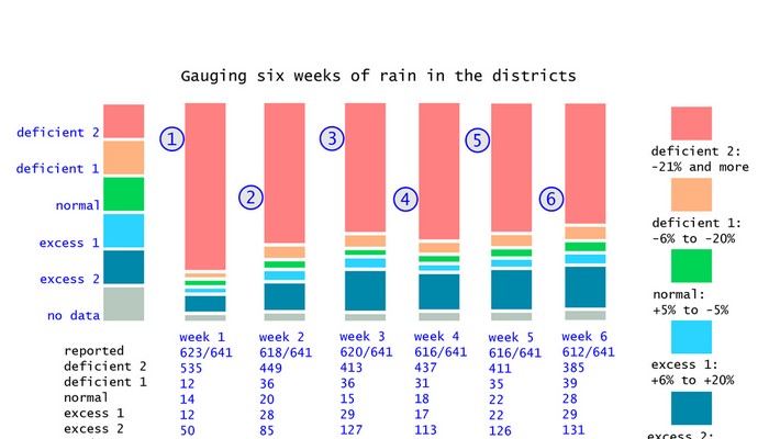
We urge the Ministry of Earth Sciences, the India Meteorology Department and the Ministry of Information and Broadcasting to cease the use of a ‘national’ rainfall average to describe the progress of monsoon 2014. This is a measure that has no meaning for cultivators in any of our agro-ecological zones, and has no meaning for any individual taluka or tehsil in the 36 meteorological sub-divisions. What we need to see urgently adopted is a realistic overview that numerically and graphically explains the situation, at as granular a level as possible.

Using a revised categorisation of rainfall sufficiency levels (the method and the reasoning is available here) we find that for the fifth and sixth weeks of monsoon, there has been a small improvement which does not lower the high likelihood of drought conditions becoming prevalent in districts and scarcity of water for our settlements. The full-size chart is available here as an image, and explains in detail the rainfall that districts are reporting.

The fifth monsoon week is 03 to 09 July 2014 and the sixth monsoon week is 10 to 16 July 2014. There has been a small addition to the revised normal rainfall category (-5% to +5%), rising from 18 districts recording normal rainfall in the 4th week to 22 in the 5th and 28 in the 6th. There has also been an improvement in the number of districts recording deficit-2 levels of rainfall (-21% and more) with 437 in the 4th week, 411 in the 5th week and 385 in the 6th week. For the remainder of July the likelihood of more rainfall in the districts that have recorded normal or excess-1 (+6% to +20%) is small, according to the available forecasts, and this means that monsoon 2014 will begin August with far fewer districts registering normal rainfall than they should at this stage.

Filed Under: Current, Monsoon 2014 Tagged With: 2014, agriculture, crop, deficient, district, drought, monsoon, normal, rainfall, scanty, scarce, sowing, water

India Climate Watch bulletin

July 2, 2014 by Climate portal editor Leave a Comment

ICW1_pic_for_ICP

The new government is speaking on climate change with confidence and purpose, and the administration of the Ministry of Environment, Forests and Climate Change is, like other line departments providing the public with more information and in greater detail. The new Indian Climate Watch bulletin has said, “Such an approach needs to be at least the minimum benchmark that ensures engagement and participation between government and citizens, government and industry, government and stakeholders who have not and continue not to find adequate representation when policy and planning id discussed and decided.” For this new and decisive direction, the bulletin added, the ministry under Prakash Javadekar deserves congratulations.

Download the India Climate Watch bulletin 2014 01 here (pdf, 122kb)

Download the India Climate Watch bulletin 2014 01 here (pdf, 122kb)

The new India Climate Watch bulletin has examined the recent statements made by the Ministry and provides an outline of the socio-economic contexts that must guide them. Several positives and points of concern are found:

  • The MoEF is functioning in a more transparent manner concerning climate change in India, and is discussing inter-governmental and multilateral meetings and conferences well ahead of time.
  • Javadekar is talking about finance, technology and time-tables pertaining to the international climate negotiations. He is also talking about a more active and larger role that India will play.
  • The MoEF is currently speaking on its own and the statements of the Government of India do not appear to reflect a common position held by key sectors such as agriculture and food, water resources, health, renewable energy, and petroleum.
  • The central government is discussing India’s international role in climate negotiations, in particular the Conference of Parties, CoP, that are held annually under the auspices of the United Nations Framework Convention on Climate Change (UNFCCC). There is scarce attention paid to climate change matters and responses in the states.

However, much more clarity is needed on the following points made by the central government through Javadekar and the MoEF. Read why in the India Climate Watch bulletin 2014 01 (pdf, 122kb).

Filed Under: India Climate Watch, Reports & Comment Tagged With: agriculture, bulletin, Climate Change, COP, food, health, ministry, MoEF, negotiations, sanitation, UNFCCC, water

  • « Previous Page
  • 1
  • 2

Indiaclimate twitter

Tweets by @Indiaclimate

Notable

Between contemplation and climate

Whether or not the USA, Europe, the Western world, the industrialised Eastern world (China, Japan, South Korea, Taiwan), adhere to or not their paltry promises about being more responsible concerning the factors that lead to climate change, is of very little concern to us. We have never set any store by international agreements on climate […]

The ‘Hindu’, ignorant about weather and climate, but runs down IMD

We find objectionable the report by ‘The Hindu’ daily newspaper accusing the India Meteorological Department of scientific shortcoming (‘IMD gets its August forecast wrong’, 1 September 2016). The report claims that the IMD in June 2016 had forecast that rains for August would be more than usual but that the recorded rain was less than […]

dialogue

  • Misreading monsoon | Resources Research on Misreading monsoon
  • Satish on A tribute to the weathermen of Bharat
  • Climate portal editor on A tribute to the weathermen of Bharat
  • Climate portal editor on A tribute to the weathermen of Bharat
  • Climate portal editor on A tribute to the weathermen of Bharat

Categories

Copyright © 2025 indiaclimateportal.org.