The India Climate Observatory

Commentary, action and research on climate and development in India

  • Home
  • About
  • Monsoon 2018
  • Current
  • Bulletin
  • Contact
  • Announcements

Two years of India’s weather watcher

July 28, 2015 by Climate portal editor Leave a Comment

ICP_insat3d_2years_sm_20150728

We wish Insat-3D a very happy second birthday and warmly congratulate the Indian Space Research Organisation (ISRO) on this anniversary.

Insat-3D completed two successful years in orbit on 26 July 2015. The Advanced Weather Satellite is designed for enhanced meteorological observations and monitoring of land and ocean surfaces for weather forecasting and disaster warning. Insat-3D is the first Indian geostationary satellite equipped with instruments that provide frequent good quality atmospheric profiles (temperature, humidity) over the Indian landmass and adjoining areas.

Thanks to the coordination between ISRO and the Indian Meteorological Department (IMD), we at India Climate Portal make heavy and frequent use of the many observational products, all free in the public domain, to inform you about weather and climate.

icp-insat3d-detailInsat-3D provides us high quality observations for monitoring and predicting of weather events as well as studying our climate. The advanced ‘Imager’ and ‘Sounder’ on the satellite provide a wide range of atmospheric products such as cloud coverage images, atmospheric winds, sea and land surface temperatures, humidity, quantitative rainfall, earth’s radiation, atmospheric profiles, ozone, atmospheric stability parameters, fog, snow, aerosols. These products are immensely helpful in monitoring day-to-day weather and prediction of extreme events like tropical cyclone, thunderstorm, cloud burst and heat waves.

The ‘Imager’ has completed 25,733 scans and ‘Sounder’ has completed 14,866 scans until the end of May 2015. The Insat-3D spacecraft was dedicated to the country at the National Satellite Meteorological Center (NCMC), India Meteorological Department (IMD), New Delhi on 15 January 2014. An indigenously designed and developed Insat-3D Meteorological Data Processing System processes all data transmitted by the Imager and Sounder. The data archival and dissemination is through IMD, New Delhi and the Meteorological and Oceanographic Satellite Data Archival Centre (MOSDAC, at Space Applications Centre, Ahmedabad).

A number of Insat-3D observations and derived products are being used in models operated by national weather prediction agencies like the IMD and the National Centre for Medium Range Weather Prediction (NCMRWF). Moreover, the European Centrer for Medium range Weather Forecast (ECMWF) and the United Kingdom Meteorological Office (UKMET) plan to use Insat-3D derived data in their global models.

As always, the ISRO family, staff, engineers, scientists and technicians excel at what they do best. In tandem with the committed and dilligent meteorologists of the IMD, they have given us free information, as good as the best the world can offer, so that we understand our Bharat better.

Filed Under: Current Tagged With: earth observation, earth science, forecast, India, insat, ISRO, satellite

Earth, sea, sky, El Niño

June 17, 2015 by Climate portal editor Leave a Comment

ICP_20150617_sm

Eight-and-a-half degrees north of the equator is where the peninsula of India meets the ocean. Our country stretches across 29 degrees of latitude but it is in the vast watery realm south of Kanyakumari that the Indian summer monsoon is brewed, slowly and inevitably. Over twice as many lines of latitude stretches the Indian Ocean, its equatorial belt and then its southern reaches, which continue into the deep and icy girdles of water around Antarctica.

From this vast aqueous quarter-planet the vapours are gathered, and these swirls of airborne water then look for the winds to transport them, first towards the mid-southern latitudes (Madagascar lies astride these, but they are are still a full ten degrees south of the lower coasts of Java) and then in the equatorial trough that spins like a motor. From here these enormous masses of water – half again the size of India at times – are hurled as if in slow motion towards our western coast.

And so to gauge imperfectly whether the wind lords of the farther Indian Ocean have decided to be kind to us we rely nowadays on our eyes in the sky, our weather satellites. What they tell us now is coded in electronic chirps made intelligible by the meteorologists and climatologists of the Indian Meteorological Department, the Ministry of Earth Sciences, the Indian Institute of Tropical Meteorology and the National Centre for Medium Range Weather Forecasting.

Our Indian summer monsoon is amongst the most complex of the planet’s earth-sea-sky interactions. We are told by the scientists, when they disengage from their equations, that the land retains a shorter climate ‘memory’ than the ocean. We are introduced to meridonal termperature gradients and seasonal migration of the inter-tropical convergence zone.

There is an abundance of exotic nomenclature: the Mascarene High, the orographic influence of the East African Highlands, the momentum of the Somali Jet, the ventilation effect of poleward precipitation. And then there is the hot star of the equatorial deeps, El Niño himself, whose domain is the central Pacific and who, when he awakes, demands that the equatorial Indian Ocean obey. He has awoken this year, but the ocean named after us is as unruly as ever.

When will El Niño’s whip really crack? The best models of the climate scientists cannot truly tell us. They and their teraflop calculating machines can only posit what is measured, and what remains unmeasured is still far greater. What we do however know about El Niño is that he does tend to suppress the monsoon. But this year’s El Niño may not resemble one of an earlier year, for where El Niño arises and rules is as important as when. Where the ocean surface warms up (several thousand kilometres parallel to the equator, several hundred kilometres wide) unusually strong rising air flows result.

When these flows descend (as they eventually must) they are generally dry and stable, and so the opposite of conditions needed for or monsoon rains. If they descend far away from India (as happened in 1997-98 when they dropped back into the eastern Pacific) our ocean will deliver and our monsoon will roll in. If they descend in the middle of the Pacific (which happened in 2002) our monsoon will resent the interference and hide. But El Niño is awake and pacing the Pacific. We must hope he does not look too far westwards. (RG)

Filed Under: Blogs, Monsoon 2015 Tagged With: Climate Change, earth science, El Nino, ENSO, India, Indian Ocean, monsoon, planet

It’s to be a 93% monsoon says the IMD

April 22, 2015 by Climate portal editor 1 Comment

RG_ICP_IMD_forecast_20150422

The India Meteorological Department has just released it’s long-awaited forecast for the 2015 Indian monsoon. In terms of the quantity of rainfall over the duration of the monsoon season (June to September) the IMD has said it will be 93% of the ‘Long Period Average’. This average is based on the years 1951-2000.

What this means is the ‘national’ average rainfall over the monsoon season for India is considered to be 89 centimetres, or 890 millimetres. So, based on the conditions calculated till today, the ‘national’ average rainfall for the June to September monsoon season is likely to be 830 millimetres.

There are caveats and conditions. The first is that the 93% forecast is to be applied to the long period average for each of the 36 meteorological sub-divisions, and a ‘national average’ does not in fact have much meaning without considerable localisation. The second is that the forecasting methodology itself comes with a plus-minus caution. There is “a model error of ± 5%” is the IMD’s caution.

This first forecast and the model that the forecast percentage has emerged from are thanks to the efforts of the Earth System Science Organization (ESSO), under the Ministry of Earth Sciences (MoES), and the India Meteorological Department (IMD), which is the principal government agency in all matters relating to meteorology. This is what the IMD calls a first-stage forecast.

IMD_categories_201504As with all complex models, this one comes with several considerations. The ESSO, through the Indian Institute of Tropical Meteorology (IITM, which is in Pune), also runs what it calls an ‘Experimental Coupled Dynamical Model Forecasting System’. According to this, the monsoon rainfall during the 2015 monsoon season (June to September) averaged over India “is likely to be 91% ±5% of long period model average”. (The IMD forecast is available here, and in Hindi here.)

This is a lower figure than the 93% headline issued by the IMD. This too should be read with care as there are five “category probability forecasts” that are calculated – deficient, below normal, normal, above normal and excess. Each is accompanied by a forecast probability and a climatological probability (see the table). The maximum forecast probability of 35% is for a below normal monsoon, while the maximum climatological probability is for a normal monsoon.

As before, time will tell and the IMD will issue its second long range forecast in June 2015. Our advice to the Ministry of Earth Sciences and to the IMD is to issue its second long range forecast a month from now, in May, and also to confirm these forecasts two months hence in June, when monsoon 2015 will hopefully be active all over the peninsula.

Filed Under: Monsoon 2015, Reports & Comment Tagged With: 2015, climate, climatology, earth science, ESSO, forecast, IMD, India, meteorology, monsoon, weather

Gauging four weeks of rain in the districts

July 8, 2014 by Climate portal editor Leave a Comment

ICP_four_weeks_rain_graphic_20140709

We now have rain data for four complete weeks from the India Meteorological Department (IMD) and for all the districts that have reported the progress of the monsoon. The overall picture is even more serious than reported earlier because of the falling levels of water in the country’s major reservoirs. [05 to 11 June is the first week. 12 to 18 June is the second week. 19 to 25 June is the third week. 26 June to 02 July is the fourth week.]

Using the new measure of assessing the adequacy of district rainfall (and not the meteorological gradations that is the IMD standard), in the fourth week of the monsoon the number of districts that reported normal rains in that week (+5% to -5%) is 16; deficient 1 (-6% to -20%) is 31; deficient 2 (-21% and more) is 437; excess 1 (+6% to +20%) is 17; excess 2 (+21% and more) is 113; no data was reported from 25.

Filed Under: Monsoon 2014, Reports & Comment Tagged With: 2014, contingency, district, drought, earth science, forecast, hydrology, IMD, India, monsoon, rainfall

The new measure of monsoon

June 20, 2014 by Climate portal editor 1 Comment

The changes that we find in the patterns, trends, intensity and quantity of India’s monsoon now require an overhaul in the way we assess what is satisfactory or not for environmental and human needs.

By Rahul Goswami

India’s summer monsoon is already late, and where it is late but active it is weak. The indications from the central earth science agencies (including the India Meteorological Department), from the Indian Institute of Tropical Meteorology, from the National Centre for Medium Range Weather Forecasting are that it will be the end of June before the summer monsoon system settles over central India and the western Gangetic plains. Even so, it will be a relief from the searing temperatures but will not assure sowing conditions for farmers and cultivators, nor will it add to the stores of water in major and minor reservoirs.

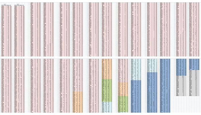
Districts reporting monsoon data, over two weeks, colour-coded under a revised categorisation (explained in the text) for weekly rainfall. The left bar in each pair is the second week, the right bar is the first. Most districts are coloured light red, signifying rainfall much below the weekly normal. Peach is for the lesser deficient category. Green is normal. The two blue hues - lighter and darker - are for the two excess categories. It is immediately apparent that 485 out of 618 reporting districts (78%) have experienced less rainfall than they should have at this stage of the monsoon.

Districts reporting monsoon data, over two weeks, colour-coded under a revised categorisation (explained in the text) for weekly rainfall. The left bar in each pair is the second week, the right bar is the first. Most districts are coloured light red, signifying rainfall much below the weekly normal. Peach is for the lesser deficient category. Green is normal. The two blue hues – lighter and darker – are for the two excess categories. It is immediately apparent that 485 out of 618 reporting districts (78%) have experienced less rainfall than they should have at this stage of the monsoon.

The situation is very much more worrying than it is presented as by the agencies and departments of the new NDA government, and by industry – which complains about duties and tariffs but pays no collective attention to the daily situation that attends the south-west monsoon. The Ministry of Agriculture has busied itself, since early 2014 May, with mentioning the new high of agricultural exports, with the apparent success of a new SMS service to farmers, with releasing the advance estimates for agricultural and horticultural production, with a review of the implementation of crop insurance schemes and there is one, only one, advisory issued for horticulture crop cultivators concerning what they must do “under the rain deficit conditions”.

Some of the problem – that is, an absence of urgency as the last week of June approaches with little evidence of the customary rains being deposited, and apparently little preparation for a deficit in rains – may be attributable to the manner in which basic rainfall data is assessed and distributed to the public. This is done by the IMD – and more recently by a new private sector that is exploiting the yawning gaps in data presentation and the delivery of timely forecasts.

It is however the IMD, the Ministry of Earth Sciences and the Department of Science and Technology that works with state government agencies and departments in the areas of water resources, agriculture and drinking water supply. With the enormous size of the constituencies that are affected by dwindling water supplies and late sowing, there is a very strong case for revising the terms with which rainfall is measured and the frequency with which forecasts are distributed to districts and settlements.

It is absurd that the primary indicator during the designated ‘monsoon months’, according to the IMD, which are June to September, is a weekly table and weekly map of sub-divisional rainfall. Such an approach is not only out of date in the very hour it is issued – and distributed via the media – it is also grossly negligent of the commendable and ubiquitous advances made by public sector science and private ingenuity alike concerning the handling and treatment of climatic and weather-related data for India.

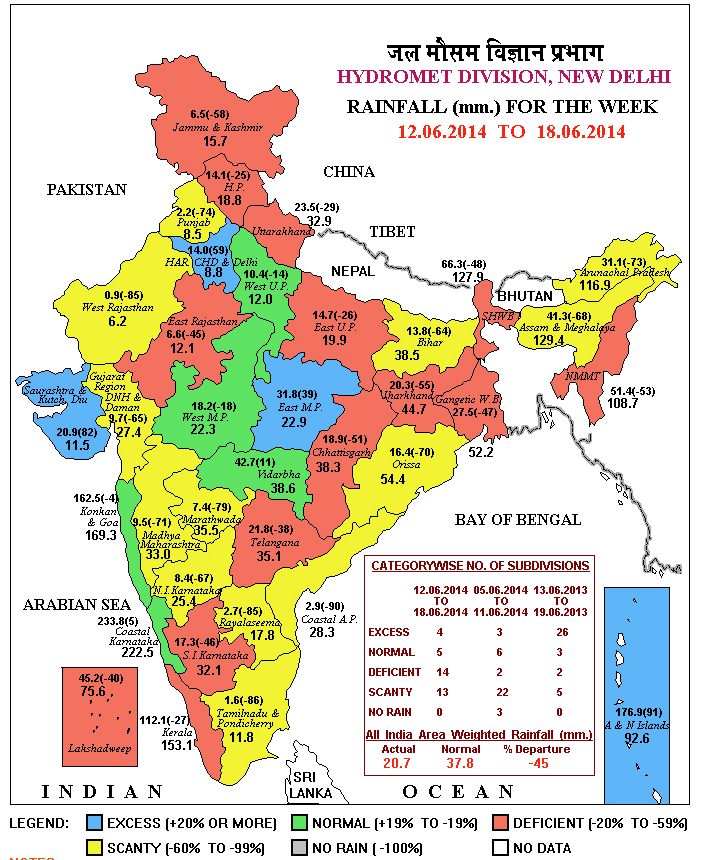
The typical IMD weekly rain map showing the colour codes and data for India's 36 meteorological subdivisions. This presentation urgently needs to be retired in favour of a more granular (district) map that is updated as soon as new data is received.

The typical IMD weekly rain map showing the colour codes and data for India’s 36 meteorological subdivisions. This presentation urgently needs to be retired in favour of a more granular (district) map that is updated as soon as new data is received.

A dense network of weather stations complemented by dedicated satellites provides continuous coverage of the sub-continent, the northern Asian land mass, the surrounding oceans southwards until beyond the Tropic of Capricorn. Methods to simply and accurately funnel this stream of real-time data and imagery are available, mostly at no cost, in order to aid local administrations, farmers and cultivators, and all citizens. It is this availability and relative simplicity of use (block-level weather forecasts for 72 hours are now available as local language apps on smartphones) that needs to be encouraged by the official agencies. More so in a year like 2014 with a late and weak monsoon and an El Nino threatening.

That is why IMD’s hoary top level categorisation of rainfall weekly quantities in the subdivisions must be replaced, both for what they describe and for how frequently they are described. These currently are: ‘normal’ in a subdivision is rainfall that is up to +19% above a given period’s average and down to -19% from that same average; likewise excess is +20% and more, deficient is -20% to -59% and scanty is -60% to -99%. The ‘normals’ are calculated based on the mean weekly rainfall for the period 1951-2000 with monitoring done in 641 districts distributed amongst the 36 meteorological subdivisions.

However, as all those who are engaged in studying and planning for the effects and impacts of climate change recognise, the changes observed on the ground over the last 15 years (rainfall, temperature, intensity of rain, duration of dry and wet spells) have made the term ‘normal’ difficult to use so that it continues to have meaning. Worse, a ‘normal’ with a wide range – over 28 percentage points from a given centre for a location – can lull local administrations particularly to misread the signs and ignore, on the basis of administrative expediency, the need to prepare for contingency.

By categorising rainfall ‘normals’ and departures from  ‘normal’ to become more administratively impelling – these proposed corrections also simplify the interpretations possible for rainfall above and below ‘normals’ – greater awareness and preparedness of administrations, key agencies and citizens to the deficiencies of monsoon can be fostered. For the district tables below therefore, I have re-cast the categories as follows (all based on the long-term average provided by IMD): Normal in a district is +5% to -5%; Deficient 1 is -6% to -20%; Deficient 2 is -21% and more; Excess 1 is +6% to +20%; Excess 2 is +21% and more.

Using these revised categories we see that for the second week (2014 June 12 to 18) of rainfall recorded in the districts (618 out of 641 reported) in 20 districts only was the rainfall ‘normal’ for that week. Under the existing IMD category of normal, this number is 81 – thus 61 district collectors will have been informed that in their district there is nothing to worry about, whereas the difference between a below normal reading of -5% and one of -15% can have a lasting impact particularly in rainfed districts where the social and institutional capacities to manage water and to plan credit needs for late sowing may be weak. In the same way, under the existing IMD categories, the difference between the conditions of two adjacent communities, one living in a district with a ‘deficient’ reading of -50% and the other in the neighbouring district (and in the same subdivision) with a ‘scanty’ reading of -70% is no more than technical, for the same degree of contingency planning will be required.

Whereas, for the same second rainfall week the IMD categories were ‘No Rain’ in 80 districts, ‘Scanty’ in 241 districts and ‘Deficient’ in 130 districts, under the proposed revision they will simply be ‘Deficient 2’ with 449 districts – thereby showing dramatically how widespread the conditions of the late and weak monsoon 2014 are – and ‘Deficient 1’ with 36 districts. State departments of agriculture, which have long worked on the frontlines of monsoon emergencies, whether drought or flood, have several generations of institutional experience to call upon in such circumstances. In most states, by 12 June alerts began to be issued to farmers and cultivators on measures to take if the monsoon is 15 days late, 30 days late and if signs of ‘terminal drought’ appear. Such preparedness must quickly extend to other areas – water resources, drinking water, food and civil supplies – for which a new meteorological literacy is urgently needed.

Filed Under: Monsoon 2014, Reports & Comment Tagged With: 2014, agriculture, climate, deficient, district, earth science, IMD, India, meteorology, monsoon, rainfed, satellite, scanty, weather station

Indiaclimate twitter

Tweets by @Indiaclimate

Notable

Between contemplation and climate

Whether or not the USA, Europe, the Western world, the industrialised Eastern world (China, Japan, South Korea, Taiwan), adhere to or not their paltry promises about being more responsible concerning the factors that lead to climate change, is of very little concern to us. We have never set any store by international agreements on climate […]

The ‘Hindu’, ignorant about weather and climate, but runs down IMD

We find objectionable the report by ‘The Hindu’ daily newspaper accusing the India Meteorological Department of scientific shortcoming (‘IMD gets its August forecast wrong’, 1 September 2016). The report claims that the IMD in June 2016 had forecast that rains for August would be more than usual but that the recorded rain was less than […]

dialogue

  • Misreading monsoon | Resources Research on Misreading monsoon
  • Satish on A tribute to the weathermen of Bharat
  • Climate portal editor on A tribute to the weathermen of Bharat
  • Climate portal editor on A tribute to the weathermen of Bharat
  • Climate portal editor on A tribute to the weathermen of Bharat

Categories

Copyright © 2025 indiaclimateportal.org.