The India Climate Observatory

Commentary, action and research on climate and development in India

  • Home
  • About
  • Monsoon 2018
  • Current
  • Bulletin
  • Contact
  • Announcements

Big water storage wheel

April 29, 2017 by Climate portal editor Leave a Comment

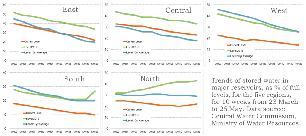
The Central Water Commission, Ministry of Water Resources, Government of India, monitors every day the quantity of water stored (and used from) each of the 91 major reservoirs of the country. It issues a bulletin every week that gives the weekly storage position of these reservoirs – the volume of water, the level of water in the reservoir and the change from the last week, the change from the same date last year and from the average on this date of the last ten years.

The water storage capacity of these 91 reservoirs taken together is 157.799 billion cubic metres (bcm) which is estimated to be about 62% of the total water storage capacity (in other smaller dams and storage structures all over the country) that has been built and is being used, and which is approximately 253.38 bcm. Out of these 91 reservoirs, hydro-electric power stations (with a capacity of 60 megawatts and more) are attached to 37 reservoirs.

In this illustration by Indiaclimate, for the first time the total storage capacity of the 91 major reservoirs has been visually mapped to show reservoir, state and zone capacities relative to each other and the total.

These are the reservoirs with state, reservoir name and full reservoir level in billion cubic metres (bcm). For a good quality file that you can print, write to us.

South zone reservoirs (AP for Andhra Pradesh, TG for Telengana, APTG for Andhra Pradesh and Telegana together, KAR for Karnataka, TN for Tamil Nadu, KER for Kerala): AP, Somasila (1.994); TG, Sriramsagar (2.3); TG, Lower Manair (0.621); APTG, Srisailam (8.288); APTG, Nagarjuna Sagar (6.841); KAR, Krishnaraja Sagra  (1.163); KAR, Tungabhadra (3.276); KAR, Ghataprabha (1.391); KAR, Bhadra (1.785); KAR, Linganamakki (4.294); KAR, Narayanpur (0.863); KAR, Malaprabha (Renuka) (0.972); KAR, Kabini (0.444); KAR, Hemavathy (0.927); KAR, Harangi (0.22); KAR, Supa (4.12); KAR, Vanivilas Sagar (0.802); KAR, Almatti (3.105); KAR, Gerusoppa (0.13); KER, Kallada (Parappar) (0.507); KER, Idamalayar (1.018); KER, Idukki (1.46); KER, Kakki (0.447); KER, Periyar (0.173); KER, Malapmuzha (0.224); TN, Lower Bhawani (0.792); TN, Mettur (Stanley) (2.647); TN, Vaigai (0.172); TN, Parambikulam (0.38); TN, Aliyar (0.095); TN, Sholayar (0.143). Total for 31 reservoirs 51.59 bcm

West zone reservoirs (GUJ for Gujarat, MAH for Maharashtra): GUJ, Ukai (6.615); GUJ, Sabarmati (Dharoi) (0.735); GUJ, Kadana (1.472); GUJ, Shetrunji (0.3); GUJ, Bhadar (0.188); GUJ, Damanaganga (0.502); GUJ, Dantiwada (0.399); GUJ, Panam (0.697); GUJ, Sardar Sarovar (1.566); GUJ, Karjan (0.523); MAH, Jayakwadi (Paithon) (2.171); MAH, Koyana (2.652); MAH, Bhima (Ujjani) (1.517); MAH, Isapur (0.965); MAH, Mula (0.609); MAH, Yeldari (0.809); MAH, Girna (0.524); MAH, Khadakvasla (0.056); MAH, Upper Vaitarna (0.331); MAH, Upper Tapi (0.255); MAH, Pench (Totaladoh) (1.091); MAH, Upper Wardha (0.564); MAH, Bhatsa (0.942); MAH, Dhom (0.331); MAH, Dudhganga (0.664); MAH, Manikdoh (Kukadi) (0.288); MAH, Bhandardara (0.304). Total for 27 reservoirs 27.07 bcm

East zone reservoirs (JHR for Jharkhand, ODI for Odisha, WB for West Bengal, TRI for Tripura): JHR, Tenughat (0.821); JHR, Maithon (0.471); JHR, Panchet Hill (0.184); JHR, Konar (0.176); JHR, Tilaiya (0.142); ODI, Hirakud (5.378); ODI, Balimela (2.676); ODI, Salanadi (0.558); ODI, Rengali (3.432); ODI, Machkund (Jalput) (0.893); ODI, Upper Kolab (0.935); ODI, Upper Indravati (1.456); WB, Mayurakshi (0.48); WB, Kangsabati (0.914); TRI, Gumti (0.312). Total for 15 reservoirs 18.83 bcm

Central zone reservoirs (UP for Uttar Pradesh, UTT for Uttarakhand, MP for Madhya Pradesh, CHT for Chhattisgarh): UP, Matatila (0.707); UP, Rihand (5.649); UTT, Ramganga (2.196); UTT, Tehri (2.615); MP, Gandhi Sagar (6.827); MP, Tawa (1.944); MP, Bargi (3.18); MP, Bansagar (5.166); MP, Indira Sagar (9.745); MP, Barna (0.456); CHT, Minimata Bangoi (3.046); CHT, Mahanadi (0.767). Total for 12 reservoirs 42.30 bcm

North zone reservoirs (HP for Himachal Pradesh, PUN for Punjab, RAJ for Rajasthan): HP, Gobind Sagar (Bhakra) (6.229); HP, Pong Dam (6.157); PUN, Thein  (2.344); RAJ, Mahi Bajaj Sagar (1.711); RAJ, Jhakam (0.132); RAJ, Rana Pratap Sagar (1.436). Total for 6 reservoirs 18.01 bcm

Filed Under: Current Tagged With: agriculture, Bharat, dam, drinking water, hydel, hydro, India, irrigation, reservoir, water, water pump, water resources, water storage

South India’s water emergency

April 11, 2017 by Climate portal editor Leave a Comment

ICP_res_20170410_topBy the end of the first week of April 2017, the most current and reliable indicator for stored water in south India showed how dire the situation has become. And the South-West monsoon is still about eight weeks away. The weekly data sheet on the stored water quantities in the 91 major reservoirs of India, which is maintained and released by the Central Water Commission, has in the 6 April 2017 release shown the scale of the water emergency.

Of the 31 reservoirs in the southern region (Kerala, Tamil Nadu, Karnataka, Telengana and Andhra Pradesh) that are among the major reservoirs of India, 18 have stored water that is less than 15% of their full capacities.

These 18 are (ranked by least water stored):
Nagarjuna Sagar, APTG, 0.00%
Sholayar, TN, 0.00%
Almatti, KAR, 0.03%
Kabini, KAR, 2.25%
Vanivilas Sagar, KAR, 2.74%
Tungabhadra, KAR, 3.21%
Vaigai, TN, 4.07%
Parambikulam, TN, 5.00%
Malaprabha (Renuka), KAR, 5.56%
Hemavathy, KAR, 5.72%
Mettur (Stanley), TN, 6.72%
Periyar, KER, 6.94%
Bhadra, KAR, 9.02%
Lower Bhawani, TN, 9.09%
Srisailam, APTG, 9.44%
Krishnaraja Sagar, KAR, 11.44%
Malapmuzha, KER, 11.61%
Aliyar, TN, 14.74%
(TN is Tamil Nadu, KER is Kerala, KAR is Karnataka, APTG is Andhra Pradesh and Telengana)

ICP_south_water_20170411

Using a municipal average of about 400 litres per day per household that is a typical designed supply (not delivered, for that’s another tale), how much water does this allow for the 60.51 million households of the southern region until the monsoon begins?

Tamil Nadu has 18.46 million households, Kerala has 7.83 million, Karnataka has 13.3 million, Andhra Pradesh and Telengana have 20.92 million. These together need 24.2 billion litres a day or, in reservoir storage terms, 0.024 billion cubic metres (bcm) a day. The 31 major reservoirs of southern India together have, as of 6 April 2017, 6.583 bcm. From this quantity is taken water for industrial, agricultural and commercial use.

These uses are given priority or water stocks are secured (never mind allocation and metering) especially by industry. Normally, what remains for household use is about a third of the available stock. This leaves, as on 6 April, about 2.19 bcm for household use, which will suffice the 60.51 million households of south India for about 90 days – but only provided, and this is the stringent, non-negotiable condition that must be enforced, all households especially urban keep within the 400 litres per household per day limit.

The situation does not improve even if the monsoon arrives on time and the first weeks deliver normal rainfall. It is only by July 5-15 that reservoir water stocks begin trending upwards. This is where the 90-day restricted supply can take south India to. But only if immediate and strict rationing is imposed, as it should have been, to allow for climatological variance, by 1 March 2017.

Filed Under: Latest Tagged With: Andhra Pradesh, Bharat, drought, India, Karnataka, Kerala, reservoir, Tamil Nadu, Telengana, water, water shortage, water supply

A race between monsoon and water

June 1, 2016 by Climate portal editor Leave a Comment

ICP_reservoirs_20160601

The southern states of Tamil Nadu, Karnataka, Andhra Pradesh and Telengana are in dire need of rainwater to replenish exceedingly low levels in reservoirs and all surface water structures. This water has come in the form of showers over the past five or six days, although the spread of the rainfall has been patchy, and whether rainwater has collected in significant quantities and percolated into sub-soil aquifers will not be known for at least another week.

Until 31 May 2016 the stored water situation as measured by the quantities recorded in the 91 major reservoirs of India was very grave indeed. The most recent weekly bulletin of the Central Water Commission, which monitors what is called the ‘live storage status’ of the 91 major reservoirs, was issued on 26 May. Out of the 91 reservoirs, 37 have hydro-electric power plants which deliver electricity to the states in which these reservoirs are and to the national grid.

The total ‘live storage’ capacity of these 91 reservoirs is 157.799 billion cubic metres (BCM) which is estimated as being about 62% of the total storage capacity of 253.388 BCM that is estimated to have been built or created. But the 26 May bulletin placed the total storage available in these reservoirs at 26.816 BCM, which is 17% of the total of 91 reservoirs. At this time in 2015, the total stored water was 49.119 BCM and the average of the last 10 years of storage at this time was 33.764 BCM. Thus, the stored water for the week ended 26 May is 55% of the quantity stored in 2015 and 79% of the quantity stored at this time averaged for the last ten years.

ICP_reservoir_trends_20160601

The Northern region is Himachal Pradesh, Punjab and Rajasthan. There are six reservoirs with total live storage capacity of 18.01 BCM. By 26 May the total storage in these reservoirs was 3.91 BCM which is 22% of the total live storage capacity. The stored volume at the corresponding period in 2015 was 43% and the stored volume of the average corresponding period of the last ten years was 29%.

The Eastern region is Jharkhand, Odisha, West Bengal and Tripura. There are 15 reservoirs with total live storage capacity of 18.83 BCM. By 26 May the total live storage in these reservoirs was 4.22 BCM which is 22% of total live storage capacity. The stored volume at the corresponding period in 2015 was 34% and the stored volume of the average corresponding period of the last ten years was 20%.

The Western region is Gujarat and Maharashtra. There are 27 reservoirs with total live storage capacity of 27.07 BCM. By 26 May the total live storage in these reservoirs was 3.90 BCM which is 14% of total live storage capacity. The stored volume at the corresponding period in 2015 was 26% and the stored volume of the average corresponding period of the last ten years was also 26%.

The Central region is Uttar Pradesh, Uttarakhand, Madhya Pradesh and Chhattisgarh. There are 12 reservoirs with total live storage capacity of 42.30 BCM. By 26 May the total live storage available in these reservoirs is 9.59 BCM which is 23% of total live storage capacity. The stored volume at the corresponding period in 2015 was 33% and the stored volume of the average corresponding period of the last ten years was 18%.

The Southern region is Andhra Pradesh, Telengana, combined projects in both states, Karnataka, Kerala and Tamil Nadu. There are 31 reservoirs with total live storage capacity of 51.59 BCM. By 26 May the total live storage available in these reservoirs was 5.21 BCM which is 10% of total live storage capacity. The stored volume at the corresponding period in 2015 was 27% and the stored volume of the average corresponding period of the last ten years was 20%.

Filed Under: Latest, Monsoon 2016 Tagged With: 2016, Bharat, dams, India, monsoon, reservoir, water

Why we need to save water right now

April 16, 2016 by Climate portal editor Leave a Comment

ICP_reservoirs_20160417

Every week, the Central Water Commission release the “live storage” data. By this the Commission means the quantity of water stored in what are called the 91 major reservoirs of India. From this group of what are also called the big dams – they are the biggest in the country – 37 have hydro-electric power plants attached that use the flow of water to generate electricity.

Together the 91 reservoirs can store, if they were full, 157.799 billion cubic metres (BCM). This amount is calculated as being about  62% of the entire “live storage” capacity of 253 BCM which is estimated to have been built as dams in India.

The CWC’s latest bulletin of 13 April 2016 delivers to us an immediate warning: the water stored in these major reservoirs together is under a quarter of their full storage level. The combined quantity stands at 35.839 BCM, which is 23% of the total live storage capacity of these reservoirs. This quantity is 67% of what was stored at this time last year, and is 77% of the average for ten years that is stored at this time of the year. This means we have less stored water compared with last year and compared with the ten year average for this time of year.

Here follows our sequence of alerts put out over the @indiaclimate Twitter feed:

Today, the 91 major reservoirs together hold 35.83 billion cubic metres (bcm) of #water. When all full they can hold 157.79 bcm

— Indiaclimate (@Indiaclimate) April 16, 2016

The total #water stored now is 23% of full storage by all the 91 reservoirs, and is 67% of the storage at this time last year. — Indiaclimate (@Indiaclimate) April 16, 2016

And moreover the total #water stored now is 77% of the average storage at this time for the last ten years. Now for the charts.

— Indiaclimate (@Indiaclimate) April 16, 2016

Water saving measures must immediately be followed by all households. Town and city municipal corporations and councils must immediately ask residents to reduce their use of water especially on activities like washing cars, watering lawns and swimming pools. District administrations need to immediately implement contingency plans for conserving water.

This chart shows the full reservoir level (blue) and current #water storage level (orange) for dams (by size) 69-91 pic.twitter.com/9LGQIddla6 — Indiaclimate (@Indiaclimate) April 16, 2016

Second chart: full reservoir level (blue) and current #water storage level (orange) for dams (by size) 46-68 pic.twitter.com/liMPJKoqfY

— Indiaclimate (@Indiaclimate) April 16, 2016

Third chart: full reservoir level (blue) and current #water storage level (orange) for dams (by size) 23-45 pic.twitter.com/CKjHboXIF4 — Indiaclimate (@Indiaclimate) April 16, 2016

Fourth chart: full reservoir level (blue) and current #water storage level (orange) for dams (by size) 1-22 pic.twitter.com/1UcvS5QJrE

— Indiaclimate (@Indiaclimate) April 16, 2016

Filed Under: Blogs, Current Tagged With: Bharat, big dam, Central Water Commission, India, reservoir, water, water resources, water shortage

From space, a district and its water

October 9, 2015 by Climate portal editor 3 Comments

RG_ICP_water_district_map_201510

In this panel of maps the relationship between the district of Parbhani (in the Marathwada region of Maharashtra) and water is graphically depicted over time. The blue squares are water bodies, as seen by a satellite equipped to do so. The intensity of the blue colour denotes how much water is standing in that coloured square by volume – the deeper the blue, the more the water.

Water bodies consist of all surface water bodies and these are: reservoirs, irrigation tanks, lakes, ponds, and rivers or streams. There will be variation in the spatial dimensions of these water bodies depending on how much rainfall the district has recorded, and how the collected water has been used during the season and year. In addition to these surface water bodies, there are other areas representing water surface that may appear, such as due to flood inundations, depressions in flood plains, standing water in rice crop areas during transplantation stages. Other than medium and large reservoirs, these water features are treated as seasonal and some may exist for only a few weeks.

RG_ICP_water_district_map_201510_section

Click for a section of the full size image. The detail can be mapped to panchayat level.

The importance of monitoring water collection and use at this scale can be illustrated through a very brief outline of Parbhani. The district has 830 inhabited villages distributed through nine tehsils that together occupy 6,214 square kilometres, eight towns, 359,784 households in which a population of 1.83 million live (1.26 rural and 0.56 million urban). This population includes 317,000 agricultural labourers and 295,000 cultivators – thus water use and rainfall is of very great importance for this district, and indeed for the many like it all over India.

This water bodies map for Parbhani district is composed of 18 panels that are identical spatially – that is, centred on the district – and display the chronological progression of water accumulation or withdrawal. Each panel is a 15-day period, and the series of mapped fortnights begins on 1 January 2015.

The panels tell us that there are periods before the typical monsoon season (1 June to 30 September) when the accumulation of water in surface water bodies has been more than those 15-day periods found during the monsoon season. See in particular the first and second fortnights of March, and the first fortnight of April.

During the monsoon months, it is only the two fortnights of June in which the accumulation of water in the surface water bodies of Parbhani district can be seen. The first half of July and the second half of August in particular have been recorded as relatively dry.

This small demonstration of the value of such information, provided at no cost and placed in the public domain, is based on the programme ‘Satellite derived Information on Water Bodies Area (WBA) and Water Bodies Fraction (WBF)’ which is provided by the National Remote Sensing Centre (NRSC), Indian Space Research Organisation (ISRO), Department of Space, Government of India.

For any of our districts, such continuous monitoring is an invaluable aid to: facilitate the study of water surface dynamics in river basins and watersheds; analyse the relationships between regional rainfall scenarios and the collection and utilisation of water in major, medium reservoirs and irrigation tanks and ponds; inventory, map and administer the use of surface water area at frequent intervals, especially during the crop calendar applicable to district and agro-ecological zones.

Filed Under: Blogs, Monsoon 2015 Tagged With: agriculture, district, ISRO, Maharashtra, monsoon, NRSC, rain, remote sensing, reservoir, river, rural, space, town, urban, village, water

Decoding reservoirs for the rest of us

July 21, 2014 by Climate portal editor Leave a Comment

RG_ICP_reservoirs_201407_imageEvery week, the Central Water Commission releases to the public and to government departments the numbers that describe how much water is stored in 85 reservoirs in India. These are the reservoirs designated as nationally important, because of their roles in providing water for large irrigated command areas and for generating hydro-electric power (37 of these dams).

These readings are taken as the authoritative compilation of the current weekly state of water storage, and are widely used in government. Amongst the uses is to recommend the rationing of water consumption in the states and urban settlements. Another use is to help determine what advice to broadcast to our farmers about when they can sow seeds (if their fields are irrigated by the canals that radiate outwards from these dams).

RG_ICP_reservoirs_panel_201407But of course these are only 85, even if they are the biggest. Whether Bargi in Madhya Pradesh is half full does not interest in the least a farmer in Purnea, Bihar. Whether Tungabhadra in Karnataka is filling up well in the last two weeks is of no consequence to the residents of Rohtak in Haryana. That Yeldari in Maharashtra has water at a level very much lower it should be at this time of the year does not affect the cultivators of Virudhanagar, Tamil Nadu.

Bihar has 24 large dams (and groundwater) and Tamil Nadu has 116 while Madhya Pradesh has 898 large dams other than Bargi, but we have no weekly or monthly information about how much water these hold, in the first week of June or at end July. And this is what we don’t know for all the 4,839 dams – in the national register of large dams – that are not amongst the list of 85. The Central Water Commission tells us that it uses the combined readings for the 85 large dams because, with their total of about 155 billion cubic metres (bcm) of water storage (if they are all full), they form a large portion of the approximately 254 (bcm) of total reservoir storage available in India (excluding tanks, ponds and traditional water storage structures). But, for the smallholder cultivator and the town council of a Class 2 urban settlement, it is the 50 million cubic metres reservoir in the next taluka that they depend on for water, not on any of the big 85.

What can we then do with the weekly reservoir storage bulletin from the CWC? My approach is to treat it as an indicator of the collection of rainfall by reservoirs in the same meteorological region and agro-ecological zone. When the list is divided into ten groups, by reservoir size, we see far more clearly the effect of the last two weeks of rainfall on the storage levels. Until we can persuade state and central governments to invest in widespread and cheap monitoring of as many of our water storage receptacles as possible, we may use the CWC bulletin as an indicator.

By Rahul Goswami

The panel of charts shows water storage ranges (at full capacity of the dams) for the groups of reservoirs. Starting with the smallest first: 56 million cubic metres (mcm) to 176 mcm (tenth group); 184 mcm to 380 mcm (ninth group); 399 mcm to 523 mcm (eighth group); 524 mcm to 735 mcm (seventh group); 767 mcm to 927 mcm (sixth group); 935 mcm to 1.436 billion cubic metres (bcm) (fifth group); 1.456 bcm to 1.994 bcm (fourth group); 2.171 bcm to 2.676 bcm (third group); 3.046 bcm to 5.378 bcm (second group); 5.649 bcm to 9.745 bcm (first group).

Filed Under: Blogs, Monsoon 2014 Tagged With: 2014, Central Water Commission, command area, dam, hydel, hydro-electric, irrigation, monsoon, reservoir, storage, water scarcity

Government readies drought plan

July 18, 2014 by Climate portal editor Leave a Comment

The drought management information system is in place and working.

The drought management information system is in place and working.

The Ministry of Agriculture through the Department of Agriculture and Cooperation has released its national drought crisis management plan. This is not taken as the indicator that drought conditions are expected to set in, but to prepare for them where they are identified. In the fifth week of the South-West monsoon, the trend continues to be that week by week, the number of districts that have recorded less rainfall than they normally receive outnumber those districts with normal rainfall. When this happens over a prolonged period, such as four to six weeks, drought-like conditions set in and the administration prepares for these conditions. [Links to the documents are at the end of this posting.]

There are a group of ‘early warning indicators’ for the kharif crop (sowing June to August) which are looked for at this time of the year. They are: (1) delay in the onset of South-West monsoon, (2) long ‘break’ activity of the monsoon, (3) insufficient rains during June and July, (4) rise in the price of fodder, (5) absence of rising trend in the water levels of the major reservoirs, (6) drying up of sources of rural drinking water, (7) declining trend in the progress of sowing over successive weeks compared to corresponding figures for ‘normal years’.

On this list, points 1 and 2 are true, 3 is true for June and July until now, 4 and 5 are true, we have insufficient information for 6 and 7 but from mid-May there have been a number of media reports on water scarcity in the districts of peninsular, central and northern India. Thus the state of the ‘early warning’ indicators taken together have triggered the issuing of the government’s drought crisis management plan.

“The identified priorities of CMP are to clarify the goals and define the roles and responsibilities of various responders (ministries / departments, organisations and individuals) involved in crisis management, and putting together a communication process for quickly notifying the public in the event of a crisis,” the ministry has explained. “The plan outlined in this document does not replace the emergency procedures or contingency action plans already drawn by different agencies, but has been developed to address crisis situations that have the potential for a much greater impact on the nation.”

The reason we have plans at the national and state level, and contingency plans for each district in the event of drought, drought-like conditions, and water scarcity is the combination of several factors:

  • Every year more than 50 million people are directly exposed to drought and its effects, with 16% of India’s total area considered prone to drought.
  • In four out of every ten years rainfall in India is erratic.
  • Drought in varying degrees affects 68% of the sown area.
  • Regions with annual rainfall of 750-1,125 millimetres account for 35% of the land area and are drought prone.
  • Most of these zones lie in the arid (19.6%), semi-arid (37%) and sub-humid (21%) regions of India.
  • Up to three-quarters of the annual average rainfall occurs over 120 days of the year. A third of the total land area receives less than 750 mm of rainfall and is chronically drought prone.

In this ‘warning phase’ – which many districts have entered – the crisis management plan calls for short-term water conservation measures by municipal and district agencies, water-budgeting by the Ministry of Water Resources (Irrigation), the Ministry of Urban Development and by the Department of Drinking Water and Sanitation. Municipal and town councils are instructed to identify alternative sources of water when the town is in a ‘warning’ period and the supply of water may be restricted to 70 litres per person per day (about half of the normal 135). Water rationing and restricted use become urgent with municipal and town councils instructed to ensure that drinking water is not used for other purposes (like washing cars, watering gardens, and so on).

State governments have in place standing instructions of designating officers responsible for meeting the needs of rural and urban citizens during drought and drought-like conditions. This document contains the list of nodal officers of the line ministries and departments, and of the Ministry of Agriculture’s drought management division, with their contact details. The full crisis management plan of the Ministry of Agriculture, Department of Agriculture and Cooperation, is here.

Filed Under: Latest, Monsoon 2014 Tagged With: 2014, contingency, district, drought, India, kharif, ministry, monsoon, municipality, reservoir, sarcity, town, urban development, water resources

Indiaclimate twitter

Tweets by @Indiaclimate

Notable

Between contemplation and climate

Whether or not the USA, Europe, the Western world, the industrialised Eastern world (China, Japan, South Korea, Taiwan), adhere to or not their paltry promises about being more responsible concerning the factors that lead to climate change, is of very little concern to us. We have never set any store by international agreements on climate […]

The ‘Hindu’, ignorant about weather and climate, but runs down IMD

We find objectionable the report by ‘The Hindu’ daily newspaper accusing the India Meteorological Department of scientific shortcoming (‘IMD gets its August forecast wrong’, 1 September 2016). The report claims that the IMD in June 2016 had forecast that rains for August would be more than usual but that the recorded rain was less than […]

dialogue

  • Misreading monsoon | Resources Research on Misreading monsoon
  • Satish on A tribute to the weathermen of Bharat
  • Climate portal editor on A tribute to the weathermen of Bharat
  • Climate portal editor on A tribute to the weathermen of Bharat
  • Climate portal editor on A tribute to the weathermen of Bharat

Categories

Copyright © 2025 indiaclimateportal.org.