The India Climate Observatory

Commentary, action and research on climate and development in India

  • Home
  • About
  • Monsoon 2018
  • Current
  • Bulletin
  • Contact
  • Announcements

Dry tale of ten rain weeks

August 23, 2014 by Climate portal editor Leave a Comment


RG_ICP_20140823_pic

What a monsoon season is can no longer be judged by the over-simplified sums that assure the country about departures from an ‘average’ and the potential of ‘catching up’ as a season progresses. Since the 2009 drought, the awareness of farmers’ cooperatives and groups about the meteorological products and data available with the only provider of such measurements has grown. What has not grown is the willingness of government agencies on the one hand, and the consuming public on the other, to make similar investments in pursuing such clarity.

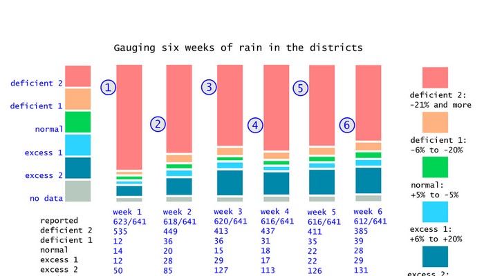
The area chart with its jagged stripes is the simplest indicator of the gap between the central government’s sanguine response to a very serious monsoon deficit, and the conditions that our districts have recorded since the first week of June 2014. The chart, based on the Indian Meteorological Department’s weekly district recordings of rainfall, plots 641 of these readings over ten weeks.

Our modified monsoon measure shows the overall trend, and made the case early for state and district level relief.

Our modified monsoon measure shows the overall trend, and made the case early for state and district level relief.

It is immediately clear that the green stripe (for ‘normal’) has at no point been significantly larger than any one of the other three important stripes, coloured deep red (for ‘scanty’), peach (for ‘deficient’) and blue (for ‘excess’).

In the seventh week of monsoon 2014 (17 to 23 July 2014) the number of districts that recorded normal rainfall for that week was 126, and that is the maximum number that have reported normal rainfall for a week. The next highest number of districts reporting normal for a week is 92, which was for the preceding week (10 to 16 July 2014).

More serious is the district-level reporting for the following three weeks – ending 30 July, 06 August and 13 August – which show the number of districts that reported normal rain for each week was less than 20% of the number of districts that reported deficient, scanty or excess rainfall. It was during this period that central government ministries and agencies did not publicly disclose the widespread monsoon deficiency and which did not act, by alerting the consuming public, to the short and medium term consequences of the monsoon crisis.

The modified monsoon measure (which has been advocated as a method to prime local administrations towards early recognition of the need for relief and remedial action in drought and drought-like conditions) displays to greater effect the glaring imbalance between ‘normals’ and their absence in the districts. In every one of the ten weeks, the light red bar (the ‘deficient 2’ measure, for rainfall of 21% less and lower) dominates.

Otherwise it is the dark blue bar (the ‘excess 2’ measure, for rainfall of 21% more and above) which is next most prominent. This is the clearest signal from a close reading of the district rainfall reportage that volatility in rainfall quantities is the feature most visible throughout monsoon 2014.

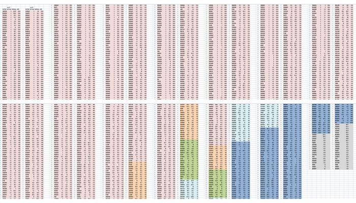
The IMD’s running table of the distict rainfall departures confirms this trend for monsoon 2014. In many of the 36 meteorological sub-divisions, weeks of scanty and deficient rainfall are broken by normal or excess rainfall, only to return to scanty and deficient. Taking the districts of Odisha and of western Madhya Pradesh as examples, this volatility can be seen at a glance, and is in concurrence with the overall trends that the modified monsoon measure has been indicating for the last two months.

IMD_weekly_ODI_MP_sm

Filed Under: Current, Monsoon 2014 Tagged With: 2014, agriculture, district, drought, IMD, India, inflation, kharif, monsoon, rabi, rainfall

The IMD’s shaky monsoon math

August 7, 2014 by Climate portal editor Leave a Comment

RG_ICP_pic_20140806

Over eight weeks of recorded monsoon rain, the district-level data available with the India Meteorological Department (IMD) portrays a picture that is very different from its ‘national’ and ‘regional’ advice about the strength and consistency of rainfall.

In its first weekly briefing on the monsoon of August 2014, IMD said: “For the country as a whole, cumulative rainfall during this year’s monsoon (01 June to 30 July 2014) has so far upto 30 July been 23% below the Long Period Average.” Out of 36 meteorological sub-divisions, said the IMD, the rainfall has been normal over 15 and deficient over 21 sub-divisions.

Readings for each district that has reported rainfall consistently for eight weeks. The columns represent the percentage value of actual rainfall for each district against their normal rainfall for eight weeks.

Readings for each district that has reported rainfall consistently for eight weeks. The columns represent the percentage value of actual rainfall for each district against their normal rainfall for eight weeks.

However, we have compiled a far more realistic reading of the monsoon season so far, from the IMD’s own data. For the 614 individual readings from districts that have regular rainfall readings, we have the following: 86 districts have registered scanty rainfall (-99% to -60%); 281 districts have registered deficient rainfall (-59% to -20%); 200 districts have registered normal rainfall (-19% to +19%); and 47 districts have registered excess rainfall (+20% and more).

Moreover, using our running weekly district-level monsoon meter – the details of which and the reasoning for which you will find in here – we see that there was a substantial dip in the number of districts registering ‘deficient 2’ rainfall, which is less than 21% of the normal and lower, during the seventh week of rain, that is the week of 17 to 23 July. But the general trend returned the following week, 24 to 30 July.

What this means, and the bar chart we have provided to illustrate the 614 individual values leaves us in no doubt, is that 367 out of 614 districts have had meagre rain for eight weeks. This also means that over eight weeks where there should have been rainfall that – as the IMD predicted in early June – would be around 95% of the ‘long period average’, instead three out of five districts have had less than 80% of their usual quota.

Our running weekly district-level monsoon meter to aid governance decisions shows the overall trend has not changed substantially in the last fortnight despite good rains during the seventh monsoon week.

Our running weekly district-level monsoon meter to aid governance decisions shows the overall trend has not changed substantially in the last fortnight despite good rains during the seventh monsoon week.

Unfortunately, the press and media – in particular the business and financial media – persist in reporting ‘national’ deficits and whether monsoon 2014 will ‘make up’ the average in the remaining period. This approach must be corrected by the IMD’s departmental divisions as it incorrectly makes popular the notion that total rainfall over a designated number of weeks is the most important monsoon metric (See ‘Why there is no ‘normal’ in our monsoon’). Of course it is not so, as different crops follow their own crop calendars according to the agro-ecological regions they are grown in, and require optimum rain at certain times during their respective crop calendars.

The following examples show why such reporting can be misleading:

From Reuters: “August rains hold the key to India’s major summer crops such as rice, soybean, cane and cotton, after a wet end to July failed to make up fully for a dry start to the four-month monsoon season. A late revival shrank the shortfall in rain to around 10 percent below average in July, the India Meteorological Department’s update showed on Thursday, a sharp improvement from the 43 percent deficit in the first month of the season.”

From Bloomberg: “Monsoon crops are sown from June and harvested from October. The country had less than 40 percent of average rains in the first six weeks of the monsoon season that runs through September. The shortage shrank to 23 percent by end-July. Oilseed planting in India is poised to slump as much as 24 percent to the lowest since 2002 after a weak start to the monsoon.”

From The Hindu: “With the country receiving good rain in July, monsoon deficiency has gone down to 23 percent, the MET department on Friday said. While the monsoon deficiency at the national level in June was 43 per cent, by July end it has come down to 23 per cent. Central India, which saw little rain in June, has by now seen some good rain. It received 402.2 mm of rainfall as compared to expected rainfall of 477.7 mm with a deficiency of 16 per cent, much lesser compared to other parts of the country.”

From Business Standard: “According to the India Meteorological Department (IMD), the rains managed to recoup much of the June losses due to strong revival over the central and western regions, and parts of northern India. Weather officials said the momentum of July would continue till about August 10 and then slacken a bit.”

From Mint: “India’s July rain deficit narrowed to 10% of the long-term average for the month, marking a recovery from the driest June in five years, the India Meteorological Department (IMD) said, as kharif crop sowing picked up in tandem. The shrinking of the rainfall deficit in July comes at a time when policymakers have been concerned about the impact of a below-average monsoon on foodgrain production and inflation. The June-September monsoon accounts for more than 70% of the annual rainfall in India and irrigates crops grown on half the country’s farmlands.”

Filed Under: Blogs, Current, Monsoon 2014 Tagged With: 2014, agriculture, climate, crop, district, food, foodgrain, IMD, India, inflation, irrigation, kharif, meteorology, monsoon, rainfall, water

Deadly negligence

August 4, 2014 by Climate portal editor Leave a Comment

A resident looks at the debris of her damaged house after a landslide at Malin village, Pune district, in Maharashtra on 30 July 2014. Photo: Reuters/Stringer

A resident looks at the debris of her damaged house after a landslide at Malin village, Pune district, in Maharashtra on 30 July 2014. Photo: Reuters/Stringer

Two months of monsoon that have delivered rainfall considerably below normal have given way to an end July and early August that has brought torrents of rain in some locations, and with it destruction and the loss of life.

In the last week, there has been a landslide in the Pune district, western Maharashtra, in which the death toll has risen to over 100. There has been a landslide in Nepal, along the Bhote Kosi river, around 120 kilometres from Kathmandu, which is reported to have killed over 100 and displaced thousands. The situation there has led to an emergency in north Bihar, through which the Kosi flows, with some 65,000 people being evacuated from nine districts.

In the Bay of Bengal, 40 trawlers are reported to have gone missing in bad weather; there are estimated to be some 650 fishermen on board the vessels. In the Munshiganj district of central Bangladesh, about 40 kilometres from Dhaka, a ferry on the Padma river sank with about 200 on board.

Every one of these events is repeated every monsoon – landslide, flood, river ferry sinking, fishing trawlers missing at sea – with little indication that learning takes place about how to contain the impacts and how to prepare for them when they become threats.

The threat from the Kosi developed after a massive landslide blocked the main course of Bhote Kosi river, a tributary of the Kosi, in Sindhupalchok district of Nepal. The landslide brought down rock which has dammed the river, immediately forming a large lake. Authorities in Nepal have been trying to release the water without endangering downstream regions.

The central government has said (o4 August Monday) that there is no immediate threat of a flood. India’s Home Ministry, the Nepal Water Commission, India’s Central Water Commission and India’s National Crisis Management Committee are coordinating preparations, relief and technical expertise. The Bihar state government is carrying our the evactuations to avoid a situation like 2008, when a breach in the Kosi embankment at Kushaha in Nepal caused one of the most devastating floods.

The landslide in Nepal and the emergency in downstream Bihar has again revived the debate as to whether a dam would help solve the problem of floods in north Bihar. Since 1945 there have been commissions to study the problem and make their recommendations, and proposed dams have been abandoned for compelling reasons – that the river valleys have unstable foundations, that the region is a high-risk seismic zone, that the reservoirs would silt up far sooner than expected, and that the costs would be prohibitive.

The tragic incidents in Maharashtra, in the Bay of Bengal, and in Munshiganj (Bangladesh) have much more to do with the wilful neglect of conditions that have built up a cumulative threat. The landslide in Pune district which has buried portions of a village, its residents and cattle, was according to a number of media reports the result of factors that included what appears to be no recognition of the most obvious risks. The hill above the village of Malin is reported to have been the site of wind turbines (which need heavy machinery to erect them) and also farming that used heavy equipment to level the top of the hill. Whichever factor is true, the use to which hill land was put was a threat to the settlement at its base, and little thought was given to monsoon conditions.

That such a large group of trawlers went missing in the Bay of Bengal near Kakdwip in South 24 Parganas district of West Bengal has to do with economic reasons, which media reports will at this stage not uncover. Three of the trawlers are reported as having capsized and authorities in West Bengal are said to have ‘traced’ 25 of the vessels. The question is: when squally weather and forecasts of heavy rain trigger warning to fishermen, why do they ignore these warnings and risk their lives? The usual answer is loan economics, for the trawler owners can’t afford delays in servicing the loans with which they bought the vessels, and are under pressure to find and sell fish, which is when safety considerations are ignored.

Similar considerations lead in Bangladesh to riverine ferries – a common mode of transport in great deltas – being overloaded to far beyond their capacities. The monsoon brings with it weather conditions that demand safety first, but when economic desperation and plain greed set in, elementary precautions that are meant to save lives are discarded.

Filed Under: Latest, Monsoon 2014 Tagged With: Bangladesh, Bay of Bengal, Bihar, cyclone, disaster, evacuation, ferry, fishermen, flood, India, Kosi, land use, landslide, Maharashtra, monsoon, Nepal, rehabilitation, rescue, water

Seeing the local in six rain weeks

July 23, 2014 by Climate portal editor Leave a Comment

RG_ICP_20140723_picWe urge the Ministry of Earth Sciences, the India Meteorology Department and the Ministry of Information and Broadcasting to cease the use of a ‘national’ rainfall average to describe the progress of monsoon 2014. This is a measure that has no meaning for cultivators in any of our agro-ecological zones, and has no meaning for any individual taluka or tehsil in the 36 meteorological sub-divisions. What we need to see urgently adopted is a realistic overview that numerically and graphically explains the situation, at as granular a level as possible.

Using a revised categorisation of rainfall sufficiency levels (the method and the reasoning is available here) we find that for the fifth and sixth weeks of monsoon, there has been a small improvement which does not lower the high likelihood of drought conditions becoming prevalent in districts and scarcity of water for our settlements. The full-size chart is available here as an image, and explains in detail the rainfall that districts are reporting.

The fifth monsoon week is 03 to 09 July 2014 and the sixth monsoon week is 10 to 16 July 2014. There has been a small addition to the revised normal rainfall category (-5% to +5%), rising from 18 districts recording normal rainfall in the 4th week to 22 in the 5th and 28 in the 6th. There has also been an improvement in the number of districts recording deficit-2 levels of rainfall (-21% and more) with 437 in the 4th week, 411 in the 5th week and 385 in the 6th week. For the remainder of July the likelihood of more rainfall in the districts that have recorded normal or excess-1 (+6% to +20%) is small, according to the available forecasts, and this means that monsoon 2014 will begin August with far fewer districts registering normal rainfall than they should at this stage.

Filed Under: Current, Monsoon 2014 Tagged With: 2014, agriculture, crop, deficient, district, drought, monsoon, normal, rainfall, scanty, scarce, sowing, water

Decoding reservoirs for the rest of us

July 21, 2014 by Climate portal editor Leave a Comment

RG_ICP_reservoirs_201407_imageEvery week, the Central Water Commission releases to the public and to government departments the numbers that describe how much water is stored in 85 reservoirs in India. These are the reservoirs designated as nationally important, because of their roles in providing water for large irrigated command areas and for generating hydro-electric power (37 of these dams).

These readings are taken as the authoritative compilation of the current weekly state of water storage, and are widely used in government. Amongst the uses is to recommend the rationing of water consumption in the states and urban settlements. Another use is to help determine what advice to broadcast to our farmers about when they can sow seeds (if their fields are irrigated by the canals that radiate outwards from these dams).

RG_ICP_reservoirs_panel_201407But of course these are only 85, even if they are the biggest. Whether Bargi in Madhya Pradesh is half full does not interest in the least a farmer in Purnea, Bihar. Whether Tungabhadra in Karnataka is filling up well in the last two weeks is of no consequence to the residents of Rohtak in Haryana. That Yeldari in Maharashtra has water at a level very much lower it should be at this time of the year does not affect the cultivators of Virudhanagar, Tamil Nadu.

Bihar has 24 large dams (and groundwater) and Tamil Nadu has 116 while Madhya Pradesh has 898 large dams other than Bargi, but we have no weekly or monthly information about how much water these hold, in the first week of June or at end July. And this is what we don’t know for all the 4,839 dams – in the national register of large dams – that are not amongst the list of 85. The Central Water Commission tells us that it uses the combined readings for the 85 large dams because, with their total of about 155 billion cubic metres (bcm) of water storage (if they are all full), they form a large portion of the approximately 254 (bcm) of total reservoir storage available in India (excluding tanks, ponds and traditional water storage structures). But, for the smallholder cultivator and the town council of a Class 2 urban settlement, it is the 50 million cubic metres reservoir in the next taluka that they depend on for water, not on any of the big 85.

What can we then do with the weekly reservoir storage bulletin from the CWC? My approach is to treat it as an indicator of the collection of rainfall by reservoirs in the same meteorological region and agro-ecological zone. When the list is divided into ten groups, by reservoir size, we see far more clearly the effect of the last two weeks of rainfall on the storage levels. Until we can persuade state and central governments to invest in widespread and cheap monitoring of as many of our water storage receptacles as possible, we may use the CWC bulletin as an indicator.

By Rahul Goswami

The panel of charts shows water storage ranges (at full capacity of the dams) for the groups of reservoirs. Starting with the smallest first: 56 million cubic metres (mcm) to 176 mcm (tenth group); 184 mcm to 380 mcm (ninth group); 399 mcm to 523 mcm (eighth group); 524 mcm to 735 mcm (seventh group); 767 mcm to 927 mcm (sixth group); 935 mcm to 1.436 billion cubic metres (bcm) (fifth group); 1.456 bcm to 1.994 bcm (fourth group); 2.171 bcm to 2.676 bcm (third group); 3.046 bcm to 5.378 bcm (second group); 5.649 bcm to 9.745 bcm (first group).

Filed Under: Blogs, Monsoon 2014 Tagged With: 2014, Central Water Commission, command area, dam, hydel, hydro-electric, irrigation, monsoon, reservoir, storage, water scarcity

Government readies drought plan

July 18, 2014 by Climate portal editor Leave a Comment

The drought management information system is in place and working.

The drought management information system is in place and working.

The Ministry of Agriculture through the Department of Agriculture and Cooperation has released its national drought crisis management plan. This is not taken as the indicator that drought conditions are expected to set in, but to prepare for them where they are identified. In the fifth week of the South-West monsoon, the trend continues to be that week by week, the number of districts that have recorded less rainfall than they normally receive outnumber those districts with normal rainfall. When this happens over a prolonged period, such as four to six weeks, drought-like conditions set in and the administration prepares for these conditions. [Links to the documents are at the end of this posting.]

There are a group of ‘early warning indicators’ for the kharif crop (sowing June to August) which are looked for at this time of the year. They are: (1) delay in the onset of South-West monsoon, (2) long ‘break’ activity of the monsoon, (3) insufficient rains during June and July, (4) rise in the price of fodder, (5) absence of rising trend in the water levels of the major reservoirs, (6) drying up of sources of rural drinking water, (7) declining trend in the progress of sowing over successive weeks compared to corresponding figures for ‘normal years’.

On this list, points 1 and 2 are true, 3 is true for June and July until now, 4 and 5 are true, we have insufficient information for 6 and 7 but from mid-May there have been a number of media reports on water scarcity in the districts of peninsular, central and northern India. Thus the state of the ‘early warning’ indicators taken together have triggered the issuing of the government’s drought crisis management plan.

“The identified priorities of CMP are to clarify the goals and define the roles and responsibilities of various responders (ministries / departments, organisations and individuals) involved in crisis management, and putting together a communication process for quickly notifying the public in the event of a crisis,” the ministry has explained. “The plan outlined in this document does not replace the emergency procedures or contingency action plans already drawn by different agencies, but has been developed to address crisis situations that have the potential for a much greater impact on the nation.”

The reason we have plans at the national and state level, and contingency plans for each district in the event of drought, drought-like conditions, and water scarcity is the combination of several factors:

  • Every year more than 50 million people are directly exposed to drought and its effects, with 16% of India’s total area considered prone to drought.
  • In four out of every ten years rainfall in India is erratic.
  • Drought in varying degrees affects 68% of the sown area.
  • Regions with annual rainfall of 750-1,125 millimetres account for 35% of the land area and are drought prone.
  • Most of these zones lie in the arid (19.6%), semi-arid (37%) and sub-humid (21%) regions of India.
  • Up to three-quarters of the annual average rainfall occurs over 120 days of the year. A third of the total land area receives less than 750 mm of rainfall and is chronically drought prone.

In this ‘warning phase’ – which many districts have entered – the crisis management plan calls for short-term water conservation measures by municipal and district agencies, water-budgeting by the Ministry of Water Resources (Irrigation), the Ministry of Urban Development and by the Department of Drinking Water and Sanitation. Municipal and town councils are instructed to identify alternative sources of water when the town is in a ‘warning’ period and the supply of water may be restricted to 70 litres per person per day (about half of the normal 135). Water rationing and restricted use become urgent with municipal and town councils instructed to ensure that drinking water is not used for other purposes (like washing cars, watering gardens, and so on).

State governments have in place standing instructions of designating officers responsible for meeting the needs of rural and urban citizens during drought and drought-like conditions. This document contains the list of nodal officers of the line ministries and departments, and of the Ministry of Agriculture’s drought management division, with their contact details. The full crisis management plan of the Ministry of Agriculture, Department of Agriculture and Cooperation, is here.

Filed Under: Latest, Monsoon 2014 Tagged With: 2014, contingency, district, drought, India, kharif, ministry, monsoon, municipality, reservoir, sarcity, town, urban development, water resources

Gauging four weeks of rain in the districts

July 8, 2014 by Climate portal editor Leave a Comment

ICP_four_weeks_rain_graphic_20140709

We now have rain data for four complete weeks from the India Meteorological Department (IMD) and for all the districts that have reported the progress of the monsoon. The overall picture is even more serious than reported earlier because of the falling levels of water in the country’s major reservoirs. [05 to 11 June is the first week. 12 to 18 June is the second week. 19 to 25 June is the third week. 26 June to 02 July is the fourth week.]

Using the new measure of assessing the adequacy of district rainfall (and not the meteorological gradations that is the IMD standard), in the fourth week of the monsoon the number of districts that reported normal rains in that week (+5% to -5%) is 16; deficient 1 (-6% to -20%) is 31; deficient 2 (-21% and more) is 437; excess 1 (+6% to +20%) is 17; excess 2 (+21% and more) is 113; no data was reported from 25.

Filed Under: Monsoon 2014, Reports & Comment Tagged With: 2014, contingency, district, drought, earth science, forecast, hydrology, IMD, India, monsoon, rainfall

Why there is no ‘normal’ in our monsoon

July 4, 2014 by Climate portal editor Leave a Comment

RG_ICP_monsoon_20140704

The idea of a ‘revival’ of a delayed and weakened monsoon is a misleading one and the country’s earth science agencies must advise against the term being used. In particular, our news media must cease using this term as it implies, incorrectly, that rainfall can be ‘made up’ even though current ‘averages’ are low.

This group of maps of the 2014 monsoon is in three parts. Each part is composed of four separate but linked maps, two each in two rows. This is how you read each of the three sets: the top left map in a group of four shows the anomaly (in millimetres) of rainfall for the days measured. In this map, ochre yellow and dark growns are regions with the least rain compared to what they should have received, while those shaded in blues have received more than they normally do. The second map, top right, shows the percent of normal rain - light and dark browns being percentages very much lower than normal and greens and blues above. The lower left map in each group shows the accumulated rainfall for the measured days in millimetres, with green then blue and then orange showing the increasing levels of accumulated rain. In contrast, the lower right map shows the normal cumulative rainfalls for the same period. As with the group of four maps for the seven day period, the groups for the ten and 30 day rainfall measurement cycles follow the same pattern. In this panel, the seven day period is 26 June to 02 July 2014, the ten day period is 23 June to 02 July 2014 and the 30 day period is 03 June to 02 July 2014. The maps are by the Climate Prediction Center, NOAA Center for Weather and Climate Prediction, USA.

This group of maps of the 2014 monsoon is in three parts. Each part is composed of four separate but linked maps, two each in two rows.
This is how you read each of the three sets: the top left map in a group of four shows the anomaly (in millimetres) of rainfall for the days measured. In this map, ochre yellow and dark browns are regions with the least rain compared to what they should have received, while those shaded in blues have received more than they normally do. The second map, top right, shows the percent of normal rain – light and dark browns being percentages very much lower than normal and greens and blues above.
The lower left map in each group shows the accumulated rainfall for the measured days in millimetres, with green then blue and then orange showing the increasing levels of accumulated rain. In contrast, the lower right map shows the normal cumulative rainfalls for the same period.
As with the group of four maps for the seven day period, the groups for the ten and 30 day rainfall measurement cycles follow the same pattern. In this panel, the seven day period is 26 June to 02 July 2014, the ten day period is 23 June to 02 July 2014 and the 30 day period is 03 June to 02 July 2014.
The maps are by the Climate Prediction Center, NOAA Center for Weather and Climate Prediction, USA.

This is simply not so. A normal monsoon is certainly not one that can statistically be called ‘normal’ on the basis of cumulative rainfall for a region – such as any one of our 36 meteorological sub-divisions – adding up to what is expected over four weeks after a few heavy showers in the last few days have helped tilt the reading from ‘below normal’ to ‘normal’. The three panels of maps alongside convincingly explain why.

Yet senior meteorological department officials, including those at the National Weather Forecasting Centre at the India Meteorological Department, issue statements such as “the monsoon has revived in many parts of central and north India”. This may be meant to assuage the concerns especially of farming and cultivating households, but in fact they only distract from the recognition a continuing climatological crisis urgently needs.

The evidence till now is extremely worrisome. June’s rainfall was 43% below average (a ‘national’ statistic that has no meaning in a district, but which helps in a small way to describe the degree of dryness) and this makes June 2014 the worst first month for recorded rainfall since 2009, a year in which the monsoon was the worst after the dreadful dry of 1972.

Especially given the growing evidence of the effects of climate change in India – from rising sea levels, to increasing meltwater from Himalayan glaciers causing torrents in hilly and mountainous districts, to rising mean temperatures in peninsular and north India – there is reason enough to set aside the usual measures such as the date of what is called ‘the onset of the rains over Kerala’ which is pegged to 01 June, and then a progress of the rain up the peninsula based on patterns of 40, 50 and more years ago. These time-tables no longer stand. [A full resolution set of the maps used here is available as a zip archive (2.68 MB).]

What continues to stand in the food staples calendar is the sowing that takes place in July and August but although there is more cooperation between the official earth sciences agencies and the Ministry of Agriculture, the central government has continues to link, in recent statements, the rising prices of food staples to the probability that these will continue should the monsoon be inadequate – which is what all the indicators are pointing to at this time.

This insistence is a contradiction, for a late and weak monsoon (or even an uneven and heavy monsoon that is statistically ‘normal’) will not help the usual sowing time-table and that is why agricultural contingency plans for every district are readied at the first indication of a wayward monsoon. The role of the central and state governments at times like these is not to blame poor rains for volatile and rising food prices but to help determine crop time-tables that match the circumstances.

By Rahul Goswami

Filed Under: Blogs, Monsoon 2014 Tagged With: 2014, agriculture, average, crop staple, drought, hydrology, IMD, India, inflation, monsoon, rainfall, water resources

A third dry week of monsoon 2014

June 28, 2014 by Climate portal editor Leave a Comment

05 to 11 June is the first week. 12 to 18 June is the second week. 19 to 25 June is the third week. The bars represent the weeks and are divided by IMD's rainfall categories, with the length of each category in a bar showing the proportion of that category's number of districts. The colours used here match those used in IMD's weekly rainfall map (below) which displays the category-wise rainfall in the 36 meteorological sub-divisions (but not by district).

05 to 11 June is the first week. 12 to 18 June is the second week. 19 to 25 June is the third week. The bars represent the weeks and are divided by IMD’s rainfall categories, with the length of each category in a bar showing the proportion of that category’s number of districts. The colours used here match those used in IMD’s weekly rainfall map (below) which displays the category-wise rainfall in the 36 meteorological sub-divisions (but not by district).

The IMD weekly rainfall map for 19 to 25 June.

The IMD weekly rainfall map for 19 to 25 June.

We now have rain data for three complete weeks from the India Meteorological Department (IMD) and for all the districts that have reported the progress of the monsoon.

The overall picture remains grim. In the third week of the monsoon the number of districts that reported normal rains in that week (-19% to +19% of the average) is only 74. No rain (-100%) was reported by 71 districts Scanty rain (-99% to -60%) was reported by 221 districts, deficient rain (-59% to -20%) was reported by 125 districts, excess rain (+20% and more) was reported by 129 districts, and there was no data from 21 districts.

IMD_districts_table_3_weeksThe Department of Agriculture and Cooperation, of the Ministry of Agriculture, has already issued its guidance to states on the contingency plans to be followed for a delayed monsoon. That is why it is important to make available the district-level normals and rainfall departures – the meteorological sub-divisions are too broad for such analysis and are irrelevant to any contingency plans and remedial work.

By end-June, when the IMD updates its outlook for the rest of monsoon 2014, we expect more detailed assessments of the districts to be publicly available – the agromet (agricultural meteorology section) already provides this to the states, with state agriculture departments given the responsibility of ensuring that the advice – which is especially important for farmers to plan the sowing of crop staples – reaches every panchayat.

Filed Under: Latest, Monsoon 2014 Tagged With: 2014, agriculture, climatechange, contingency, district, drought, food, forecast, IMD, India, inflation, monsoon, rainfall, weather

The new measure of monsoon

June 20, 2014 by Climate portal editor 1 Comment

The changes that we find in the patterns, trends, intensity and quantity of India’s monsoon now require an overhaul in the way we assess what is satisfactory or not for environmental and human needs.

By Rahul Goswami

India’s summer monsoon is already late, and where it is late but active it is weak. The indications from the central earth science agencies (including the India Meteorological Department), from the Indian Institute of Tropical Meteorology, from the National Centre for Medium Range Weather Forecasting are that it will be the end of June before the summer monsoon system settles over central India and the western Gangetic plains. Even so, it will be a relief from the searing temperatures but will not assure sowing conditions for farmers and cultivators, nor will it add to the stores of water in major and minor reservoirs.

Districts reporting monsoon data, over two weeks, colour-coded under a revised categorisation (explained in the text) for weekly rainfall. The left bar in each pair is the second week, the right bar is the first. Most districts are coloured light red, signifying rainfall much below the weekly normal. Peach is for the lesser deficient category. Green is normal. The two blue hues - lighter and darker - are for the two excess categories. It is immediately apparent that 485 out of 618 reporting districts (78%) have experienced less rainfall than they should have at this stage of the monsoon.

Districts reporting monsoon data, over two weeks, colour-coded under a revised categorisation (explained in the text) for weekly rainfall. The left bar in each pair is the second week, the right bar is the first. Most districts are coloured light red, signifying rainfall much below the weekly normal. Peach is for the lesser deficient category. Green is normal. The two blue hues – lighter and darker – are for the two excess categories. It is immediately apparent that 485 out of 618 reporting districts (78%) have experienced less rainfall than they should have at this stage of the monsoon.

The situation is very much more worrying than it is presented as by the agencies and departments of the new NDA government, and by industry – which complains about duties and tariffs but pays no collective attention to the daily situation that attends the south-west monsoon. The Ministry of Agriculture has busied itself, since early 2014 May, with mentioning the new high of agricultural exports, with the apparent success of a new SMS service to farmers, with releasing the advance estimates for agricultural and horticultural production, with a review of the implementation of crop insurance schemes and there is one, only one, advisory issued for horticulture crop cultivators concerning what they must do “under the rain deficit conditions”.

Some of the problem – that is, an absence of urgency as the last week of June approaches with little evidence of the customary rains being deposited, and apparently little preparation for a deficit in rains – may be attributable to the manner in which basic rainfall data is assessed and distributed to the public. This is done by the IMD – and more recently by a new private sector that is exploiting the yawning gaps in data presentation and the delivery of timely forecasts.

It is however the IMD, the Ministry of Earth Sciences and the Department of Science and Technology that works with state government agencies and departments in the areas of water resources, agriculture and drinking water supply. With the enormous size of the constituencies that are affected by dwindling water supplies and late sowing, there is a very strong case for revising the terms with which rainfall is measured and the frequency with which forecasts are distributed to districts and settlements.

It is absurd that the primary indicator during the designated ‘monsoon months’, according to the IMD, which are June to September, is a weekly table and weekly map of sub-divisional rainfall. Such an approach is not only out of date in the very hour it is issued – and distributed via the media – it is also grossly negligent of the commendable and ubiquitous advances made by public sector science and private ingenuity alike concerning the handling and treatment of climatic and weather-related data for India.

The typical IMD weekly rain map showing the colour codes and data for India's 36 meteorological subdivisions. This presentation urgently needs to be retired in favour of a more granular (district) map that is updated as soon as new data is received.

The typical IMD weekly rain map showing the colour codes and data for India’s 36 meteorological subdivisions. This presentation urgently needs to be retired in favour of a more granular (district) map that is updated as soon as new data is received.

A dense network of weather stations complemented by dedicated satellites provides continuous coverage of the sub-continent, the northern Asian land mass, the surrounding oceans southwards until beyond the Tropic of Capricorn. Methods to simply and accurately funnel this stream of real-time data and imagery are available, mostly at no cost, in order to aid local administrations, farmers and cultivators, and all citizens. It is this availability and relative simplicity of use (block-level weather forecasts for 72 hours are now available as local language apps on smartphones) that needs to be encouraged by the official agencies. More so in a year like 2014 with a late and weak monsoon and an El Nino threatening.

That is why IMD’s hoary top level categorisation of rainfall weekly quantities in the subdivisions must be replaced, both for what they describe and for how frequently they are described. These currently are: ‘normal’ in a subdivision is rainfall that is up to +19% above a given period’s average and down to -19% from that same average; likewise excess is +20% and more, deficient is -20% to -59% and scanty is -60% to -99%. The ‘normals’ are calculated based on the mean weekly rainfall for the period 1951-2000 with monitoring done in 641 districts distributed amongst the 36 meteorological subdivisions.

However, as all those who are engaged in studying and planning for the effects and impacts of climate change recognise, the changes observed on the ground over the last 15 years (rainfall, temperature, intensity of rain, duration of dry and wet spells) have made the term ‘normal’ difficult to use so that it continues to have meaning. Worse, a ‘normal’ with a wide range – over 28 percentage points from a given centre for a location – can lull local administrations particularly to misread the signs and ignore, on the basis of administrative expediency, the need to prepare for contingency.

By categorising rainfall ‘normals’ and departures from  ‘normal’ to become more administratively impelling – these proposed corrections also simplify the interpretations possible for rainfall above and below ‘normals’ – greater awareness and preparedness of administrations, key agencies and citizens to the deficiencies of monsoon can be fostered. For the district tables below therefore, I have re-cast the categories as follows (all based on the long-term average provided by IMD): Normal in a district is +5% to -5%; Deficient 1 is -6% to -20%; Deficient 2 is -21% and more; Excess 1 is +6% to +20%; Excess 2 is +21% and more.

Using these revised categories we see that for the second week (2014 June 12 to 18) of rainfall recorded in the districts (618 out of 641 reported) in 20 districts only was the rainfall ‘normal’ for that week. Under the existing IMD category of normal, this number is 81 – thus 61 district collectors will have been informed that in their district there is nothing to worry about, whereas the difference between a below normal reading of -5% and one of -15% can have a lasting impact particularly in rainfed districts where the social and institutional capacities to manage water and to plan credit needs for late sowing may be weak. In the same way, under the existing IMD categories, the difference between the conditions of two adjacent communities, one living in a district with a ‘deficient’ reading of -50% and the other in the neighbouring district (and in the same subdivision) with a ‘scanty’ reading of -70% is no more than technical, for the same degree of contingency planning will be required.

Whereas, for the same second rainfall week the IMD categories were ‘No Rain’ in 80 districts, ‘Scanty’ in 241 districts and ‘Deficient’ in 130 districts, under the proposed revision they will simply be ‘Deficient 2’ with 449 districts – thereby showing dramatically how widespread the conditions of the late and weak monsoon 2014 are – and ‘Deficient 1’ with 36 districts. State departments of agriculture, which have long worked on the frontlines of monsoon emergencies, whether drought or flood, have several generations of institutional experience to call upon in such circumstances. In most states, by 12 June alerts began to be issued to farmers and cultivators on measures to take if the monsoon is 15 days late, 30 days late and if signs of ‘terminal drought’ appear. Such preparedness must quickly extend to other areas – water resources, drinking water, food and civil supplies – for which a new meteorological literacy is urgently needed.

Filed Under: Monsoon 2014, Reports & Comment Tagged With: 2014, agriculture, climate, deficient, district, earth science, IMD, India, meteorology, monsoon, rainfed, satellite, scanty, weather station

  • « Previous Page
  • 1
  • 2
  • 3
  • 4
  • 5
  • Next Page »

Indiaclimate twitter

Tweets by @Indiaclimate

Notable

Between contemplation and climate

Whether or not the USA, Europe, the Western world, the industrialised Eastern world (China, Japan, South Korea, Taiwan), adhere to or not their paltry promises about being more responsible concerning the factors that lead to climate change, is of very little concern to us. We have never set any store by international agreements on climate […]

The ‘Hindu’, ignorant about weather and climate, but runs down IMD

We find objectionable the report by ‘The Hindu’ daily newspaper accusing the India Meteorological Department of scientific shortcoming (‘IMD gets its August forecast wrong’, 1 September 2016). The report claims that the IMD in June 2016 had forecast that rains for August would be more than usual but that the recorded rain was less than […]

dialogue

  • Misreading monsoon | Resources Research on Misreading monsoon
  • Satish on A tribute to the weathermen of Bharat
  • Climate portal editor on A tribute to the weathermen of Bharat
  • Climate portal editor on A tribute to the weathermen of Bharat
  • Climate portal editor on A tribute to the weathermen of Bharat

Categories

Copyright © 2025 indiaclimateportal.org.