The India Climate Observatory

Commentary, action and research on climate and development in India

  • Home
  • About
  • Monsoon 2018
  • Current
  • Bulletin
  • Contact
  • Announcements

Vidarbha’s monsoon secret comes out in our innovative new rainfall index

August 18, 2017 by Climate portal editor Leave a Comment

Monsoon rains in Vidarbha better than the rains in Konkan Maharashtra? How can this be possible? Especially when the average rainfall for the seven districts of Konkan Maharashtra, over 1 June to 9 August, is 1,812 mm and the average rainfall for the 11 districts of Vidarbha Maharashtra is 427 mm over the same period?

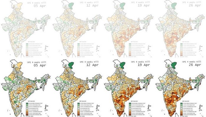
The measure that we are piloting is not based on the cumulative totals, for each district during each week of monsoon 2017, but for how adequate the rainfall has been over each week. What does that mean? Maharashtra’s Konkan region receives over four times the amount of rainfall that Vidarbha does. This does not mean that Vidarbha is more ‘rain poor’ than Konkan Maharashtra. The two meteorological regions are different just as their agro-ecologies, soils, water retention structures and flora are different.

Because of this difference, it is more useful to us to judge how adequate rainfall has been over any given period of measurement. We have taken a week because that is what we have data for, as provided by the Department of Hydrometeorology or the Department of Agricultural Meteorology of the India Meteorological Department, Ministry of Earth Sciences.

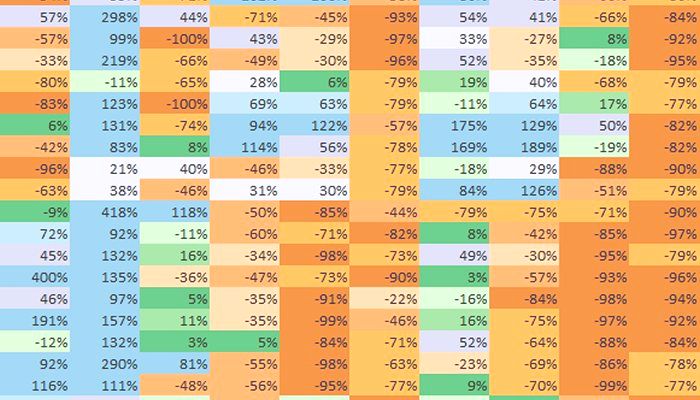
If you examine the cumulative totals – this means the running totals which from one week to the next carry over extras or deficits – the picture is as follows. One district only (Mumbai City) of the seven in Konkan Maharashtra is deficit (with -22%), all the rest being ‘normal’ in the range of -19% to +22%. The cumulative measurement picture for Vidarbha is this: only four out of the 11 districts (Buldana, Gadchiroli, Nagpur and Wardha) are ‘normal’ and in the range of -15% to -19%. The remaining seven are ‘deficit’ in the range of -23% to -36% (Amravati and Yavatmal being the lowest).

The weakness of the cumulative measure is that it ‘carries forward’ deficits and surpluses. A deficit in weeks 3 and 4 can be ‘made up’ for by better rains in week 5 and 6. But when rain in weeks 3 and 4 are important for a particular phase of a crop’s growth, the surplus that follows is of little use.

That’s where this pilot measure, what I have called the ‘rainfall adequacy index’, comes in. It indexes normalcy and variation from normalcy, plus or minus, and so records how adequate every week has been for the district. Using this method, we find that among Maharashtra’s meteorological regions, it is Vidarbha that has done best over 1 June to 9 August, followed by Konkan Maharashtra, then by Madhya Maharashtra and with Marathwada last.

The footnote is that the three districts with the best ‘rainfall adequacy index’ over this period are, in order, Sindhudurg, Nagpur and Wardha. The three districts with the worst index are Osmanabad, Nashik and both Thane and Palghar.

– Rahul Goswami

Filed Under: Latest, Monsoon 2017 Tagged With: 2017, agriculture, district, ecology, hydrometeorology, India, Konkan, Madhya Maharashtra, Maharashtra, Marathwada, monsoon, Mumbai, rainfall, Vidarbha, water

Dry districts alert, May 2017

May 1, 2017 by Climate portal editor Leave a Comment

A large number of districts in south, peninsular, central and eastern India are experiencing dry and semi-arid conditions which will continue, and likely become worse, until the 2017 monsoon becomes active.

This list of districts is based on our re-working of the maps released weekly by the India Meteorological Department (Hydromet section in Pune), which show the district-level standardised precipitation index (or SPI). While this is not a drought or dryness index, the weekly SPI serves as a very reliable indicator of where water stress is occurring, and is therefore an invaluable aid for relief planning.

In this series of four maps, re-coloured by us to better display differences in SPI between regions and over time, the change in south India stands out.

Each map displays the SPI as a cumulative reading of the four weeks until the date given. That is why the change for any district – from ‘moderately dry’ to ‘severely dry’ for example – needs to be seen as having an immediate bearing on the available water, crop health and condition of forest and pasture for that district.

Based on the readings for 26 April 2017 this is the list of districts that need urgent attention.

Maharashtra: Gadchiroli, Chandrapur, Yavatmal, Kolhapur
Chhattisgarh (Raipur division): Gariaband, Raipur, Baloda Bazar
Odisha: Rayagada, Kandhamal, Angul, Cuttack
West Bengal: 24 Parganas North
Manipur: Chandel
Andhra Pradesh: Vizianagaram, Kurnool
Telengana (old district boundaries): Nizamabad, Karimnagar, Medak, Warangal, Khammam, Mahbubnagar
Karnataka: Bidar, Raichur, Bijapur, Bagalkot, Koppal, Gadag, Dharwad, Bellary, Shimoga
Tamil Nadu: Cuddalore, Nagapattinam, Tiruvarur, Thanjavur, Pudukkottai, Ramanathapuram, Toothukudi, Kaniyakumari, Theni, Coimbatore
Kerala: Malappuram, Thrissur, Ernakulam, Kottayam, Alapuzha

Filed Under: Latest Tagged With: 2017, Andhra Pradesh, arid, Bharat, district, drought, India, Karnataka, Kerala, Maharashtra, Odisha, summer, Tamil Nadu, Telengana, water

From space, a district and its water

October 9, 2015 by Climate portal editor 3 Comments

RG_ICP_water_district_map_201510

In this panel of maps the relationship between the district of Parbhani (in the Marathwada region of Maharashtra) and water is graphically depicted over time. The blue squares are water bodies, as seen by a satellite equipped to do so. The intensity of the blue colour denotes how much water is standing in that coloured square by volume – the deeper the blue, the more the water.

Water bodies consist of all surface water bodies and these are: reservoirs, irrigation tanks, lakes, ponds, and rivers or streams. There will be variation in the spatial dimensions of these water bodies depending on how much rainfall the district has recorded, and how the collected water has been used during the season and year. In addition to these surface water bodies, there are other areas representing water surface that may appear, such as due to flood inundations, depressions in flood plains, standing water in rice crop areas during transplantation stages. Other than medium and large reservoirs, these water features are treated as seasonal and some may exist for only a few weeks.

RG_ICP_water_district_map_201510_section

Click for a section of the full size image. The detail can be mapped to panchayat level.

The importance of monitoring water collection and use at this scale can be illustrated through a very brief outline of Parbhani. The district has 830 inhabited villages distributed through nine tehsils that together occupy 6,214 square kilometres, eight towns, 359,784 households in which a population of 1.83 million live (1.26 rural and 0.56 million urban). This population includes 317,000 agricultural labourers and 295,000 cultivators – thus water use and rainfall is of very great importance for this district, and indeed for the many like it all over India.

This water bodies map for Parbhani district is composed of 18 panels that are identical spatially – that is, centred on the district – and display the chronological progression of water accumulation or withdrawal. Each panel is a 15-day period, and the series of mapped fortnights begins on 1 January 2015.

The panels tell us that there are periods before the typical monsoon season (1 June to 30 September) when the accumulation of water in surface water bodies has been more than those 15-day periods found during the monsoon season. See in particular the first and second fortnights of March, and the first fortnight of April.

During the monsoon months, it is only the two fortnights of June in which the accumulation of water in the surface water bodies of Parbhani district can be seen. The first half of July and the second half of August in particular have been recorded as relatively dry.

This small demonstration of the value of such information, provided at no cost and placed in the public domain, is based on the programme ‘Satellite derived Information on Water Bodies Area (WBA) and Water Bodies Fraction (WBF)’ which is provided by the National Remote Sensing Centre (NRSC), Indian Space Research Organisation (ISRO), Department of Space, Government of India.

For any of our districts, such continuous monitoring is an invaluable aid to: facilitate the study of water surface dynamics in river basins and watersheds; analyse the relationships between regional rainfall scenarios and the collection and utilisation of water in major, medium reservoirs and irrigation tanks and ponds; inventory, map and administer the use of surface water area at frequent intervals, especially during the crop calendar applicable to district and agro-ecological zones.

Filed Under: Blogs, Monsoon 2015 Tagged With: agriculture, district, ISRO, Maharashtra, monsoon, NRSC, rain, remote sensing, reservoir, river, rural, space, town, urban, village, water

Celsius surprises in 57 cities

May 21, 2015 by Climate portal editor Leave a Comment

ICP_57_cities_temp_top

The middle of February is when the chill begins to abate. The middle of May is when the monsoon is longed for. In our towns, district headquarters and cities, that climatic journey of 90 days is one of a steady rise in the reading of the temperature gauge, from the low 20s to the mid 30s.

This large panel of 90 days of daily average temperatures shows, in 57 ways, the effects of the rains that almost every district has experienced during the last two months. For each city, the curved line is the long period ‘normal’ for these 90 days, based on daily averages. Also for each city, the second line which swings above and below the ‘normal’ is the one that describes the changes in its daily average from February to May 2015.

[You can download (1.52MB) a full resolution image of the panel here.]

Where this second line crosses to rise above the normal, the intervening space is red, where it dips below is coloured blue. The patches of red or blue are what tell us about the effects of a lingering winter, or rains that have been called ‘unseasonal’ but which we think signal a shift in the monsoon patterns.

Amongst the readings there is to be found some general similarities and also some individual peculiarities. Overall, there are more blue patches than there are red ones, and that describes how most of the cities in this panel have escaped (till this point) the typical heat of April and May. The second noteworthy general finding is that these blue patches occur more frequently in the second half of the 90 days, and so are the result of the rainy spells experienced from March to early May.

Hisar (in Haryana) has remained under the normal temperature line for many more days than above or near it. So have Gorakhpur (Uttar Pradesh), Pendra (Chhattisgarh), Ranchi (Jharkhand), Nagpur (Maharashtra) and Jharsuguda (Odisha).

On the other hand in peninsular and south India, the below ‘normal’ daily average temperature readings are to be found in the latter half of the time period, coinciding with the frequent wet spells. This we can see in Kakinada, Kurnool and Anantapur (Andhra Pradesh), Bangalore, Gadag and Mangalore (Karnataka), Chennai, Cuddalore and Tiruchirapalli (Tamil Nadu) and Thiruvananthapuram (Kerala). [A zip file with the charts for all 57 cities is available here (1.2MB).]

What pattern will the next 30 days worth of temperature readings follow? In four weeks we will update this bird’s eye view of city temperatures, by which time monsoon 2015 should continue to give us more blues than reds. [Temperature time series plots are courtesy the NOAA Center for Weather and Climate Prediction.]

Filed Under: Current, Monsoon 2015, Reports & Comment Tagged With: Anantapur, Andhra Pradesh, Bangalore, Chennai, Chhattisgarh, city, climate, Cuddalore, Gadag, Gorakhpur, India, Jharkhand, Jharsuguda, Kakinada, Karnataka, Kerala, Kurnool, Maharashtra, Mangalore, monsoon, Nagpur, Odisha, Ranchi, Tamil Nadu, temperature, Thiruvananthapuram, Tiruchirapalli, town, urban, Uttar Pradesh

Deadly negligence

August 4, 2014 by Climate portal editor Leave a Comment

A resident looks at the debris of her damaged house after a landslide at Malin village, Pune district, in Maharashtra on 30 July 2014. Photo: Reuters/Stringer

A resident looks at the debris of her damaged house after a landslide at Malin village, Pune district, in Maharashtra on 30 July 2014. Photo: Reuters/Stringer

Two months of monsoon that have delivered rainfall considerably below normal have given way to an end July and early August that has brought torrents of rain in some locations, and with it destruction and the loss of life.

In the last week, there has been a landslide in the Pune district, western Maharashtra, in which the death toll has risen to over 100. There has been a landslide in Nepal, along the Bhote Kosi river, around 120 kilometres from Kathmandu, which is reported to have killed over 100 and displaced thousands. The situation there has led to an emergency in north Bihar, through which the Kosi flows, with some 65,000 people being evacuated from nine districts.

In the Bay of Bengal, 40 trawlers are reported to have gone missing in bad weather; there are estimated to be some 650 fishermen on board the vessels. In the Munshiganj district of central Bangladesh, about 40 kilometres from Dhaka, a ferry on the Padma river sank with about 200 on board.

Every one of these events is repeated every monsoon – landslide, flood, river ferry sinking, fishing trawlers missing at sea – with little indication that learning takes place about how to contain the impacts and how to prepare for them when they become threats.

The threat from the Kosi developed after a massive landslide blocked the main course of Bhote Kosi river, a tributary of the Kosi, in Sindhupalchok district of Nepal. The landslide brought down rock which has dammed the river, immediately forming a large lake. Authorities in Nepal have been trying to release the water without endangering downstream regions.

The central government has said (o4 August Monday) that there is no immediate threat of a flood. India’s Home Ministry, the Nepal Water Commission, India’s Central Water Commission and India’s National Crisis Management Committee are coordinating preparations, relief and technical expertise. The Bihar state government is carrying our the evactuations to avoid a situation like 2008, when a breach in the Kosi embankment at Kushaha in Nepal caused one of the most devastating floods.

The landslide in Nepal and the emergency in downstream Bihar has again revived the debate as to whether a dam would help solve the problem of floods in north Bihar. Since 1945 there have been commissions to study the problem and make their recommendations, and proposed dams have been abandoned for compelling reasons – that the river valleys have unstable foundations, that the region is a high-risk seismic zone, that the reservoirs would silt up far sooner than expected, and that the costs would be prohibitive.

The tragic incidents in Maharashtra, in the Bay of Bengal, and in Munshiganj (Bangladesh) have much more to do with the wilful neglect of conditions that have built up a cumulative threat. The landslide in Pune district which has buried portions of a village, its residents and cattle, was according to a number of media reports the result of factors that included what appears to be no recognition of the most obvious risks. The hill above the village of Malin is reported to have been the site of wind turbines (which need heavy machinery to erect them) and also farming that used heavy equipment to level the top of the hill. Whichever factor is true, the use to which hill land was put was a threat to the settlement at its base, and little thought was given to monsoon conditions.

That such a large group of trawlers went missing in the Bay of Bengal near Kakdwip in South 24 Parganas district of West Bengal has to do with economic reasons, which media reports will at this stage not uncover. Three of the trawlers are reported as having capsized and authorities in West Bengal are said to have ‘traced’ 25 of the vessels. The question is: when squally weather and forecasts of heavy rain trigger warning to fishermen, why do they ignore these warnings and risk their lives? The usual answer is loan economics, for the trawler owners can’t afford delays in servicing the loans with which they bought the vessels, and are under pressure to find and sell fish, which is when safety considerations are ignored.

Similar considerations lead in Bangladesh to riverine ferries – a common mode of transport in great deltas – being overloaded to far beyond their capacities. The monsoon brings with it weather conditions that demand safety first, but when economic desperation and plain greed set in, elementary precautions that are meant to save lives are discarded.

Filed Under: Latest, Monsoon 2014 Tagged With: Bangladesh, Bay of Bengal, Bihar, cyclone, disaster, evacuation, ferry, fishermen, flood, India, Kosi, land use, landslide, Maharashtra, monsoon, Nepal, rehabilitation, rescue, water

Unseasonal rain, hailstorms trigger farmers’ suicides in Maharashtra

March 22, 2014 by Climate portal editor Leave a Comment

Farmers' suicides in rural India now directly connected to weather-related events. When will state governments take protective measures? Photo: ICP / RG

Farmers’ suicides in rural India now directly connected to weather-related events. When will state governments take protective measures? Photo: ICP / RG

Following the recent bout of unseasonal showers and hailstorms in Maharashtra, sources working closely with the government have said that around 18 farmers have killed themselves between February 22 and March 18, social activists claim the figure could be between 80 and 100 — more than the average for every two months, as reported by The Times of India.

Meanwhile, Maharashtra’s chief minister, Prithviraj Chavan has assured farmers of the area that their plight will be immediately taken into account. He has also appealed to the farmers to not take any ’emotional step’ and has reiterated that the government is acutely aware of destruction that has been brought on by the untimely rain. The state cabinet has called an urgent meeting on Wednesday to discuss relief and rehabilitation for hailstorm-hit areas.

Meanwhile, Maharashtra’s chief minister, Prithviraj Chavan has assured farmers of the area that their plight will be immediately taken into account. He has also appealed to the farmers to not take any ’emotional step’ and has reiterated that the government is acutely aware of destruction that has been brought on by the untimely rain.

Kishor Tiwari, an activist claimed that around 100 farmers had committed suicides across Maharashtra following unseasonal showers and hailstorms. “The situation after the hailstorm is really damaging. Three days of hailstorm has completed damaged the crop of horsegram, wheat and jowar. Earlier bouts of unseasonal showers had damaged the soyabean crop. So it’s an irreparable loss to the farmers for which government help is too late and too little,” Tiwari said.

Filed Under: Current, Monsoon 2014 Tagged With: farmer, Maharashtra, rain, suicide

Indiaclimate twitter

Tweets by @Indiaclimate

Notable

Between contemplation and climate

Whether or not the USA, Europe, the Western world, the industrialised Eastern world (China, Japan, South Korea, Taiwan), adhere to or not their paltry promises about being more responsible concerning the factors that lead to climate change, is of very little concern to us. We have never set any store by international agreements on climate […]

The ‘Hindu’, ignorant about weather and climate, but runs down IMD

We find objectionable the report by ‘The Hindu’ daily newspaper accusing the India Meteorological Department of scientific shortcoming (‘IMD gets its August forecast wrong’, 1 September 2016). The report claims that the IMD in June 2016 had forecast that rains for August would be more than usual but that the recorded rain was less than […]

dialogue

  • Misreading monsoon | Resources Research on Misreading monsoon
  • Satish on A tribute to the weathermen of Bharat
  • Climate portal editor on A tribute to the weathermen of Bharat
  • Climate portal editor on A tribute to the weathermen of Bharat
  • Climate portal editor on A tribute to the weathermen of Bharat

Categories

Copyright © 2025 indiaclimateportal.org.