The India Climate Observatory

Commentary, action and research on climate and development in India

  • Home
  • About
  • Monsoon 2018
  • Current
  • Bulletin
  • Contact
  • Announcements

Rain for the Rani

July 2, 2017 by Climate portal editor Leave a Comment

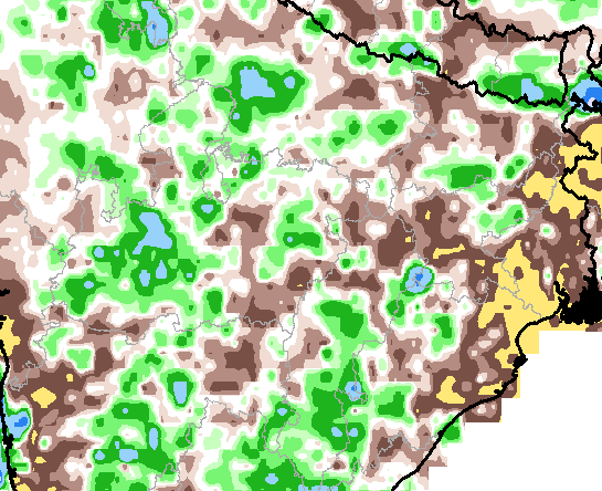
We find that the heavy rains that soaked the north Gujarat plains on the night of 1/2 July are testimony to the genius and far-sightedness of the builders of the Rani-ki-Vav, the famed stepwell which was initially built as a memorial to a king in the 11th century AD. The central heavy rainfall zone was immediately to the north-west of Patan, the town nearest to the Rani-ki-Vav, and it is precisely for this sort of rain that this fabulously constructed stepwell was built.


Rain for the Rani. At about 8pm on 1 July, dense rainclouds hung over the entire north #Gujarat plains, from ancient Dholavira to Dahod ..2

— Indiaclimate (@Indiaclimate) July 2, 2017


..by 8:30 pm showers were being reported from towns in the region while farther north in #Rajasthan, heavy rain pelted Barmer and Jalor ..3

— Indiaclimate (@Indiaclimate) July 2, 2017


..Rain for the Rani. At around 9pm the rainfall had become very heavy, reaching 15mm/hour, quickly leaching into the parched soil ..4 pic.twitter.com/zHLFHzcVmH

— Indiaclimate (@Indiaclimate) July 2, 2017


..The cores of two cloud masses were converging. The heavy rain was now on two parallel fronts each about 300 km wide ..5 pic.twitter.com/gamGJtCQGp

— Indiaclimate (@Indiaclimate) July 2, 2017


.. Rain for the Rani. At around midnight the Rajasthan and Gujarat core rainfall zones merged and the intensity lessened #monsoon2017 ..6 pic.twitter.com/MCpROK4jLo

— Indiaclimate (@Indiaclimate) July 2, 2017


..On the ground, about 2 km outside the old town of Patan, the water levels in an 11th century structure were rising. This remarkable ..7

— Indiaclimate (@Indiaclimate) July 2, 2017


..well, the Rani Ki Vav, was sited, designed, engineered and adorned exactly for rains such as this !! Town streets flooded and cars ..8 pic.twitter.com/sKD03C7sYp

— Indiaclimate (@Indiaclimate) July 2, 2017


..stalled. But the old channels & chambers of the Rani Ki Vav were proving the vision and sagacity of the celebrated stepwell’s creators ..9

— Indiaclimate (@Indiaclimate) July 2, 2017


..Designed as an inverted temple highlighting the sanctity of water, the Rani Ki Vav combines #water storage with exceptional artistry ..10 pic.twitter.com/CWxBh2cyW7

— Indiaclimate (@Indiaclimate) July 2, 2017


..We marvel at the foresight and knowledge of the Vav’s builders. To the north and north-west of the stepwell lay the zone in which this .11

— Indiaclimate (@Indiaclimate) July 2, 2017


..torrent of rain fell over 1/2 July, recharging the subterranean water storage system whose design origin is the 3rd millennium BC ..12 pic.twitter.com/wEWYyCRgnu

— Indiaclimate (@Indiaclimate) July 2, 2017


..This is the 4 hour 30 min sequence of intense #monsoon2017 rainfall in north #Gujarat and adjacent #Rajasthan – Rain for the Rani pic.twitter.com/zeuKb6SCZG

— Indiaclimate (@Indiaclimate) July 2, 2017

Filed Under: Monsoon 2017, Reports & Comment Tagged With: 2017, Gujarat, heritage, India, monsoon, rain, Rajasthan, stepwell, traditional knowledge, water

A typical June for the 2017 monsoon

June 24, 2017 by Climate portal editor Leave a Comment

Three weeks of rainfall during the ‘official’ monsoon (which both within meteorological circles and outside is still said to begin on 1 June) season, we are now able to present the week by week trend.

The graphic (click for full size image) shows the distribution of districts according to our expanded measure for rainfall adequacy. We call this expanded as it has 12 categories (11 plus ‘no data’) which we debuted in 2015.

To be used mainly as a planning and response indicator – such as preparing for the consequences of a dry spell or readying contingency plans if continued heavy rainfall make flooding a likelihood – our expanded measure also provides a weekly snapshot of rainfall at the district level. These snapshots, which in the graphic take the form of coloured horizontal bars, when stacked together give us a trend.

The indiaclimate visualisation of rainfall distribution by districts using our 12-grade category scale.

What we see from the bars that represent district rainfall distribution for three weeks is that the 2017 monsoon has for this period been what the India Meteorological Department first forecast in April, and then confirmed in May: that this year’s monsoon will be normal.

In each horizontal bar the most important category is the one marked “+10% to -10%” as this is the ‘core’ normal range of 10% above and below the long-term average. Since our time-frame for each snapshot is one week, this means the long-term average rainfall for a district for that week. Next in importance are the two categories that follow, above and below. These are the “-11% to -20%” and “+11% to +20%” and may be interpreted as satisfactory.

Thus we see that for the week ending 07 June (the lowest bar) 41 districts recorded normal rainfall for that week, 22 recorded satisfactory (but below normal) and 15 recorded satisfactory (but above normal). The similar distribution the following week, that is ending 14 June and the middle bar, was 39, 26 and 11. And the distribution for the latest week, that is ending 21 June and the top bar, is 61, 35 and 21.

However as the monsoon has weakened over the last few days and may not regain its customary vigour for this time of the year until 27 or 28 June, we expect our next instalment to show more districts in the browner shades towards the left of the categories bar.

You can follow our monsoon data, graphics and commentary on both our website and twitter channel.

Filed Under: Latest, Monsoon 2017 Tagged With: 2017, India, monsoon, rain, trend

Between contemplation and climate

June 8, 2017 by Climate portal editor Leave a Comment

Whether or not the USA, Europe, the Western world, the industrialised Eastern world (China, Japan, South Korea, Taiwan), adhere to or not their paltry promises about being more responsible concerning the factors that lead to climate change, is of very little concern to us. We have never set any store by international agreements on climate change.

This year will see the twenty-third conference of parties of the UN Framework Convention on Climate Change and for 23 years the world and India have listened to lofty tales about simple science. In these 23 years, neither has reckless consumption been halted nor has the economic model that encourages such reckless consumption been questioned by the conference of parties. As long as they do not, inter-governmental agreements are useless.

That is why we find unnecessary and pointless the hand-wringing that has taken place about the decision of the government of the USA to exit what is called the ‘Paris Agreement’, the December 2015 document agreed to and signed by practically every country which has some fuzzy paragraphs about low-carbon economy, innovation, technology, energy and finance – all of which have very much to do with the hold of the finance capitalists and the global technocrats over the international systems of our time.

President number 45 of the USA is neither wiser than nor baser than the wisest of basest of any of his predecessors: the American political system has to do entirely with the desire to dominate other countries. Number 45’s manner may be irksome, but through him speaks the American finance capital, its bloatsome defence industry and its insensate technology industry.

We do not expect the chiefs of the Western countries, the so-called major powers of the European Union, and their allies such as Japan and Australia to do any less. They are no different. We do not think any of them, their armies of bland advisers, their bankers and the brigades of industrialists great and petty who crowd their corridors of governance have read, much less reflected, on the lambent wisdom of our civilisation.

Many centuries ago, in the section of the Digha Nikaya, or Collection of Long Discourses, called Samannaphala Sutta, or the Fruits of the Contemplative Life, it was written that there are those who are addicted to debates and shout: “You understand this doctrine and discipline? I’m the one who understands this doctrine and discipline. How could you understand this doctrine and discipline? You’re practicing wrongly. I’m practicing rightly. I’m being consistent. You’re not. What should be said first you said last. What should be said last you said first. What you took so long to think out has been refuted. Your doctrine has been overthrown. You’re defeated. Go and try to salvage your doctrine; extricate yourself if you can!”

And this is how we view what are called climate negotiations, between the experts of countries. We care not for the arguments of number 45 of the USA, for what many in the world in the last week have protested as being absurd – it undermines economy, it takes away jobs, it is unfair, it is disadvantageous to us, and so on – is what they cheer and support their own countries for in areas where they stand to gain, such as trade (to sell cheap and useless goods), technology (to enslave and control), finance (to spin webs of debt), processes of modernisation (to homogenise cultures so that ever more ‘markets’ come into being).

We in India need no such instruction. But we must guard against our philosophies being swept away by these agreements, these grand comities of nations, the barrage of numerics and scientifics that are invented to display to us what a threat we are should we not emulate the West and its ways. We must guard against our own who prefer the baubles of post-industrial society to the intellectual and spiritual riches of our civilisation, and who seek to infest India with the same technological and ‘modern’ wares that so entranced the West and doomed its folk. This has very little to do with climate and its change and very much more to do with our Indic sciences and their worth, our conduct and our duty to Punyabhoomi Bharat.

– Rahul Goswami

Filed Under: Blogs Tagged With: Bharat, civilisation, climate, Climate Change, convention, Europe, finance, India, Paris accord, Paris agreement, philosophy, technology, UN, UNFCCC, USA

Dry districts alert, May 2017

May 1, 2017 by Climate portal editor Leave a Comment

A large number of districts in south, peninsular, central and eastern India are experiencing dry and semi-arid conditions which will continue, and likely become worse, until the 2017 monsoon becomes active.

This list of districts is based on our re-working of the maps released weekly by the India Meteorological Department (Hydromet section in Pune), which show the district-level standardised precipitation index (or SPI). While this is not a drought or dryness index, the weekly SPI serves as a very reliable indicator of where water stress is occurring, and is therefore an invaluable aid for relief planning.

In this series of four maps, re-coloured by us to better display differences in SPI between regions and over time, the change in south India stands out.

Each map displays the SPI as a cumulative reading of the four weeks until the date given. That is why the change for any district – from ‘moderately dry’ to ‘severely dry’ for example – needs to be seen as having an immediate bearing on the available water, crop health and condition of forest and pasture for that district.

Based on the readings for 26 April 2017 this is the list of districts that need urgent attention.

Maharashtra: Gadchiroli, Chandrapur, Yavatmal, Kolhapur
Chhattisgarh (Raipur division): Gariaband, Raipur, Baloda Bazar
Odisha: Rayagada, Kandhamal, Angul, Cuttack
West Bengal: 24 Parganas North
Manipur: Chandel
Andhra Pradesh: Vizianagaram, Kurnool
Telengana (old district boundaries): Nizamabad, Karimnagar, Medak, Warangal, Khammam, Mahbubnagar
Karnataka: Bidar, Raichur, Bijapur, Bagalkot, Koppal, Gadag, Dharwad, Bellary, Shimoga
Tamil Nadu: Cuddalore, Nagapattinam, Tiruvarur, Thanjavur, Pudukkottai, Ramanathapuram, Toothukudi, Kaniyakumari, Theni, Coimbatore
Kerala: Malappuram, Thrissur, Ernakulam, Kottayam, Alapuzha

Filed Under: Latest Tagged With: 2017, Andhra Pradesh, arid, Bharat, district, drought, India, Karnataka, Kerala, Maharashtra, Odisha, summer, Tamil Nadu, Telengana, water

Big water storage wheel

April 29, 2017 by Climate portal editor Leave a Comment

The Central Water Commission, Ministry of Water Resources, Government of India, monitors every day the quantity of water stored (and used from) each of the 91 major reservoirs of the country. It issues a bulletin every week that gives the weekly storage position of these reservoirs – the volume of water, the level of water in the reservoir and the change from the last week, the change from the same date last year and from the average on this date of the last ten years.

The water storage capacity of these 91 reservoirs taken together is 157.799 billion cubic metres (bcm) which is estimated to be about 62% of the total water storage capacity (in other smaller dams and storage structures all over the country) that has been built and is being used, and which is approximately 253.38 bcm. Out of these 91 reservoirs, hydro-electric power stations (with a capacity of 60 megawatts and more) are attached to 37 reservoirs.

In this illustration by Indiaclimate, for the first time the total storage capacity of the 91 major reservoirs has been visually mapped to show reservoir, state and zone capacities relative to each other and the total.

These are the reservoirs with state, reservoir name and full reservoir level in billion cubic metres (bcm). For a good quality file that you can print, write to us.

South zone reservoirs (AP for Andhra Pradesh, TG for Telengana, APTG for Andhra Pradesh and Telegana together, KAR for Karnataka, TN for Tamil Nadu, KER for Kerala): AP, Somasila (1.994); TG, Sriramsagar (2.3); TG, Lower Manair (0.621); APTG, Srisailam (8.288); APTG, Nagarjuna Sagar (6.841); KAR, Krishnaraja Sagra  (1.163); KAR, Tungabhadra (3.276); KAR, Ghataprabha (1.391); KAR, Bhadra (1.785); KAR, Linganamakki (4.294); KAR, Narayanpur (0.863); KAR, Malaprabha (Renuka) (0.972); KAR, Kabini (0.444); KAR, Hemavathy (0.927); KAR, Harangi (0.22); KAR, Supa (4.12); KAR, Vanivilas Sagar (0.802); KAR, Almatti (3.105); KAR, Gerusoppa (0.13); KER, Kallada (Parappar) (0.507); KER, Idamalayar (1.018); KER, Idukki (1.46); KER, Kakki (0.447); KER, Periyar (0.173); KER, Malapmuzha (0.224); TN, Lower Bhawani (0.792); TN, Mettur (Stanley) (2.647); TN, Vaigai (0.172); TN, Parambikulam (0.38); TN, Aliyar (0.095); TN, Sholayar (0.143). Total for 31 reservoirs 51.59 bcm

West zone reservoirs (GUJ for Gujarat, MAH for Maharashtra): GUJ, Ukai (6.615); GUJ, Sabarmati (Dharoi) (0.735); GUJ, Kadana (1.472); GUJ, Shetrunji (0.3); GUJ, Bhadar (0.188); GUJ, Damanaganga (0.502); GUJ, Dantiwada (0.399); GUJ, Panam (0.697); GUJ, Sardar Sarovar (1.566); GUJ, Karjan (0.523); MAH, Jayakwadi (Paithon) (2.171); MAH, Koyana (2.652); MAH, Bhima (Ujjani) (1.517); MAH, Isapur (0.965); MAH, Mula (0.609); MAH, Yeldari (0.809); MAH, Girna (0.524); MAH, Khadakvasla (0.056); MAH, Upper Vaitarna (0.331); MAH, Upper Tapi (0.255); MAH, Pench (Totaladoh) (1.091); MAH, Upper Wardha (0.564); MAH, Bhatsa (0.942); MAH, Dhom (0.331); MAH, Dudhganga (0.664); MAH, Manikdoh (Kukadi) (0.288); MAH, Bhandardara (0.304). Total for 27 reservoirs 27.07 bcm

East zone reservoirs (JHR for Jharkhand, ODI for Odisha, WB for West Bengal, TRI for Tripura): JHR, Tenughat (0.821); JHR, Maithon (0.471); JHR, Panchet Hill (0.184); JHR, Konar (0.176); JHR, Tilaiya (0.142); ODI, Hirakud (5.378); ODI, Balimela (2.676); ODI, Salanadi (0.558); ODI, Rengali (3.432); ODI, Machkund (Jalput) (0.893); ODI, Upper Kolab (0.935); ODI, Upper Indravati (1.456); WB, Mayurakshi (0.48); WB, Kangsabati (0.914); TRI, Gumti (0.312). Total for 15 reservoirs 18.83 bcm

Central zone reservoirs (UP for Uttar Pradesh, UTT for Uttarakhand, MP for Madhya Pradesh, CHT for Chhattisgarh): UP, Matatila (0.707); UP, Rihand (5.649); UTT, Ramganga (2.196); UTT, Tehri (2.615); MP, Gandhi Sagar (6.827); MP, Tawa (1.944); MP, Bargi (3.18); MP, Bansagar (5.166); MP, Indira Sagar (9.745); MP, Barna (0.456); CHT, Minimata Bangoi (3.046); CHT, Mahanadi (0.767). Total for 12 reservoirs 42.30 bcm

North zone reservoirs (HP for Himachal Pradesh, PUN for Punjab, RAJ for Rajasthan): HP, Gobind Sagar (Bhakra) (6.229); HP, Pong Dam (6.157); PUN, Thein  (2.344); RAJ, Mahi Bajaj Sagar (1.711); RAJ, Jhakam (0.132); RAJ, Rana Pratap Sagar (1.436). Total for 6 reservoirs 18.01 bcm

Filed Under: Current Tagged With: agriculture, Bharat, dam, drinking water, hydel, hydro, India, irrigation, reservoir, water, water pump, water resources, water storage

South India’s water emergency

April 11, 2017 by Climate portal editor Leave a Comment

ICP_res_20170410_top
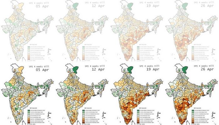
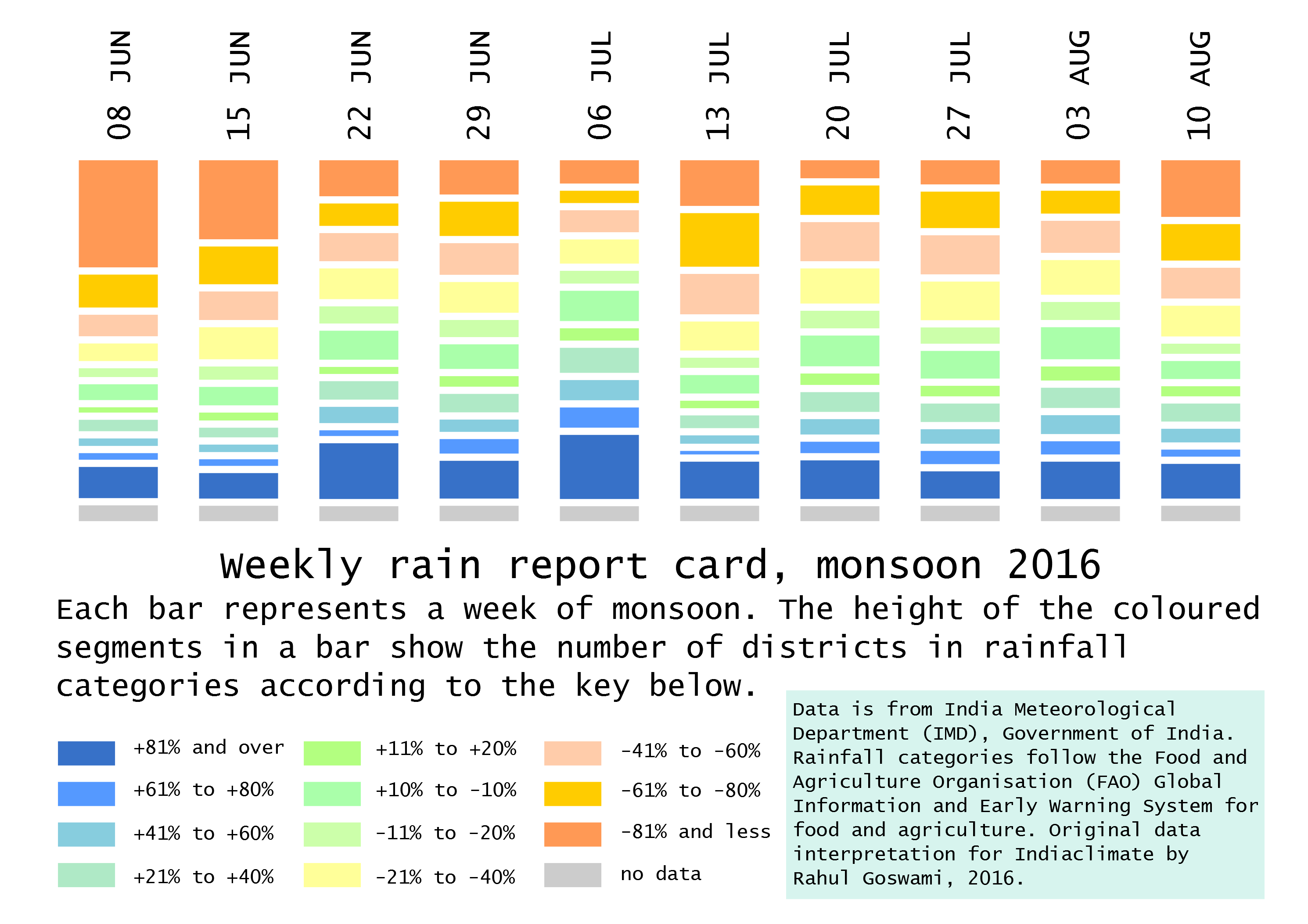
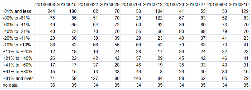
By the end of the first week of April 2017, the most current and reliable indicator for stored water in south India showed how dire the situation has become. And the South-West monsoon is still about eight weeks away. The weekly data sheet on the stored water quantities in the 91 major reservoirs of India, which is maintained and released by the Central Water Commission, has in the 6 April 2017 release shown the scale of the water emergency.

Of the 31 reservoirs in the southern region (Kerala, Tamil Nadu, Karnataka, Telengana and Andhra Pradesh) that are among the major reservoirs of India, 18 have stored water that is less than 15% of their full capacities.

These 18 are (ranked by least water stored):
Nagarjuna Sagar, APTG, 0.00%
Sholayar, TN, 0.00%
Almatti, KAR, 0.03%
Kabini, KAR, 2.25%
Vanivilas Sagar, KAR, 2.74%
Tungabhadra, KAR, 3.21%
Vaigai, TN, 4.07%
Parambikulam, TN, 5.00%
Malaprabha (Renuka), KAR, 5.56%
Hemavathy, KAR, 5.72%
Mettur (Stanley), TN, 6.72%
Periyar, KER, 6.94%
Bhadra, KAR, 9.02%
Lower Bhawani, TN, 9.09%
Srisailam, APTG, 9.44%
Krishnaraja Sagar, KAR, 11.44%
Malapmuzha, KER, 11.61%
Aliyar, TN, 14.74%
(TN is Tamil Nadu, KER is Kerala, KAR is Karnataka, APTG is Andhra Pradesh and Telengana)

ICP_south_water_20170411

Using a municipal average of about 400 litres per day per household that is a typical designed supply (not delivered, for that’s another tale), how much water does this allow for the 60.51 million households of the southern region until the monsoon begins?

Tamil Nadu has 18.46 million households, Kerala has 7.83 million, Karnataka has 13.3 million, Andhra Pradesh and Telengana have 20.92 million. These together need 24.2 billion litres a day or, in reservoir storage terms, 0.024 billion cubic metres (bcm) a day. The 31 major reservoirs of southern India together have, as of 6 April 2017, 6.583 bcm. From this quantity is taken water for industrial, agricultural and commercial use.

These uses are given priority or water stocks are secured (never mind allocation and metering) especially by industry. Normally, what remains for household use is about a third of the available stock. This leaves, as on 6 April, about 2.19 bcm for household use, which will suffice the 60.51 million households of south India for about 90 days – but only provided, and this is the stringent, non-negotiable condition that must be enforced, all households especially urban keep within the 400 litres per household per day limit.

The situation does not improve even if the monsoon arrives on time and the first weeks deliver normal rainfall. It is only by July 5-15 that reservoir water stocks begin trending upwards. This is where the 90-day restricted supply can take south India to. But only if immediate and strict rationing is imposed, as it should have been, to allow for climatological variance, by 1 March 2017.

Filed Under: Latest Tagged With: Andhra Pradesh, Bharat, drought, India, Karnataka, Kerala, reservoir, Tamil Nadu, Telengana, water, water shortage, water supply

The ‘Hindu’, ignorant about weather and climate, but runs down IMD

September 2, 2016 by Climate portal editor Leave a Comment

ICP_IMD_Hindu_comment_20160901

We find objectionable the report by ‘The Hindu’ daily newspaper accusing the India Meteorological Department of scientific shortcoming (‘IMD gets its August forecast wrong’, 1 September 2016). The report claims that the IMD in June 2016 had forecast that rains for August would be more than usual but that the recorded rain was less than usual.

This is nothing but cheap sensationalising by the newspaper of a non-issue. In so doing the ‘Hindu’, which is considered one of Bharat’s national newspapers, has attempted to tarnish the work of not only the India Meteorological Department, but also the work of the earth observation technical community which serve us in the several institutions and agencies of the Ministry of Earth Sciences.

There is no mainstream news media in the country – no daily newspapers, no magazine or periodical, no television channel, no internet website – which possesses the competence to assess the scientific quality and correctness of output of the government earth science agencies, and whose output is delivered to the public every day, several times a day. ‘The Hindu’ certainly does not and with this report exposes its ignorance about meteorology and climate science and observation.

Concerning the newspaper’s claim, rainfall for the period 1 June to 31 August in the 36 meteorological sub-divisions of Bharat, as an area-weighted average, is -3% of the long period average and is therefore well within the boundaries set by both the first stage and second stage forecasts provided by the IMD. Of the 36 sub-divisions, for this period 24 sub-divisions have recorded normal rainfall, four have excess and eight (including the two island sub-divisions) have deficient rainfall. In what way is this an erring forecast?

The news report in the ‘Hindu’ states that the forecasting error it has found “suggests that the agency’s weather models are still not robust enough to capture changes in global climate that could affect” our monsoon. This is nonsense.

The earth observation agencies of the MoES – of which the IMD is a part – for the June to September monsoon forecast employs a group of six parameters that inform the forecast (together called an ensemble forecasting system). These are: north-east Pacific to north-west Atlantic sea surface temperature anomaly gradient, south-east equatorial Indian Ocean sea surface temperature, East Asia mean sea level pressure, central Pacific (El Nino region 3.4), sea surface temperature and tendency, north Atlantic mean sea level pressure and north-central Pacific 850mb wind gradient. In what way does this not look at global climate?

Moreover, the IMD and the agencies of the MoES (notably the Indian Institute of Tropical Meteorology) work closely regionally and internationally on climate science, weather prediction and monitoring. Not only is the IMD implementing for the World Meteorological Organisation (WMO) a Regional Climate Centre for South Asia, the monsoon prediction and monitoring system relies on collaboration with: the National Centers for Environmental Prediction (NCEP) of USA, the European Centre for Medium-Range Weather Forecasts (ECMWF), the Japan Meteorological Agency (JMA), the Met Office Hadley Centre for Climate Science and Services of UK, and with the national meteorological agencies of Bangladesh, Bhutan, the Maldives, Myanmar, Nepal, Pakistan, and Sri Lanka.

And furthermore, it is because the Earth System Science Organisation agencies and institutes revise, review and upgrade forecasting models, computing wherewithal and methods continuously that we have in 2016 an experimental forecast (based on the Monsoon Mission coupled dynamical model).

‘The Hindu’ newspaper has presented its own uninformed reading of differences in forecast averages to make an absurd claim against the IMD, neglecting entirely to mention the extremely valuable service provided, at the district and even at the block level, to Bharat’s kisans via daily sms on weather which will affect crops; neglecting the several excellent initiatives launched by the Department since 2015 on localising forecasts for towns and cities (in close coordination with the National Remote Sensing Centre of the Indian Space Research organisation, the Meteorological and Oceanographic Satellite Data Archival Centre of ISRO’s Space Applications Centre, and the Indian National Centre for Ocean Information Services.

Filed Under: Blogs Tagged With: 2016, Bharat, forecast, IMD, India, monsoon, weather

Monsoon weekly report card 2016

August 18, 2016 by Climate portal editor Leave a Comment

ICP_district_rainweeks_20160818

Employing the modified rainfall measurement categories, we have prepared a ‘report card’ for ten weeks of rainfall beginning with the week 02-08 June and continuing until the most recent which is the week of 04-10 August. This ‘report card’ is based on the recorded rainfall for each district and how much it varies from the normal for that particular week. This variation is portrayed by our ‘report card’ through the modified categories, which are designed to show more finely not merely deficient or excess rainfall, as the current categories do, but the degree of deficiencies or excesses for that district, for that week.

ICP_RG_2016_district_10rainweeks_20160818

Our indicator of eleven grades (compared with the four of the India Meteorological Department, IMD) uses the same weekly district data to provide greater detail about rainfall adequacy or lack. Using this method we can immediately see from the chart:

1. From the week ending 22 June there have been a large number of districts – between 20% and 40% of all districts for which data is available – included in the four categories that describe rainfall of +20% above the normal.

2. That notwithstanding the overall seasonal prediction of monsoon 2016 having thus far been proved correct, there are almost every week a sizeable number of districts falling in the three categories for deficient rainfall.

3. That for the ten weeks in our report card the number of districts in the -21% to -40% below normal band is greater than the number of districts in the band for +21% to +40%.

ICP_district_rainweeks_table_20160818

In the chart, each bar corresponds to a week of district rainfall readings, and that week of readings is split into eleven grades (plus one for no data). In this way, the tendency for administrations, citizens, the media and all those who must manage natural resources (particularly our farmers), to think in terms of an overall ‘deficit’ or an overall ‘surplus’ is halted.

We find that our modified rainfall categories are more informative at the district level – and therefore cumulatively at the state and meteorological sub-division levels too  – and can readily be adopted by administrations and planners.

In today’s concerns that have to do with the impacts of climate change, with the increasing variability of the monsoon season, and especially with the production of food crops, the IMD’s stock measurement – ‘normal’ is rainfall up to +19% above a given period’s average and also down to -19% from that same average, ‘excess’ is +20% rain and more, ‘deficient’ is -20% to -59% and ‘scanty’ is -60% to -99% – is no longer viable.

Filed Under: Latest, Monsoon 2016 Tagged With: 2016, district, IMD, India, monsoon

Heavy rain alert for Bihar, Uttar Pradesh

July 19, 2016 by Climate portal editor Leave a Comment

ICP_UP_BIH_20160719

Heavy and very heavy rainfall is expected today 19 July and until 22 July in Bihar, eastern Uttar Pradesh and sub-Himalayan West Bengal. The India Meteorological Department has issued a heavy rainfall alert for these regions.

These are the districts which will be the most affected:
In Bihar – Paschim Champaran, Gopalganj, Purbi Champaran, Siwan, Chhapra, Muzaffarpur, Sitamarhi, Madhubani, Darbhanga, Supaul, Saharsa, Madhepura, Purnia, Katihar, Kishanganj, Araria.
In Uttar Pradesh – Pilibhit, Shahjahanpur, Kheri, Hardoi, Sitapur, Shrawasti, Bahraich, Gonda, Balrampur, Basti, Sidharthnagar, Sant Kabir Nagar, Gorakhpur, Deoria, Maharajganj, Kushinagar.

ICP_ncmrwf_UP_bihar_20160719

These are the five river sub-basins of the Ganga basin which are affected:
Gomti – including the Kathna, Sarayan, Kalyani rivers. Cities in this sub-basin – Sitapur, Hardoi, Lucknow, Rae Bareli, Sultanpur, Jaunpur.
Ghaghara – including the Saryu, Rapti, Chhoti Gandak rivers. Cities in this sub-basin – Lakhimpur, Shrawasti, Gonda, Faizabad, Basti, Gorakhpur, Kushinagar, Deoria, Siwan, Ballia.
Ghaghara confluence to Gomti confluence – including Chhoti Saryu and Mangal rivers. Cities in this sub-basin – Faizabad, Nizamabad, Azamgarh, Mau, Ghazipur, Buxar, Bhojpur, Chandauli.
Kosi – including Kamala, Pipra, Dhemra rivers. Cities in this sub-basin – Sheohar, Sitamarhi, Darbhanga, Supaul, Madhepura, Saharsa, Kishanganj, Khagaria.
Bhagirathi – including Fariyani Nadi and Kamla rivers. Cities in this sub-basin – Araria, Purnia, Sahibganj, Malda (West Bengal).

In the Middle Ganga plains, the water drainage lines govern the human occupancy of land, particularly the agricultural land and settlements. The rivers meet at acute angles and several tributaries form parallel or sub-parallel lines to the main stream. The major rivers that meet the main stream in the middle plain are the Gandak, the Kosi, the Sone and other small tributaries of Ganga like the Tons, the Karmansa, the Chatar, the Jargo, the Karnauti, the Khejuri on the west of the Sone and those on the east of the Sone are the Punpun, the Mohini and the Chandan.

Floods are recurring feature in this region particularly in the North Ganga plains. Almost all rivers in this middle plain develop a capacity to spill over in the monsoon period and are notoriously dynamic in character, particularly the Rapti, the Ghaghara, the Gandak, the Kosi, the Sone and the main Ganga itself.

Filed Under: Latest, Monsoon 2016 Tagged With: 2016, basin, Bihar, flood, Ganga, India, monsoon, rain, Uttar Pradesh

Rivers before states

June 29, 2016 by Climate portal editor Leave a Comment

2016-06-29_192703

Our view of where water falls during the monsoon and where it is used has tended to follow the administrative unit view. That is, which state has experienced normal, above normal or deficient rainfall or which meteorological division has experienced normal, above normal or deficient rainfall.

Such a view has obscured an important ground reality, and this is that when it rains, surface water follows the contours and topography of watersheds and third-level basins, themselves subsets of sub-basins and then river basins. Thus when rain falls, water collects and begins to flow, it is natural to look for where it flows and where it may be collected instead of whether it is measured on one side or another of an imaginary boundary, which is what a district or state boundary is.

Rainfall anomalies in millimetres for 01-26 June. Greens/blues are above, browns/ochres are below. This section which includes Maharashtra, Madhya Pradesh, Chhattisgarh, Jharkhand, Bihar, Uttar Pradesh and part of Rajasthan shows how deficient areas are interspersed with excess areas. Watersheds could be the answer. Image source: NCEP, CPC

Rainfall anomalies in millimetres for 01-26 June. Greens/blues are above, browns/ochres are below. This section which includes Maharashtra, Madhya Pradesh, Chhattisgarh, Jharkhand, Bihar, Uttar Pradesh and part of Rajasthan shows how deficient areas are interspersed with excess areas. Watersheds could be the answer. Image source: NCEP, CPC

For everything that concerns water – which does mean everything that is essential to us: agriculture, forests, grassy regions and orchards, water that can be used for drinking, rural and urban settlements, commerce and industry – it is the group of hydrological structures we call a river basin (or sub-basin if the basin is a large one) that becomes the spatial region to study and plan for.

We have 36 states and union territories and also 36 meteorological divisions. These correspond with each other for most of the country and this correspondence, unnecessary and misleading, has led to our incorrect view of where rain falls and how it behaves where it falls. It has been a persistent error because I think of administrative inertia combined with the quite needless politics that surrounds river (or surface) and ground water.

Rain falls upon and rainwater collects and moves surface water then not in a taluka or district, but in a biophysical region which in one way we can describe as a river sub-basin or a large watershed. There are other pieces that make the whole: type of soil, the underlying geological strata, the mix of vegetation, the density and health of forests, the mix of cultivated crops, and the spread and density of human settlements (which use and alter these pieces).

Rainfall as estimated by Insat-3D and mapped in daily images for 14-28 June 2016. The background is the major river basins, not states (click for 386kb full res). The IMD's RAPID system has this monsoon introduced river basins as a base map. Images source: IMD/ISRO RAPID

Rainfall as estimated by Insat-3D and mapped in daily images for 14-28 June 2016. The background is the major river basins, not states (click for 386kb full res). The IMD’s RAPID system has this monsoon introduced river basins as a base map. Images source: IMD/ISRO RAPID

Table of river basins and sub-basins with sizes. Source: WRIS

Table of river basins and sub-basins with sizes. Source: WRIS

We know which our major rivers are, and those of us who are curious enough about the biophysical pieces that determine the characteristics of the regions in which we live also know the names of lesser rivers. How many river sub-basins are there in Bharat?

There are several answers because there have been (and continue to be) several authorities whose work it is to assess and measure water. Their methodologies differ somewhat each from the other, and that is why they not only give us differing numbers of major river basins but also – for those basins whose names are the same – differing sizes for a single river basin.

The Water Resources Information System (WRIS) which is the newest methodical system and which has come about because of our remote sensing expertise, has the most detailed information about our river basins. There are also the Central Water Commission, the National Commission for Integrated Water Resources Development Plan, the All India Soil and Land Use Survey, and the Central Ground Water Board.

Depending on their thematic orientation, these have (in their early forms which date back to the late 1940s) conducted detailed surveys of river basins and districts, outlined hydrological units, catchment zones, river valley projects, watersheds and have through such mechanisms steered (at times forced) states into recognising that river basins are at least as important as state boundaries.

How many are there? The WRIS informs us that there are 26 river basins and 102 sub-basins. Thus there are about three times as many sub-basins as there are states (and UTs) and there is one sub-basin for about every six districts. The biggest river basins are those of the Ganga (808,334 square kilometres), the Indus (till the border, 453,931 sq km), Godavari (302,063 sq km) and Krishna (254,743 sq km). The 102 sub-basins have a median size (excluding the very smallest) of 29,200 sq km and range from 1,676 sq km to 99,040 sq km for the Brahmaputra Upper and 125,084 sq km for the Yamuna Lower basins. The larger sub-basins (there are 14 whose geographic sizes are more than 50,000 sq km) contain dozens of watersheds each (there are some 3,200 in Bharat).

In the small hydrological units that we call watersheds, and in the larger ones we call sub-basins and river basins, is where the rain falls and where it needs to be measured and counted. This our earth sciences agencies already do. It is up to us and up to administrators of districts, states and particularly of all Class I and larger cities to alter the manner in which we look at the water that falls in this wondrous season upon our earth.

— Rahul Goswami

Filed Under: Latest, Monsoon 2016 Tagged With: India, monsoon, river, State, water

  • « Previous Page
  • 1
  • 2
  • 3
  • 4
  • …
  • 8
  • Next Page »

Indiaclimate twitter

Tweets by @Indiaclimate

Notable

Between contemplation and climate

Whether or not the USA, Europe, the Western world, the industrialised Eastern world (China, Japan, South Korea, Taiwan), adhere to or not their paltry promises about being more responsible concerning the factors that lead to climate change, is of very little concern to us. We have never set any store by international agreements on climate […]

The ‘Hindu’, ignorant about weather and climate, but runs down IMD

We find objectionable the report by ‘The Hindu’ daily newspaper accusing the India Meteorological Department of scientific shortcoming (‘IMD gets its August forecast wrong’, 1 September 2016). The report claims that the IMD in June 2016 had forecast that rains for August would be more than usual but that the recorded rain was less than […]

dialogue

  • Misreading monsoon | Resources Research on Misreading monsoon
  • Satish on A tribute to the weathermen of Bharat
  • Climate portal editor on A tribute to the weathermen of Bharat
  • Climate portal editor on A tribute to the weathermen of Bharat
  • Climate portal editor on A tribute to the weathermen of Bharat

Categories

Copyright © 2025 indiaclimateportal.org.