The India Climate Observatory

Commentary, action and research on climate and development in India

  • Home
  • About
  • Monsoon 2018
  • Current
  • Bulletin
  • Contact
  • Announcements

Misreading monsoon

May 16, 2019 by Climate portal editor 1 Comment

As usual in May, there is a welter of forecasts and opinions about the monsoon, the great majority of which are short on understanding and shorter on elementary science. The media – newspapers, television news channels, their websites – are to blame for spreading half-baked forecasts and wild prognoses. Not one of the numerous newspapers and TV channels, whatever the language they employ, bother to provide their reporters a basic grounding in the climatological system that gives us our monsoon.

In the first place, the India Meteorological Department (IMD) issues an operational forecast for the south-west monsoon season (June to September) rainfall for the country as a whole in two stages. The first stage forecast is issued in April and the second stage forecast is issued in June. These forecasts are prepared using state-of-the-art Statistical Ensemble Forecasting system (SEFS) and using the dynamical coupled Ocean-Atmosphere global Climate Forecasting System (CFS) model developed under Monsoon Mission of the Ministry of Earth Sciences.

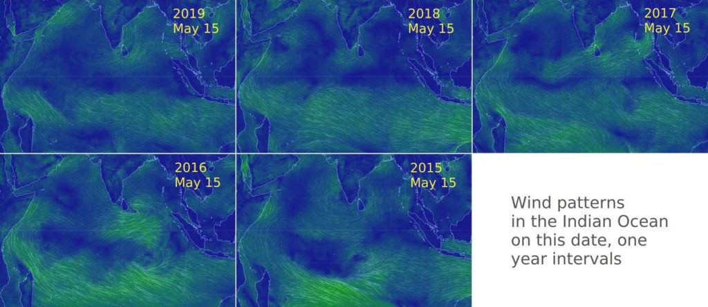
On 15 April 2019 the IMD issued its first stage forecast. Based on our own in-field observations from the west coast, from the patterns of maximum termperature bands and variations in the lower and central peninsular region, from the sea surface temperatures in the Arabian Sea particular its southerly reaches and ditto for the Bay of Bengal, and from the wind patterns that can be experienced at various places in the peninsula and on the west coast, we find the IMD first stage forecast to be reliable.

It is the chronically ignorant media – which over the last few years has displayed a tendency to prefer some so-called private sector weather forecasters instead of what the Ministry of Earth Sciences provides – found irresponsibly claiming that the monsoon of 2019 will be ‘deficient’ and will also begin ‘late’. Neither of these terms is sensible in any way, and we take no satisfaction in noting that only a media that is insensible to planetary and mesoscale events like climate, will employ such insensible terms in reporting that is meant to educate and benefit the public.

IMD’s April forecast used the following five predictors: 1. the Sea Surface Temperature (SST) Gradient between North Atlantic and North Pacific (in December and January), 2. the Equatorial South Indian Ocean SST (in February), 3. the East Asia Mean Sea Level Pressure (in February and March), 4. North-west Europe Land Surface Air Temperature (in January), and 5. Equatorial Pacific Warm Water Volume (in February and March).

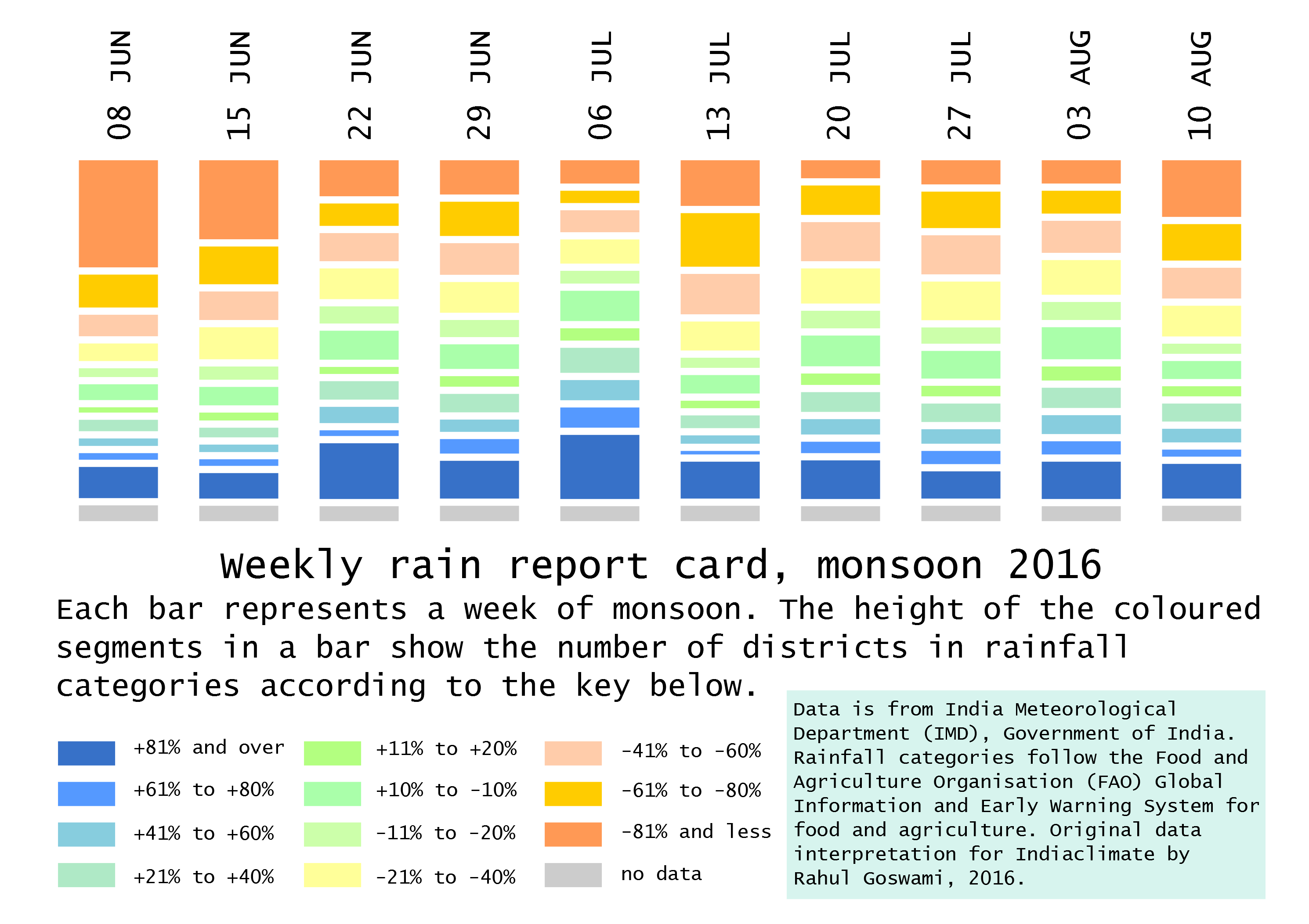
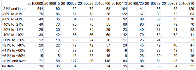
There are two forecasts the IMD makes. One is based on the Monsoon Mission CFS Model, which considers global atmospheric and oceanic initial conditions up to March 2019 and use 47 ensemble members (or kinds of data). The forecast based on the CFS model suggests that the monsoon rainfall during the 2019 monsoon season (June to September) averaged over the country as a whole is likely to be 94% ± 5% of the Long Period Average (LPA).

The second is the forecast based on the operational Statistical Ensemble Forecasting system (SEFS). This shows that quantitatively, the monsoon seasonal rainfall is likely to be 96% of the Long Period Average (LPA) with a model error of ± 5%. The SEFS comprises five category probability forecasts for the June to September rainfall over the country as a whole:

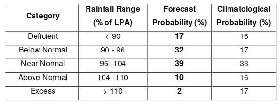
Overall therefore the IMD forecast is for the 2019 monsoon rainfall to be near normal. The IMD has already pointed out (which can be seen from the probabilities of the categories given in the table) that there is only a small chance for the monsoon rainfall to be above normal or excess. In view of the weather events and the climatological changes that we are seeing from day to day in May, ascribing a ‘lateness’ to the monsoon is absurd. Monsoon conditions already exist in and over the Indian land mass and in and over the great watery zones extending southwards from latitude 8 degrees North – and that is why we will find rain-bearing clouds crossing the south-western coastline in the first week of June 2019.

Rahul Goswami

Filed Under: Reports & Comment Tagged With: 2019, forecast, IMD, monsoon, rainfall

A mixed report for the monsoon so far

August 6, 2018 by Climate portal editor Leave a Comment

The India Meteorological Department in its ‘Long Range Forecast for the Rainfall during Second Half (August –September) of the Southwest Monsoon 2018’ has said:
(a) The rainfall during August 2018 is likely to be 96 ± 9% of LPA and expected to be higher than was predicted in June.
(b) Quantitatively, the rainfall for the country as a whole during the second half of the season (August and September) is likely to be 95% of LPA with a model error of ±8%.
(c) The tercile probability forecasts for the rainfall over the country as a whole during the 2018 second half of the monsoon season are: 47% forecast probability that it will be less than 94% of the LPA (below normal), 41% forecast probability that it will be between 94% and 106% of the LPA (normal), and only 12% forecast probability that it will be over 106% of the LPA (above normal).
The Department said that “distribution of rainfall is very good over all parts of the country except Bihar, Jharkhand and NE States. Such a scenario of favourable distribution of rainfall is expected to continue during rest of monsoon season of 2018 so as to remain favourable for agricultural operations”.

The IMD in its latest weekly ‘performance sheet’ on rainfall has calculated the cumulative rainfall up to 1 August 2018 on an ‘area weighted’ basis as being 431 mm as compared with a normal of 462 mm. But this is a measure that doesn’t tell us anything local and we have advised the IMD to abandon it. What is more useful is the enumerating of subdivisions according to cumulatie rainfall: by 1 August, there were 28 which had normal rainfall, 7 which had deficient, and one which had excess. For this period – monsoon rainfall until 1 August – this year has had the most number of subdivisions with normal rainfall in the last five years.

However it is a concern that five of the seven subdivisions which up to 1 August 2018 have had deficient rainfall are in the East and North-East India region and they are: Arunachal Pradesh (-36%), Assam and Meghalaya (-33%), NMMT which is Nagaland Manipur Mizoram Tripura (-25%), Jharkhand (-24%) and Bihar (-22%). The other two subdivisions with deficits are Rayalaseema (-41%) and Lakshadweep (-43%).

In states, Uttar Pradesh has the largest number of districts (26) registering deficient rainfall up to 1 August 2018, even though 25 of the state’s districts have had normal rainfall for the period and 18 have had excess or large excess. Bihar has 24 districts which have registered deficient rainfall for this period, followed by Jharkhand (15), Assam (14), and Gujarat, Tamil Nadu and Karnataka each with 13.

Filed Under: Latest, Monsoon 2018 Tagged With: 2018, distribution, IMD, India, monsoon, rainfall, subdivision

Three views of monsoon 2018

May 14, 2018 by Climate portal editor Leave a Comment

The India Meteorological Department (IMD) on 16 April had issued its first long range forecast for the 2018 South-West Monsoon season, which the IMD has historically taken to be 1 June to 30 September. The IMD had said that the “monsoon seasonal rainfall is likely to be 97% of the Long Period Average with a model error of ± 5%”. The IMD had also said that its forecast “suggests maximum probability for normal monsoon rainfall (96%-104% of the long period average) and low probability for deficient rainfall during the season”.

In early June, the IMD will issue its second long range forecast for the 2018 monsoon. Until then, we have studied three of the more reliable (in our view) international multi-model ensemble forecasts for the monsoon. What are ensemble forecasts? Each consists of several separate forecasts (some ensembles use 50) forecasts made by the same computer model – these are run on super-computers such as the High Performance Computer System of the Ministry of Earth Sciences (one is at the Indian Institute of Tropical Meteorology in Pune with 4.0 petaflops capacity and the other at the National Centre for Medium Range Weather Forecasting in Noida with 2.8 petaflops capacity).

The MME forecast is based on estimated precipitation anomalies relative to the period 1993-2016, based on initial conditions calculated at the beginning of May 2018. Four blocks of three months each.

The separate forecasts that make up one ensemble are all activated from the same starting time. The starting conditions for each differ from each other to account as far as possible for the staggering number of climatological, atmospheric, terrestrial and oceanographic variables that affect and influence our monsoon. The differences between these ensemble members tend to grow as the forecast travels two, three, four and more months ahead of the present.

We have considered the ensemble forecasts for the 2018 monsoon of the Multi-Model Ensemble (MME) of the USA National Centers for Environmental Prediction, the NOAA Climate Prediction Center and the European Centre for Medium-Range Weather Forecast (ECMWF). In this order, we find that the MME is optimistic, the NOAA CPC is largely neutral and the ECMWF forecast is somewhat pessimistic. The forecasting periods are in blocks of three months.

Here are the details:

(1) The MME forecast, precipitation anomalies relative to the period 1993-2016, based on initial conditions calculated at the beginning of May 2018.
June July August (JJA) – west coast and Konkan, coastal Andhra Pradesh and Odisha, West Bengal, part of the North-East, the entire upper, middle and lower Gangetic region (Uttarakhand, Himachal, Uttar Pradesh, Bihar, Jharkhand), Madhya Pradesh, Chhattisgarh, Maharashtra and Telengana to have up to +1 mm/day. Rest of India other than Gujarat (-0.5 mm/day) normal.
July August September (JAS) – Gujarat to have up to -1 mm/day, Rajasthan up to -0.5 mm/day, Sikkim, Brahmaputra valley and Arunachal Pradesh up to -0.5 mm/day. Himachal Pradesh and Uttarakhand up to +0.5 mm/day, Madhya Pradesh, Odisha, Chhattisgarh, Jharkhand and West Bengal up to +0.5 mm/day. Andhra Pradesh and Tamil Nadu up to -0.5 mm/day.
August September October (ASO) – Gujarat up to -0.5 mm/day. Tamil Nadu up to -1 mm/day. Kerala and adjacent Karnataka up to -0.5 mm/day. Madhya Pradesh, Chhattisgarh, Odisha, West Bengal up to +1 mm/day. Tripura, Mizoram, Manipur, Nagaland, Uttarakhand, Himachal Pradesh up to +0.5 mm/day
September October November (SON) – Tamil Nadu, Kerala and adjacent Karnata up to -1 mm/day. Maharashtra, Madhya Pradesh, Chhattisgarh, Odisha, West Bengal, Himachal Pradesh and Uttarakhand up to +0.5 mm/day.

The NOAA CPC forecast is based on estimated seasonal precipitation anomalies using initial conditions of 30 April 2018 to 9 May 2018. Three blocks of three months each.

(2) The NOAA CPC forecast, seasonal precipitation anomalies using initial conditions of 30 April 2018 to 9 May 2018.
May June July (MJJ) – for most of India a normal reading (+0.5 to -0.5 mm/day fluctuation) and for the west coastal, Konkan, Kerala, south Tamil Nadu and coastal Andhra Pradesh areas variation of up to +1.5 mm/day.
June July August (JJA) – for most of India a normal reading (+0.5 to -0.5 mm/day fluctuation).
July August September (JAS) – normal for most of India. Some areas in the central Deccan plateau, on the west coast and east coast variation of up to -1 mm/day.

The ECMWF forecast is based on estimated mean precipitation anomaly based on climate period data of 1993-2016 and initial conditions as on 1 May 2018. Four blocks of three months each.

(3) The ECMWF forecast, mean precipitation anomaly based on climate period data of 1993-2016 and initial conditions as on 1 May 2018.
June July August (JJA) – all of the southern peninsula and part of the Deccan region (Kerala, Tamil Nadu, Karnataka, Andhra Pradesh, part of Telengana up to -100 mm for the period. West Bengal, Bihar, Jharkhand, Uttar Pradesh up to +100 mm for the period.
July August September (JAS) – all of the southern peninsula and the Deccan region – Kerala, Tamil Nadu, Karnataka, Andhra Pradesh, part of Telengana and Maharashtra up to -100 mm for the period.
August September October (ASO) – Maharashtra, Telegana, Andhra Pradesh and Karnataka up to -100 mm for the period.
September October November (SON) – Central and western India, eastern states and entire Gangetic region up to -50 mm for the period.

Rahul Goswami

Filed Under: Latest, Monsoon 2018 Tagged With: 2018, earth sciences, forecast, IMD, India, meteorology, monsoon

The ‘Hindu’, ignorant about weather and climate, but runs down IMD

September 2, 2016 by Climate portal editor Leave a Comment

ICP_IMD_Hindu_comment_20160901

We find objectionable the report by ‘The Hindu’ daily newspaper accusing the India Meteorological Department of scientific shortcoming (‘IMD gets its August forecast wrong’, 1 September 2016). The report claims that the IMD in June 2016 had forecast that rains for August would be more than usual but that the recorded rain was less than usual.

This is nothing but cheap sensationalising by the newspaper of a non-issue. In so doing the ‘Hindu’, which is considered one of Bharat’s national newspapers, has attempted to tarnish the work of not only the India Meteorological Department, but also the work of the earth observation technical community which serve us in the several institutions and agencies of the Ministry of Earth Sciences.

There is no mainstream news media in the country – no daily newspapers, no magazine or periodical, no television channel, no internet website – which possesses the competence to assess the scientific quality and correctness of output of the government earth science agencies, and whose output is delivered to the public every day, several times a day. ‘The Hindu’ certainly does not and with this report exposes its ignorance about meteorology and climate science and observation.

Concerning the newspaper’s claim, rainfall for the period 1 June to 31 August in the 36 meteorological sub-divisions of Bharat, as an area-weighted average, is -3% of the long period average and is therefore well within the boundaries set by both the first stage and second stage forecasts provided by the IMD. Of the 36 sub-divisions, for this period 24 sub-divisions have recorded normal rainfall, four have excess and eight (including the two island sub-divisions) have deficient rainfall. In what way is this an erring forecast?

The news report in the ‘Hindu’ states that the forecasting error it has found “suggests that the agency’s weather models are still not robust enough to capture changes in global climate that could affect” our monsoon. This is nonsense.

The earth observation agencies of the MoES – of which the IMD is a part – for the June to September monsoon forecast employs a group of six parameters that inform the forecast (together called an ensemble forecasting system). These are: north-east Pacific to north-west Atlantic sea surface temperature anomaly gradient, south-east equatorial Indian Ocean sea surface temperature, East Asia mean sea level pressure, central Pacific (El Nino region 3.4), sea surface temperature and tendency, north Atlantic mean sea level pressure and north-central Pacific 850mb wind gradient. In what way does this not look at global climate?

Moreover, the IMD and the agencies of the MoES (notably the Indian Institute of Tropical Meteorology) work closely regionally and internationally on climate science, weather prediction and monitoring. Not only is the IMD implementing for the World Meteorological Organisation (WMO) a Regional Climate Centre for South Asia, the monsoon prediction and monitoring system relies on collaboration with: the National Centers for Environmental Prediction (NCEP) of USA, the European Centre for Medium-Range Weather Forecasts (ECMWF), the Japan Meteorological Agency (JMA), the Met Office Hadley Centre for Climate Science and Services of UK, and with the national meteorological agencies of Bangladesh, Bhutan, the Maldives, Myanmar, Nepal, Pakistan, and Sri Lanka.

And furthermore, it is because the Earth System Science Organisation agencies and institutes revise, review and upgrade forecasting models, computing wherewithal and methods continuously that we have in 2016 an experimental forecast (based on the Monsoon Mission coupled dynamical model).

‘The Hindu’ newspaper has presented its own uninformed reading of differences in forecast averages to make an absurd claim against the IMD, neglecting entirely to mention the extremely valuable service provided, at the district and even at the block level, to Bharat’s kisans via daily sms on weather which will affect crops; neglecting the several excellent initiatives launched by the Department since 2015 on localising forecasts for towns and cities (in close coordination with the National Remote Sensing Centre of the Indian Space Research organisation, the Meteorological and Oceanographic Satellite Data Archival Centre of ISRO’s Space Applications Centre, and the Indian National Centre for Ocean Information Services.

Filed Under: Blogs Tagged With: 2016, Bharat, forecast, IMD, India, monsoon, weather

Monsoon weekly report card 2016

August 18, 2016 by Climate portal editor Leave a Comment

ICP_district_rainweeks_20160818

Employing the modified rainfall measurement categories, we have prepared a ‘report card’ for ten weeks of rainfall beginning with the week 02-08 June and continuing until the most recent which is the week of 04-10 August. This ‘report card’ is based on the recorded rainfall for each district and how much it varies from the normal for that particular week. This variation is portrayed by our ‘report card’ through the modified categories, which are designed to show more finely not merely deficient or excess rainfall, as the current categories do, but the degree of deficiencies or excesses for that district, for that week.

ICP_RG_2016_district_10rainweeks_20160818

Our indicator of eleven grades (compared with the four of the India Meteorological Department, IMD) uses the same weekly district data to provide greater detail about rainfall adequacy or lack. Using this method we can immediately see from the chart:

1. From the week ending 22 June there have been a large number of districts – between 20% and 40% of all districts for which data is available – included in the four categories that describe rainfall of +20% above the normal.

2. That notwithstanding the overall seasonal prediction of monsoon 2016 having thus far been proved correct, there are almost every week a sizeable number of districts falling in the three categories for deficient rainfall.

3. That for the ten weeks in our report card the number of districts in the -21% to -40% below normal band is greater than the number of districts in the band for +21% to +40%.

ICP_district_rainweeks_table_20160818

In the chart, each bar corresponds to a week of district rainfall readings, and that week of readings is split into eleven grades (plus one for no data). In this way, the tendency for administrations, citizens, the media and all those who must manage natural resources (particularly our farmers), to think in terms of an overall ‘deficit’ or an overall ‘surplus’ is halted.

We find that our modified rainfall categories are more informative at the district level – and therefore cumulatively at the state and meteorological sub-division levels too  – and can readily be adopted by administrations and planners.

In today’s concerns that have to do with the impacts of climate change, with the increasing variability of the monsoon season, and especially with the production of food crops, the IMD’s stock measurement – ‘normal’ is rainfall up to +19% above a given period’s average and also down to -19% from that same average, ‘excess’ is +20% rain and more, ‘deficient’ is -20% to -59% and ‘scanty’ is -60% to -99% – is no longer viable.

Filed Under: Latest, Monsoon 2016 Tagged With: 2016, district, IMD, India, monsoon

Prepare for May heat

May 4, 2016 by Climate portal editor Leave a Comment

ICP_May_heat_20160504
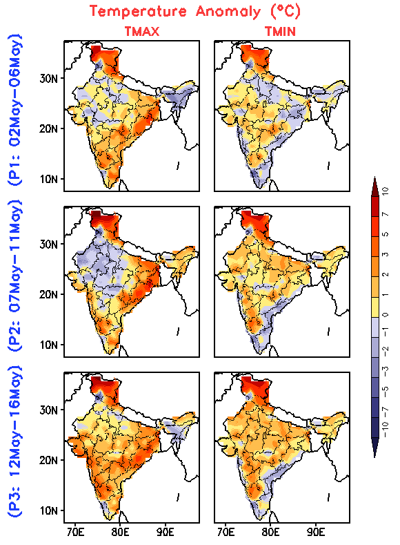
The heat outlook for the first half of May, which was released by the India Meteorological Department (IMD) on 02 May, calls for immediate attention and preparation on all fronts.

The forecast is for three periods of five days each (called pentads) with expected temperature anomalies given for maximum and minimum temperatures. The big picture is that over some parts of the country maximum temperatures will remain 3-4 C above normal for all the three pentads.

Minimum temperatures that are 1-5 degrees higher than normal will increase in terms of the geographical range as the days progress through the first, second and third pentad: 02 to 06 May, 07 to 11 May and 12 to 16 May.

There are several particular alerts arising from the IMD heat wave outlook:

The heat outlook for the first half of May, released by the India Meteorological Department (IMD), for the three five-day periods of 02 to 06 May, 07 to 11 May and 12 to 16 May.

The heat outlook for the first half of May, released by the India Meteorological Department (IMD), for the three five-day periods of 02 to 06 May, 07 to 11 May and 12 to 16 May.

1. Odisha, Gangetic West Bengal and south Chhattisgarh, which have seen some record-breaking high temperatures in April, will continue to see above normal maximum temperatures.

2. South Interior Karnataka, coastal Maharashtra and Goa (the Konkan), and Saurashtra will experience a gradual rise in maximum temperatures from the first to third pentad.

3. Maximum and minimum temperatures both, in Jammu and Kashmir, Himachal Pradesh and Uttarakhand will remain around 5 C above normal for the duration of the forecast.

4. The 12 to 16 May period (third pentad) will see higher than normal maximum temperatures (2 to 5 C) over almost the entire country, and higher than normal minimum temperatures over most of the country.

Other observations are:

5. The North-East will experience minimum temperatures about a degree higher than normal during 07 to 16 May.

6. For the second pentad, that is 07 to 11 May, maximum temperatures in north-west India (Punjab, Haryana, western Uttar Pradesh, Rajasthan, western Madhya Pradesh, Delhi) will drop by 2 to 3 C.

7. Coastal Andhra Pradesh, Rayalaseem and Tamil Nadu will experience lower minimum temperatures by 1 to 2 C during 07 to 16 May.

Please observe basic precautions during this period in particular: eat smaller meals more often; drink water even when not thirsty; avoid tea, coffee and alcohol; plan your activities to avoid being outdoors during 11am to 4pm; do not leave children in cars by themselves; keep a watch on the elderly especially those who are infirm or invalid; wear non-synthetic non-polyester light-coloured and loose fitting clothes; if working outdoors rest frequently; provide drinking water and shade to animals and pets.

Filed Under: Current Tagged With: Bharat, climate, drought, forecast, heat, heat wave, IMD, India, India Meteorological Department, temperature, water

A tribute to the weathermen of Bharat

April 12, 2016 by Climate portal editor 9 Comments

ICP_IMD_tribute_pic_20160412

When the weather causes anxiety, in the districts and towns, harassed administrators and the impatient public turn quickly to the weatherman. Whether for advice about a possible heat wave, about thunderstorms or hail storms, about extended dry spells, about the possibility of rainfall during a crop sowing period one week distant, it is the local weatherman who has the knowledge and provides the answers.

That weatherman – and weatherwoman, for the service has a number of women scientists – is from the India Meteorological Department, the weather watchers for Bharat.

Theirs is often a thankless task, of poring over the output from instruments and computations, ensuring that the essential information about weather conditions six, 12 or 24 hours hence is transmitted to all those to whom it matters.

Our weathermen scan the skies with their instruments so that they can issue, to airports and airfields all over Bharat, the ‘meteorological aerodrome report’ (or METARs) on which all our commercial flights depend. Our weathermen scan the seas with their instruments to issue the sea weather reports and fleet forecasts for marine traffic in the Arabian Sea, the Bay of Bengal, the Andaman Sea and the nearer Indian Ocean.

India Climate portal thanks readers for the appreciative responses to this tribute, and for the comments (below) which we urge the Ministry of Earth Sciences to consider.

Our weathermen scan the atmosphere with the aid of the orbital eyes of our satellites so that, for every single district, an agricultural meteorology forecast is issued every day and for every crop season. Our weathermen scan the routes of the Indian Railway system, the largest and most heavily utilised in the world, for threatening weather conditions that would affect the running of trains. They do this every single day, round the clock.

Today the India Meteorological Department has issued its first forecast for the 2016 monsoon, the Indian summer monsoon, whose patterns have been so well known for all our recorded history. It is a forecast that has been impatiently awaited this year, because of the shortages of water in our river basins, because of the likelihood – as ever – of heat waves, and because we have been so very worried about whether we will get the rains that eluded Bharat in 2015 and 2014.

The short answer is: yes we will. The details of the percentages, the probabilities, the averages, the likely ranges and other ponderables are all over the news. We’d like to compliment the people behind the forecast.

We sincerely thank the women and men of the India Meteorological Department for their extraordinary efforts – every day, week, season and year – to serve us. The IMD today provides us, in the public domain, through the internet, via television, with the help of mobile phone messages, and through smartphone apps, an array of weather services. These scientists, administrators, technicians and field staff have worked as hard to make this range of services available to us as they have worked to understand our ‘mausam’ better. Theirs is a science whose complexity defies the most powerful computing systems available, and they translate what they see into language that guides us as we go about our daily routines. It calls for a breadth of skills that must be applauded.

A sense of history and philosophy guides their work. The scientists and technicians of the Department take as much inspiration from the Upanishads (which contain serious discussion about the processes of cloud formation, rain, and the seasonal cycles) and from Varahamihira’s classical work, the Brihatsamhita, as they do from the insights that they collaborate on today in what is known as earth systems science. It is a remarkable legacy that is very much alive in the offices and field stations of the IMD.

For their work, and as representatives of the widely distributed IMD network of staff, we thank:
Director General of Meteorology, Laxman Singh Rathore; Additional Director General of Meteorology (Research), Bishwajit Mukhopadhyay; Deputy Director General of Meteorology (Upper Air Instruments), Devendra Pradhan; Deputy Director General of Meteorology (Surface Instruments), Rajesh Ramdas Mali; Deputy Director General of Meteorology, Regional Meteorological Centre New Delhi, Anand Kumar Sharma; Deputy Director General of Meteorology, Regional Meteorological Centre Mumbai, K S Hosalikar; Deputy Director General of Meteorology, Regional Meteorological Centre Kolkata, Gakul Chandra Debnath; Deputy Director General of Meteorology, Regional Meteorological Centre Chennai, S Bagulayan Thampi; Deputy Director General of Meteorology, Regional Meteorological Centre Guwahati, Sanjay Oneill Shaw; Deputy Director General of Meteorology, Regional Meteorological Centre Nagpur, P K Nandankar; Head, Agromet Services K K Singh; Deputy Director General of Meteorology, Satmet, New Delhi, Ashok Kumar Sharma; Deputy Director General of Meteorology, Hydromet, New Delhi, Surinder Kaur; Deputy Director General of Meteorology, Services, New Delhi, Brahma Prakash Yadav; Deputy Director General of Meteorology, Organisation, New Delhi, S D Attri; Deputy Director General of Meteorology, EMRC, New Delhi, Sunil Kumar Peshin; and Deputy Director General of Meteorology, Numerical Weather Prediction, New Delhi, Swapan Kumar Roy Bhowmik. Thank you all for a job very well done indeed.

Rahul Goswami

Filed Under: Monsoon 2016, Reports & Comment Tagged With: Bharat, climate, IMD, India Meteorological Department, weather

Preparing for the Indian summer

April 1, 2016 by Climate portal editor Leave a Comment

ICP_insat_20160101

The India Meteorological Department (IMD) has issued its forecast for the 2016 hot weather season (April to June). The forecast shows that during the 2016 hot weather season, temperatures (mean, maximum and minimum) in all the sub-divisions are likely to be above normal. All the temperatures (maximum, minimum and mean) of most of the subdivisions from northwest India, Kerala from south India and Vidharbha from Central India are likely to be above normal by 1.0° C or more. Read the full forecast document here (pdf).

The season averaged maximum temperatures of coastal Andhra Pradesh, Odisha, Assam and Meghalaya, sub-Himalayan west Bengal and Sikkim, and NMMT – Nagaland, Manipur, Mizoram and Tripura – are likely to be warmer by 0.5° C and that of the remaining subdivisions are likely to warmer than normal by 0.5° to 1° C. The season averaged minimum temperatures of sub-Himalayan west Bengal and Sikkim, and NMMT are likely to be warmer than normal by <0.5° C and that of the remaining subdivisions are likely to warmer than normal by 0.5° to 1° C.

There is also a high probability (76%) of maximum temperatures in the core heat wave zone during the 2016 hot weather season to be above normal. The core heat wave zone covers the states of Punjab, Himachal Pradesh, Uttarakhand, the National Capital Territory and Delhi, Haryana, Rajasthan, Uttar Pradesh, Gujarat, Madhya Pradesh, Chhattisgarh, Bihar, Jharkhand, West Bengal, Odisha and Telengana and the meteorological sub-divisions of Marathwada, Vidharbha, Madhya Maharashtra and coastal Andhra Pradesh. This in turn suggests high probability of moderate and severe heat wave conditions in the core heat wave zone during the hot weather season.

From this season, the IMD will also provide extended range forecasts (five–day averaged forecasts for the next 15 days) of heat wave conditions over the country. This will be based on the Dynamical Extended Range Forecasting System developed by the Indian Institute of Tropical Meteorology (IITM) in Pune. The forecast will consist of the probability of occurrence of hot days, heat waves and severe heat waves for the next 15 days updated every fifth day from 1 April, 2016. The forecasts will be available on the IMD website.

Filed Under: Latest Tagged With: Bharat, heat, heat wave, hot weather, IMD, India, India Meteorological Department, summer, temperature, पृथ्‍वी विज्ञान, भारत, मौसम

Where they waited for rain in 2015

September 18, 2015 by Climate portal editor 1 Comment

RG_ICP_20150918

With two weeks of the June to September monsoon remaining in 2015, one of the end-of-season conclusions that the India Meteorological Department (IMD) has spoken of is that four out of ten districts in the country has had less rainfall than normal.

This overview is by itself alarming, but does not aid state governments and especially line ministries plan for coming months, particularly for agriculture and cultivation needs, water use, the mobilisation of resources for contingency measures, and to review the short- and medium-term objectives of development programmes.

RG_ICP_100districts_table_20150918The detailed tabulation provided here is meant to provide guidance of where this may be done immediately – in the next two to four weeks – and how this can be done in future.

The table lists 100 districts each of which have readings 15 weeks of rainfall variation – the numbers are not rainfall in millimetres (mm) but the variation in per cent from the long-term normal for that district for that week. The colour codes for each district’s week cell are the same as those used for the new 11-grade rainfall categorisation.

The districts are chosen on the basis of the size of their rural populations (calculated for 2015). Thus Purba Champaran in Bihar, Bhiwani in Haryana, Rewa in Madhya Pradesh and Viluppuram in Tamil Nadu are the districts in those states with the largest rural populations.

In this way, the effect of rainfall variability, from Week 1 (which ended on 3 June) to Week 15 (which ended on 9 September), in the districts with the largest rural populations can be analysed. Because a large rural population is also a large agricultural population, the overall seasonal impact on that district’s agricultural output can also be inferred.

The distribution of the districts is: six from Uttar Pradesh; five each from Andhra Pradesh, Bihar, Chhattisgarh, Gujarat, Haryana, Jharkhand, Karnataka, Maharashtra, Madhya Pradesh, Odisha, Punjab, Rajasthan, Tamil Nadu and West Bengal; four each from Assam, Jammu and Kashmir, and Kerala; three from Uttarakhand; two from Himachal Pradesh; one each from Arunachal Pradesh, Manipur, Meghalaya, Mizoram, Nagaland, Sikkim and Tripura.

Using the new 11-grade rainfall categorisation, a normal rainweek is one in which the rainfall is between +10% more and -10% less for that week. The overview for this group of 100 districts, only 11 have had five or more normal weeks of rain out of 15 weeks. In alarming contrast, there are 77 districts which have had three or fewer normal weeks of rain – that is, more than three-fourths of these most populous districts. Half the number (51 districts) have had two, one or no normal weeks of rain. And 22 of these districts have had only one or no normal weeks of rain.

From this group of 100 most populous (rural population) districts Gorakhpur in Uttar Pradesh and Nagaon in Assam have had the most deficit rainweeks, tallying 13, out of the 15 tabulated so far. There are ten districts which have had 12 deficit rainweeks out of 15 and they are (in decreasing order of rural population): Muzaffarpur (Bihar), Pune and Jalgaon (Maharashtra), Surguja (Chhattisgarh), Panch Mahals and Vadodara (Gujarat), Firozpur (Punjab), Thiruvananthapuram (Kerala), Hoshiarpur (Punjab) and Mewat (Haryana).

– Rahul Goswami

Filed Under: Monsoon 2015, Reports & Comment Tagged With: agriculture, district, IMD, India, monsoon, population, rain, rural, urban, water

A monsoon in more than two halves

August 4, 2015 by Climate portal editor Leave a Comment

ICP_imd_forecast_20150804

Less rain for the remaining two months of the typical monsoon season of four months, but an overall season average that remains as it was forecast in June. This is the confusing monsoon update issued by the Earth System Science Organization (ESSO), the Ministry of Earth Sciences (MoES) and the India Meteorological Department (IMD).

There are aspects of IMD’s treatment of the monsoon season that need correction in our view. One is the long range forecast and its updates. Specific to this update, we are at the halfway stage of what is typically considered the four month monsoon (this too needs revision, as April and May rains were not the usual ‘unseasonal’ passing showers). However, any downward revision of the rainfall average for August and September ought to be an overall downward revision of the season, particularly as June-July have seen very uneven rain.

Consider the highlights of the updated monsoon forecast:

* Quantitatively, the rainfall over the country as a whole during the second half of the season (August to September) is likely to be 84% of LPA with a model error of ±8%.
* The rainfall during August is likely to be 90 ± 9% of LPA as was forecasted in June.
* The season (June to September) rainfall over the country as a whole is likely to be 88% of LPA with a model error of ±4% as was forecasted in June.

ICP_imd_points_20150804We make our criticism constructively, for a significant amount of the material India Climate Portal puts out through our website and our twitter account is taken from the public products released by IMD, ISRO and the Ministry of Earth Sciences, and we fully appreciate the quality of work and commitment of these agencies.

The national mean rainfall (“country as a whole”, as the IMD forecasts call it) must be abandoned as it does not represent the meteorological diversity of a very large country. Each of the 36 met sub-divisions is affected in different ways by the El Nino Southern Oscillation, the Indian Ocean dipole, the Madden-Julian Oscillation and other hemispheric phenomena.

There is no need for this simplification, which in fact achieves the opposite of timely accuracy.
The media in particular (television and radio, print, online) look for an overall message and, without guidance from authorities, picks up ‘top line’ messages that are of little or no use at the district and taluka level, and also for towns and cities. The question for IMD is rather: how will variability in monsoon together with the strengthening El Nino affect local outlooks for August to October. That is why we advocate monthly outlooks for the 36 met sub-divisions, to begin in May and to run until October (that is, half the year and not a third of the year), primarily to prepare local administrations for all possible scenarios.

There is no reason why this cannot be the approach. The Ministry of Earth Sciences coordinates the observation network (satellites included, and our agencies ISRO and NRSC are heavily involved), the IMD uses these data together with a very extensive network of weather stations all over India. The output is excellent quality and in the public domain. Because the meteorological services in India have historically been designed to aid and guide agriculture and cultivation, the agri-met bulletins, alerts and products are copious. Hence IMD/MoES listens to the needs of the agricultural departments and, more recently, disaster management agencies. Unfortunately, the interface with public is still minimal, which this central government can also easily remedy.

Filed Under: Latest, Monsoon 2015 Tagged With: 2015, climate, earth sciences, El Nino, forecast, IMD, India, ISRO, monsoon

  • 1
  • 2
  • 3
  • Next Page »

Indiaclimate twitter

Tweets by @Indiaclimate

Notable

Between contemplation and climate

Whether or not the USA, Europe, the Western world, the industrialised Eastern world (China, Japan, South Korea, Taiwan), adhere to or not their paltry promises about being more responsible concerning the factors that lead to climate change, is of very little concern to us. We have never set any store by international agreements on climate […]

The ‘Hindu’, ignorant about weather and climate, but runs down IMD

We find objectionable the report by ‘The Hindu’ daily newspaper accusing the India Meteorological Department of scientific shortcoming (‘IMD gets its August forecast wrong’, 1 September 2016). The report claims that the IMD in June 2016 had forecast that rains for August would be more than usual but that the recorded rain was less than […]

dialogue

  • Misreading monsoon | Resources Research on Misreading monsoon
  • Satish on A tribute to the weathermen of Bharat
  • Climate portal editor on A tribute to the weathermen of Bharat
  • Climate portal editor on A tribute to the weathermen of Bharat
  • Climate portal editor on A tribute to the weathermen of Bharat

Categories

Copyright © 2025 indiaclimateportal.org.