The India Climate Observatory

Commentary, action and research on climate and development in India

  • Home
  • About
  • Monsoon 2018
  • Current
  • Bulletin
  • Contact
  • Announcements

The Indiaclimate Rainfall Index 2019

July 15, 2019 by Climate portal editor Leave a Comment

We have compiled the Indiaclimate District Rainfall Adequacy Index for the monsoon season of 2019. As with our previous editions of the index series, this one for the 2019 monsoon applies our innovation to the communicating of the weekly changes in rainfall adequacy as recorded by the India Meteorological Department (IMD).

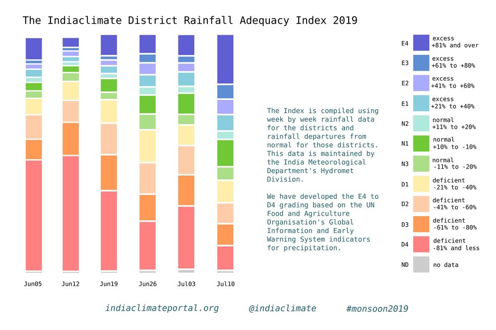
The graph (or visualisation as any such illustration is called nowadays, a word that makes the simple graph or chart sound sophisticated, but which usually complicates matters instead of simplifying them) is easy enough to read and interpret. What you have is several vertical bars, each corresponding to dates a week apart. The bars are made up of coloured segments – there are 11 coloured segments and one grey segment, a total of 12 segments.

Each of the 11 colours represents the number of districts whose rainfall readings for a week (the week till the date given) fall within the parameters given in the accompanying legend. There are three groups of colours: three segments in the ‘normal’ ranges, four segments in the ‘excess’ ranges and four segments in the ‘deficient’ ranges. Grey represents no data for that week.

The gradation of the segments is based on, but is not a copy of, the grades used by the UN Food and Agriculture Organisation’s (FAO) Global Information and Early Warning System (GIEWS) indicators for precipitation. The numbers that we use are from the IMD’s Hydrometeorology Division, which releases its ‘rainfall departures’ table every week. We take these numbers, reprocess them and redistribute them across the 11 grades.
It is a much more readily readable graph and provides for quick interpretation. The grades are finer than the six used by the IMD: normal (+19% to -195), excess (+20% to +59%), large excess (+60% or more), deficient (-20% to -59%), large deficient (-60% to -99%), no rain (-100%).

Our index, in which most segments are of 20 percentage points, is designed for local administrations – in districts but also municipal bodies – to take their cues from weekly signals and prepare if need be for a drought-like situation with water shortages or a flood-like situation with inundation.

How does it work in practice? Let’s look at the district of Guna, in Madhya Pradesh, in the meteorological sub-division of Western MP. The first two monsoon weeks, ending 5 June and 12 June, Guna received no rain (that is, -100% of the rainfall it normally receives in those weeks) and that corresponds to the D4 indicator. The next week, ending 19 June, it received -29% which is D1, the fourth week (26 June) it slipped back to -72% which is D3, the following week (3 July) it improved to -32% which is again D1 and in the sixth week (10 July) Guna received +34% which took it into the E1 grade.

Normally, a district that has received no rainfall or neglible rainfall for six weeks becomes a candidate for a drought-like condition – water sources after the long and hot summer have dried up and crops become parched. If such conditions continue for another two weeks, the state administration must roll out relief measures.

In our example, for the five weeks until the week of 3 July Guna had two D4s, one D3 and two D1s before coming out of the D grades. Our index gives the district (or town) administration the means with which to set their own triggers for action. If the water sources in the district were still at 10%-15% of their water holding capacities by the week of 3 July, then they could consult the medium term forecasts to gauge whether likely rainfall will be enough to hold off relief action. If not, and stored water slipped under 10% with uncertain forecasts, they could ask for relief and issue appropriate crop advisories.
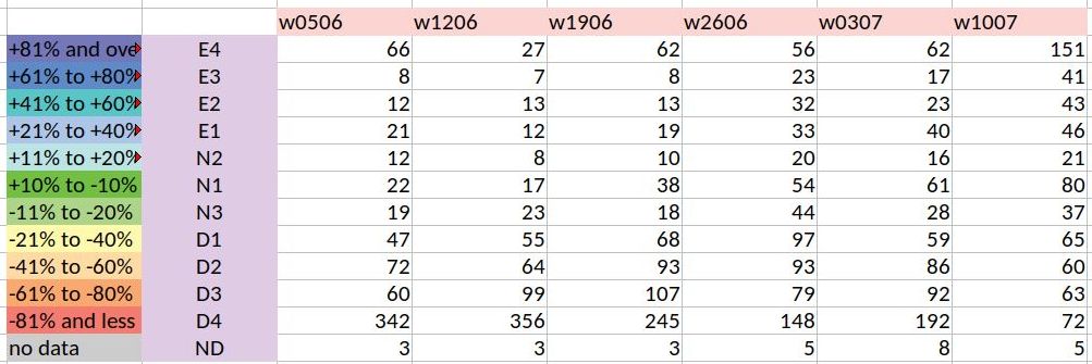
Our index graph – the stacked and segmented bar chart I am sorely tempted to call a ‘signature’ – is a representation of the numbers in the rainweeks table we compile. This table has 684 components which are the districts, each of which has a rainfall reading for the week given (in millimetres) and a rainfall departure (in %). The graph is a set of stacked bars for each week, with each segment sized according to the number of districts in the grade that the segment corresponds to.

What does the index graph for six weeks tell us? The first two monsoon weeks were alarming, with 342 and then 356 districts in the D4 grade. The situation has slowly improved thereafter, with the latest week, that of 10 July, being the best so far – it has 80 districts in the N1 grade. That last week also has for the first time in monsoon 2019 more E grade districts than D grade districts. What needs to be looked out for is districts that have been in the D4 and D3 grades for four and more weeks and whose recovery is patchy. That monitoring becomes much easier with the Indiaclimate District Rainfall Adequacy Index.

Rahul Goswami
Filed Under: Latest, Monsoon 2019 Tagged With: 2019, agriculture, district, drought, flood, India, monsoon, rainfall, water

Vidarbha’s monsoon secret comes out in our innovative new rainfall index

August 18, 2017 by Climate portal editor Leave a Comment

Monsoon rains in Vidarbha better than the rains in Konkan Maharashtra? How can this be possible? Especially when the average rainfall for the seven districts of Konkan Maharashtra, over 1 June to 9 August, is 1,812 mm and the average rainfall for the 11 districts of Vidarbha Maharashtra is 427 mm over the same period?

The measure that we are piloting is not based on the cumulative totals, for each district during each week of monsoon 2017, but for how adequate the rainfall has been over each week. What does that mean? Maharashtra’s Konkan region receives over four times the amount of rainfall that Vidarbha does. This does not mean that Vidarbha is more ‘rain poor’ than Konkan Maharashtra. The two meteorological regions are different just as their agro-ecologies, soils, water retention structures and flora are different.

Because of this difference, it is more useful to us to judge how adequate rainfall has been over any given period of measurement. We have taken a week because that is what we have data for, as provided by the Department of Hydrometeorology or the Department of Agricultural Meteorology of the India Meteorological Department, Ministry of Earth Sciences.

If you examine the cumulative totals – this means the running totals which from one week to the next carry over extras or deficits – the picture is as follows. One district only (Mumbai City) of the seven in Konkan Maharashtra is deficit (with -22%), all the rest being ‘normal’ in the range of -19% to +22%. The cumulative measurement picture for Vidarbha is this: only four out of the 11 districts (Buldana, Gadchiroli, Nagpur and Wardha) are ‘normal’ and in the range of -15% to -19%. The remaining seven are ‘deficit’ in the range of -23% to -36% (Amravati and Yavatmal being the lowest).

The weakness of the cumulative measure is that it ‘carries forward’ deficits and surpluses. A deficit in weeks 3 and 4 can be ‘made up’ for by better rains in week 5 and 6. But when rain in weeks 3 and 4 are important for a particular phase of a crop’s growth, the surplus that follows is of little use.

That’s where this pilot measure, what I have called the ‘rainfall adequacy index’, comes in. It indexes normalcy and variation from normalcy, plus or minus, and so records how adequate every week has been for the district. Using this method, we find that among Maharashtra’s meteorological regions, it is Vidarbha that has done best over 1 June to 9 August, followed by Konkan Maharashtra, then by Madhya Maharashtra and with Marathwada last.

The footnote is that the three districts with the best ‘rainfall adequacy index’ over this period are, in order, Sindhudurg, Nagpur and Wardha. The three districts with the worst index are Osmanabad, Nashik and both Thane and Palghar.

– Rahul Goswami

Filed Under: Latest, Monsoon 2017 Tagged With: 2017, agriculture, district, ecology, hydrometeorology, India, Konkan, Madhya Maharashtra, Maharashtra, Marathwada, monsoon, Mumbai, rainfall, Vidarbha, water

Big water storage wheel

April 29, 2017 by Climate portal editor Leave a Comment

The Central Water Commission, Ministry of Water Resources, Government of India, monitors every day the quantity of water stored (and used from) each of the 91 major reservoirs of the country. It issues a bulletin every week that gives the weekly storage position of these reservoirs – the volume of water, the level of water in the reservoir and the change from the last week, the change from the same date last year and from the average on this date of the last ten years.

The water storage capacity of these 91 reservoirs taken together is 157.799 billion cubic metres (bcm) which is estimated to be about 62% of the total water storage capacity (in other smaller dams and storage structures all over the country) that has been built and is being used, and which is approximately 253.38 bcm. Out of these 91 reservoirs, hydro-electric power stations (with a capacity of 60 megawatts and more) are attached to 37 reservoirs.

In this illustration by Indiaclimate, for the first time the total storage capacity of the 91 major reservoirs has been visually mapped to show reservoir, state and zone capacities relative to each other and the total.

These are the reservoirs with state, reservoir name and full reservoir level in billion cubic metres (bcm). For a good quality file that you can print, write to us.

South zone reservoirs (AP for Andhra Pradesh, TG for Telengana, APTG for Andhra Pradesh and Telegana together, KAR for Karnataka, TN for Tamil Nadu, KER for Kerala): AP, Somasila (1.994); TG, Sriramsagar (2.3); TG, Lower Manair (0.621); APTG, Srisailam (8.288); APTG, Nagarjuna Sagar (6.841); KAR, Krishnaraja Sagra  (1.163); KAR, Tungabhadra (3.276); KAR, Ghataprabha (1.391); KAR, Bhadra (1.785); KAR, Linganamakki (4.294); KAR, Narayanpur (0.863); KAR, Malaprabha (Renuka) (0.972); KAR, Kabini (0.444); KAR, Hemavathy (0.927); KAR, Harangi (0.22); KAR, Supa (4.12); KAR, Vanivilas Sagar (0.802); KAR, Almatti (3.105); KAR, Gerusoppa (0.13); KER, Kallada (Parappar) (0.507); KER, Idamalayar (1.018); KER, Idukki (1.46); KER, Kakki (0.447); KER, Periyar (0.173); KER, Malapmuzha (0.224); TN, Lower Bhawani (0.792); TN, Mettur (Stanley) (2.647); TN, Vaigai (0.172); TN, Parambikulam (0.38); TN, Aliyar (0.095); TN, Sholayar (0.143). Total for 31 reservoirs 51.59 bcm

West zone reservoirs (GUJ for Gujarat, MAH for Maharashtra): GUJ, Ukai (6.615); GUJ, Sabarmati (Dharoi) (0.735); GUJ, Kadana (1.472); GUJ, Shetrunji (0.3); GUJ, Bhadar (0.188); GUJ, Damanaganga (0.502); GUJ, Dantiwada (0.399); GUJ, Panam (0.697); GUJ, Sardar Sarovar (1.566); GUJ, Karjan (0.523); MAH, Jayakwadi (Paithon) (2.171); MAH, Koyana (2.652); MAH, Bhima (Ujjani) (1.517); MAH, Isapur (0.965); MAH, Mula (0.609); MAH, Yeldari (0.809); MAH, Girna (0.524); MAH, Khadakvasla (0.056); MAH, Upper Vaitarna (0.331); MAH, Upper Tapi (0.255); MAH, Pench (Totaladoh) (1.091); MAH, Upper Wardha (0.564); MAH, Bhatsa (0.942); MAH, Dhom (0.331); MAH, Dudhganga (0.664); MAH, Manikdoh (Kukadi) (0.288); MAH, Bhandardara (0.304). Total for 27 reservoirs 27.07 bcm

East zone reservoirs (JHR for Jharkhand, ODI for Odisha, WB for West Bengal, TRI for Tripura): JHR, Tenughat (0.821); JHR, Maithon (0.471); JHR, Panchet Hill (0.184); JHR, Konar (0.176); JHR, Tilaiya (0.142); ODI, Hirakud (5.378); ODI, Balimela (2.676); ODI, Salanadi (0.558); ODI, Rengali (3.432); ODI, Machkund (Jalput) (0.893); ODI, Upper Kolab (0.935); ODI, Upper Indravati (1.456); WB, Mayurakshi (0.48); WB, Kangsabati (0.914); TRI, Gumti (0.312). Total for 15 reservoirs 18.83 bcm

Central zone reservoirs (UP for Uttar Pradesh, UTT for Uttarakhand, MP for Madhya Pradesh, CHT for Chhattisgarh): UP, Matatila (0.707); UP, Rihand (5.649); UTT, Ramganga (2.196); UTT, Tehri (2.615); MP, Gandhi Sagar (6.827); MP, Tawa (1.944); MP, Bargi (3.18); MP, Bansagar (5.166); MP, Indira Sagar (9.745); MP, Barna (0.456); CHT, Minimata Bangoi (3.046); CHT, Mahanadi (0.767). Total for 12 reservoirs 42.30 bcm

North zone reservoirs (HP for Himachal Pradesh, PUN for Punjab, RAJ for Rajasthan): HP, Gobind Sagar (Bhakra) (6.229); HP, Pong Dam (6.157); PUN, Thein  (2.344); RAJ, Mahi Bajaj Sagar (1.711); RAJ, Jhakam (0.132); RAJ, Rana Pratap Sagar (1.436). Total for 6 reservoirs 18.01 bcm

Filed Under: Current Tagged With: agriculture, Bharat, dam, drinking water, hydel, hydro, India, irrigation, reservoir, water, water pump, water resources, water storage

From space, a district and its water

October 9, 2015 by Climate portal editor 3 Comments

RG_ICP_water_district_map_201510

In this panel of maps the relationship between the district of Parbhani (in the Marathwada region of Maharashtra) and water is graphically depicted over time. The blue squares are water bodies, as seen by a satellite equipped to do so. The intensity of the blue colour denotes how much water is standing in that coloured square by volume – the deeper the blue, the more the water.

Water bodies consist of all surface water bodies and these are: reservoirs, irrigation tanks, lakes, ponds, and rivers or streams. There will be variation in the spatial dimensions of these water bodies depending on how much rainfall the district has recorded, and how the collected water has been used during the season and year. In addition to these surface water bodies, there are other areas representing water surface that may appear, such as due to flood inundations, depressions in flood plains, standing water in rice crop areas during transplantation stages. Other than medium and large reservoirs, these water features are treated as seasonal and some may exist for only a few weeks.

RG_ICP_water_district_map_201510_section

Click for a section of the full size image. The detail can be mapped to panchayat level.

The importance of monitoring water collection and use at this scale can be illustrated through a very brief outline of Parbhani. The district has 830 inhabited villages distributed through nine tehsils that together occupy 6,214 square kilometres, eight towns, 359,784 households in which a population of 1.83 million live (1.26 rural and 0.56 million urban). This population includes 317,000 agricultural labourers and 295,000 cultivators – thus water use and rainfall is of very great importance for this district, and indeed for the many like it all over India.

This water bodies map for Parbhani district is composed of 18 panels that are identical spatially – that is, centred on the district – and display the chronological progression of water accumulation or withdrawal. Each panel is a 15-day period, and the series of mapped fortnights begins on 1 January 2015.

The panels tell us that there are periods before the typical monsoon season (1 June to 30 September) when the accumulation of water in surface water bodies has been more than those 15-day periods found during the monsoon season. See in particular the first and second fortnights of March, and the first fortnight of April.

During the monsoon months, it is only the two fortnights of June in which the accumulation of water in the surface water bodies of Parbhani district can be seen. The first half of July and the second half of August in particular have been recorded as relatively dry.

This small demonstration of the value of such information, provided at no cost and placed in the public domain, is based on the programme ‘Satellite derived Information on Water Bodies Area (WBA) and Water Bodies Fraction (WBF)’ which is provided by the National Remote Sensing Centre (NRSC), Indian Space Research Organisation (ISRO), Department of Space, Government of India.

For any of our districts, such continuous monitoring is an invaluable aid to: facilitate the study of water surface dynamics in river basins and watersheds; analyse the relationships between regional rainfall scenarios and the collection and utilisation of water in major, medium reservoirs and irrigation tanks and ponds; inventory, map and administer the use of surface water area at frequent intervals, especially during the crop calendar applicable to district and agro-ecological zones.

Filed Under: Blogs, Monsoon 2015 Tagged With: agriculture, district, ISRO, Maharashtra, monsoon, NRSC, rain, remote sensing, reservoir, river, rural, space, town, urban, village, water

Where they waited for rain in 2015

September 18, 2015 by Climate portal editor 1 Comment

RG_ICP_20150918

With two weeks of the June to September monsoon remaining in 2015, one of the end-of-season conclusions that the India Meteorological Department (IMD) has spoken of is that four out of ten districts in the country has had less rainfall than normal.

This overview is by itself alarming, but does not aid state governments and especially line ministries plan for coming months, particularly for agriculture and cultivation needs, water use, the mobilisation of resources for contingency measures, and to review the short- and medium-term objectives of development programmes.

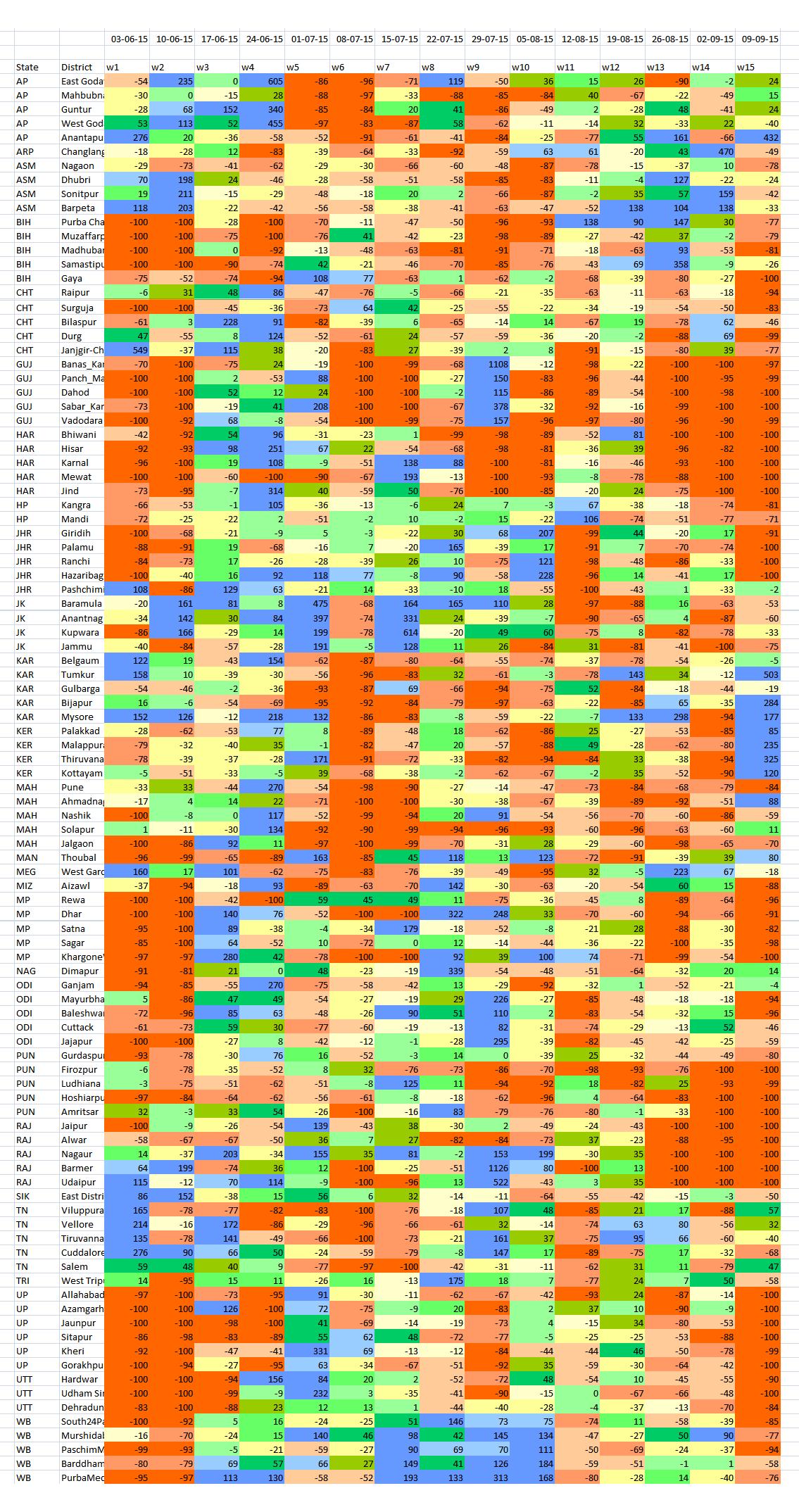
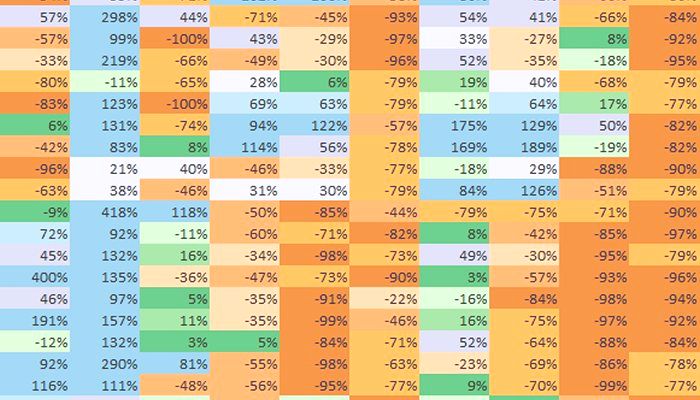
RG_ICP_100districts_table_20150918The detailed tabulation provided here is meant to provide guidance of where this may be done immediately – in the next two to four weeks – and how this can be done in future.

The table lists 100 districts each of which have readings 15 weeks of rainfall variation – the numbers are not rainfall in millimetres (mm) but the variation in per cent from the long-term normal for that district for that week. The colour codes for each district’s week cell are the same as those used for the new 11-grade rainfall categorisation.

The districts are chosen on the basis of the size of their rural populations (calculated for 2015). Thus Purba Champaran in Bihar, Bhiwani in Haryana, Rewa in Madhya Pradesh and Viluppuram in Tamil Nadu are the districts in those states with the largest rural populations.

In this way, the effect of rainfall variability, from Week 1 (which ended on 3 June) to Week 15 (which ended on 9 September), in the districts with the largest rural populations can be analysed. Because a large rural population is also a large agricultural population, the overall seasonal impact on that district’s agricultural output can also be inferred.

The distribution of the districts is: six from Uttar Pradesh; five each from Andhra Pradesh, Bihar, Chhattisgarh, Gujarat, Haryana, Jharkhand, Karnataka, Maharashtra, Madhya Pradesh, Odisha, Punjab, Rajasthan, Tamil Nadu and West Bengal; four each from Assam, Jammu and Kashmir, and Kerala; three from Uttarakhand; two from Himachal Pradesh; one each from Arunachal Pradesh, Manipur, Meghalaya, Mizoram, Nagaland, Sikkim and Tripura.

Using the new 11-grade rainfall categorisation, a normal rainweek is one in which the rainfall is between +10% more and -10% less for that week. The overview for this group of 100 districts, only 11 have had five or more normal weeks of rain out of 15 weeks. In alarming contrast, there are 77 districts which have had three or fewer normal weeks of rain – that is, more than three-fourths of these most populous districts. Half the number (51 districts) have had two, one or no normal weeks of rain. And 22 of these districts have had only one or no normal weeks of rain.

From this group of 100 most populous (rural population) districts Gorakhpur in Uttar Pradesh and Nagaon in Assam have had the most deficit rainweeks, tallying 13, out of the 15 tabulated so far. There are ten districts which have had 12 deficit rainweeks out of 15 and they are (in decreasing order of rural population): Muzaffarpur (Bihar), Pune and Jalgaon (Maharashtra), Surguja (Chhattisgarh), Panch Mahals and Vadodara (Gujarat), Firozpur (Punjab), Thiruvananthapuram (Kerala), Hoshiarpur (Punjab) and Mewat (Haryana).

– Rahul Goswami

Filed Under: Monsoon 2015, Reports & Comment Tagged With: agriculture, district, IMD, India, monsoon, population, rain, rural, urban, water

Lessons of monsoon 2015 for district India

September 16, 2015 by Climate portal editor 2 Comments

ICP_rainweek_commentary_20150916

By our conventional method of reckoning the adequacy of the 2015 monsoon, this is a year that is amongst the most deficient in rain over a period of 20 years. The monsoon season began late, compared with its usual onset, and apart from a few sustained heavy spells in a few locations, has been less than adequate and also less than normal in every one of our 36 meteorological sub-divisions.

When after eight weeks of the conventional monsoon season it became evident that a combination of factors was causing weak and erratic rainfall, that is when the central and state governments needed to place on alert the regions that were already facing rainfall deficits. At this point, when we have the evidence provided by data for 15 weeks of the monsoon season (until 9 September), every week from early August onwards that passed without such a declaration is a week of preparation and coping lost.

In this commentary, I have described the advantages of using a new methodology that grades rainfall adequacy at the level of the district, to a degree that is very much finer than the five categories of the India Meteorological Department (IMD), which are: normal, excess, deficient, scanty and no rain. The outputs from this methodology (illustrated and described here) are designed to: (1) alert national food and agriculture administrators to impending food insecurity conditions; (2) alert national water resources administrators to impending water scarcities; (3) alert line departments of state ministries and district collectorates to the build up of climatological distress at the district level so that contingency measures can be taken.

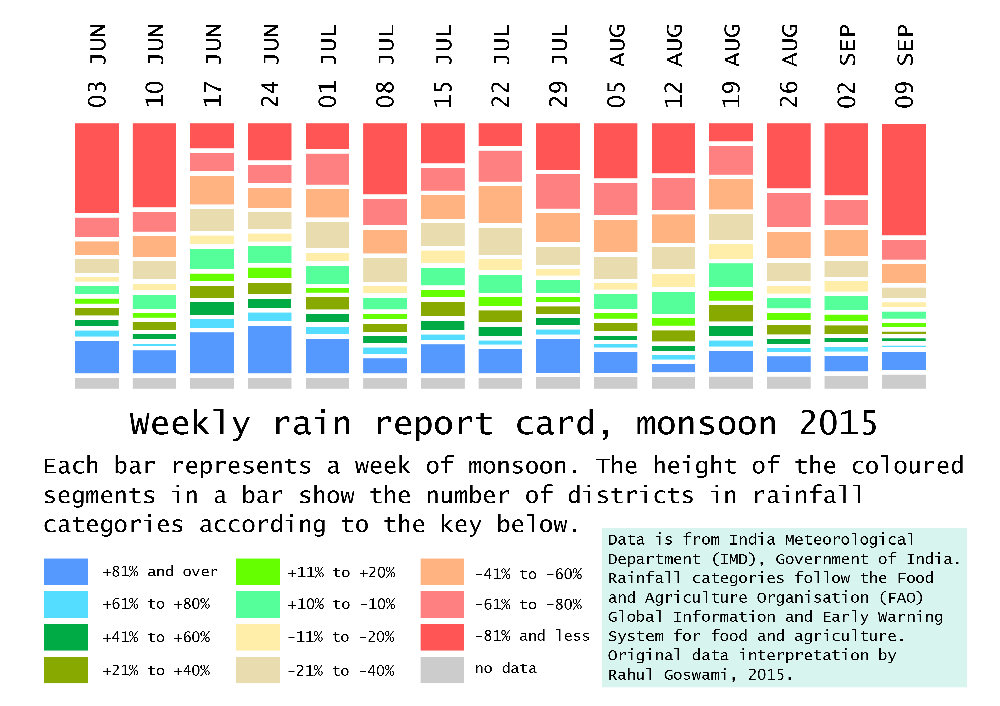
RG_2015_rainweek_graphic3Over the conventional season (1 June to 30 September) the inadequacy of rainfall in 2015 is revealed at a glance by the weekly rain report. It makes for a very alarming picture and shows that state administrations and especially district authorities should, by the sixth week which ended on 8 July, have made arrangements to prepare for below-normal rains. In the weekly rain report, each vertical bar corresponds to a week of districts categorised into eleven grades. This provides a weekly national barometer of the number of districts that are in the lower and upper (severely below and above normal rainfall) categories during a given week.

Such a weekly rainfall adequacy report is able to quickly put a stop to the recent tendency of administrations, the media and all those who must manage natural resources (particularly our farmers), to think in terms of an overall seasonal ‘deficit’ or an overall seasonal ‘surplus’. This ‘seasonal’ view must be abandoned because demands for water are not cumulative – they are made several times a day, and become more or less intense according to a cropping calendar, which in turn is influenced by the characteristics of a river basin and of a corresponding agro-ecological zone, and the rural and urban populations in a district.

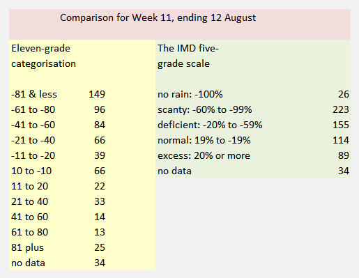
The difference between the IMD five-grade assessment and the eleven-grade categorisation of rainfall becomes immediately apparent when a comparison is made for any given week. The data source is the same – the weekly tabulation compiled by the IMD’s Hydromet Division (which from this monsoon season provides the data sheets and detailed maps on its ‘customised rainfall information system’, or CRIS, website).

RG_ICP_grade_systems_comparedWeek 11 of the monsoon season, which is the week until 12 August, provides such an example. Under the five-grade IMD scale, there were 114 districts with normal rain (from -19% to +19%). Under the 11-grade new categorisation, the middle grade is -10% to +10%, and included 66 districts. Under the five-grade IMD scale districts with below normal rainfall fall under deficient (-20% to -59%) or under scanty (-60% to -99%) and for this week the number of districts respectively were 155 and 223. Under the 11-grade new categorisation, there are four grades for below-normal rainfall that is -20%.

Thus while the ‘deficient’ grade includes 155 districts, under the 11-grade system there are 150 districts distributed between two grades – 84 and 66, but we see that a larger number of districts fall in the more severe of the two grades. The signal to be derived from this, at the state and districts administration level, is that if a district remains for two to three weeks at a grade, then contingency measures must be reviewed, readied or rolled out. This is a decision that becomes considerably easier with the 11-grade system when compared with the existing five-grade system.

In the same way, the week by week tabulation of districts under the 11-grade system reveals trends and patterns that are not visible under the existing IMD five-grade assessment. The table shows the distribution of districts by grade across weeks. In each week, the two grades that account for the largest number of districts are highlighted red. We see that for the the first five rain weeks – week ending 3 June to week ending 1 July – the +81% and above grade was one of the top two populated grades. This occurred once more for Week 7, ending 15 July. For the next eight rain weeks – ending 22 July to ending 9 September – the top two populated grades have been in the rainfall grades of -41% to -60%, -61% to -80% and -81% and less. At the country level, this starkly underlines the seriousness of the rainfall deficit.

RG_ICP_weekly_tableThe uses to which we have put available climatic observations no longer suit an India which is learning to identify the impacts of climate change. Until 2002, the monsoon season was June to September, there was an assessment in May of how well (or not) the monsoon could turn out.

The India Meteorology Department has added computational and analytical resources furiously over the last decade. The new research and observational depth is complemented by the efforts of a Ministry of Earth Sciences which has channelled the copious output from our weather satellites, under the Indian Space Research Organisation (ISRO), and which is interpreted by the National Remote Sensing Centre (NRSC), to serve meteorological needs.

The IMD, with 559 surface observatories, 100 Insat satellite-based data collection platforms, an ‘integrated agro-advisory service of India’ which has provided district-level forecasts since 2008, a High Performance Computing System commissioned in 2010 (whose servers run at Pune, Kolkata, Chennai, Mumbai, Guwahati, Nagpur, Ahmedabad, Bengaluru, Chandigarh, Bhubaneswar, Hyderabad and New Delhi) intelligently consumes an astonishing amount of numerical data every hour.

Over the last four years, more climate and weather ‘products’ (as the IMD system calls them) based on this data and their interpretations have been released via the internet into the public domain. These are reliable, timely (some observation series have even three-hour intervals), and valuable for citizen and administrator alike.

Even so, the IMD’s framing of how its most popular measures are categorised is no longer capable of describing what rain – or the absence of rain – affects our districts. These popular measures are distributed every day, weekly and monthly in the form of ‘departures from normal’ tables, charts and maps. The rain adequacy categories are meant to guide alerts and advisories.

These number four: ‘normal’ is rainfall up to +19% above a given period’s average and also down to -19% from that same average, ‘excess’ is +20% rain and more, ‘deficient’ is -20% to -59%, ‘scanty’ is -60% to -99%, and ‘no rain’ is -100%. These categories can mislead more than they inform, for the difference between an excess of +21% and an excess of +41% can be the difference between water enough to puddle rice fields and a river breaking its banks to ruin those fields.

In today’s concerns that have to do with the impacts of climate change, with the increasing variability of the monsoon season, and especially with the production of food crops, the IMD’s stock measurement ‘product’ is no longer viable. It ought to have been replaced at least a decade ago, for the IMD’s Hydromet Division maintains weekly data by meteorological sub-division and by district. This series of running records compares any given monsoon week’s rainfall, in a district, with the long period average (a 50-year period). Such fineness of detail must be matched by a measuring range-finder with appropriate  interpretive indicators. That is why the ‘no rain’, ‘scanty’, ‘deficient’, ‘normal’ or ‘excess’ group of legacy measures must now be replaced. In its place an indicator of eleven grades translates the trends, patterns and messages in IMD’s district-level rainfall data into meaningful and actionable signals.

– Rahul Goswami

Notes

The new 11-grade indicator for assessing weekly rainfall departures in districts uses the same data IMD releases into the public domain, but provides dramatically more useful guidance. This yields the detailed reading required to alert state administrations to drought, drought-like and potential flood conditions. The modified methodology adapts the UN Food and Agriculture Organisation’s ‘Global Information and Early Warning System’ employment of 11 grades.

The weekly tallies of rainfall distribution for meteorological sub-divisions and for states are no longer able to signal administrative action and must be replaced with district-scale and (by 2016 monsoon) urban-scale assessments. The ability of the new 11-grade methodology to provide early warnings of climatic trauma in districts is now clear, and state administrations can respond to growing climatological distress in a targeted manner. Districts and blocks need to be supplied rainfall trends – and not only distribution data – that help farmers and administrators alike better plan for rainfall variability.

Filed Under: Current, Monsoon 2015 Tagged With: 2015, agriculture, district, India, monsoon, rain, water

Rain, climate, agriculture and Haryana

May 4, 2015 by Climate portal editor Leave a Comment

RG_ICP_rainfall_HAR_5Every one of Haryana’s 21 districts received excess rain for the period 1 March to 30 April 2015. As these rains have destroyed crops, including food staples, the need to compensate the affected farming families is now paramount. Relief and support are only useful when they are arrive quickly, and unlike administrative conditions two generations ago, state governments and district collectors today can consult data around the clock about conditions in districts and blocks.

Our infographic shows why the March and April rains in Haryana have had destructive effects. The average rainfall in a district of Haryana during this two-month period was 111.6 millimetres – most were in the range of 148 mm (like Ambala) and 81 mm (like Mahendragarh). However, the average for the two months, March and April, is 21.2 mm (Panipat and Faridabad are usually closest to this average).

RG_ICP_rainfall_HARAlthough the level of detail available at the district, and indeed even at the weather station level, is comprehensive, the Indian Meteorological Department’s rainfall quantity categories are not granular enough to describe what Haryana has experienced. (This is so for every state that has recorded what is called “unseasonal rain” in these months.)

Amongst the questions that remain unanswered concerning the ‘unseasonal rains’ phenomena – common to Haryana, eastern and western Uttar Pradesh, Bihar, Madhya Pradash, Rajasthan and Gujarat – is the matter of how much rain becomes excess over how many days? This meteorological sub-division (Haryana, Chandigarh and Delhi) normally receives 165 mm in July and 173 mm in August. Therefore, an average amount of 111.6 mm over two months is not a quantity that has surprised the agricultural community.

The matter is one of timing – which lapse the state administration needs to explain, as the weather forecasters first alert state administrations, which then relay alerts and advisories to district administrative staff. Between the claims for compensation for destroyed crops and the political point-scoring, the state government of Haryana has side-stepped the question: what did it do with the weather advisories it was given in March and April 2015?

For our series on the changing rainfall and climate patterns (the Haryana map is the first), we use six categories that begin with 10% above normal and extend to 1000% above normal. This method does better at identifying districts in which agriculture has been hit harder by unseasonal rains and stormy weather.

Filed Under: Latest, Monsoon 2015 Tagged With: 2015, agriculture, Climate Change, crop, district, farmer, Haryana, monsoon, rainfall

A report card on monsoon 2014

October 1, 2014 by Climate portal editor Leave a Comment

RG_ICP_districts_table_201410From the first week of June 2014 until the middle of September 2014, there have been floods and conditions equivalent to drought in many districts, and for India the tale of monsoon 2014 comes from a reading of individual districts, not from a national ‘average’ or a ‘cumulative’. [This article was published by the newspaper DNA.]

Despite the advances made by our agencies in weather forecasting and climate monitoring, the science of meteorology still remains to be effectively distilled so that it can be used by citizens and, wherever possible, expanded and given context by ground-based observation and recording. One sector in which this does take place – albeit at a level still far below its potential – is agriculture. The reason is clear: our crop staples (the cereals, pulses, vegetables and fruit) have their individual calendars for preparation, sowing, tending and harvesting.

This line chart tells some of the tale. It shows that for the first six weeks of monsoon 2014, most districts recorded rain below their 'normals' for those weeks. The lines are percentile lines; they tell us what percent of districts recorded how much rainfall in a monsoon week relative to their normals for that week. This chart does not show how much rain - it shows distance away from a weekly normal for districts. The left scale is a percentage - higher percentages indicate how far above normal districts recorded their rainfall, negative numbers show us how far below normal their rainfall was. The dates (the bottom scale) are for weeks ending on that date for which normals and departures from normal were recorded. The P_01 to P_09 lines are the percentiles (10th to 90th) of all districts in every week.

This line chart tells some of the tale. It shows that for the first six weeks of monsoon 2014, most districts recorded rain below their ‘normals’ for those weeks. The lines are percentile lines; they tell us what percent of districts recorded how much rainfall in a monsoon week relative to their normals for that week. This chart does not show how much rain – it shows distance away from a weekly normal for districts.
The left scale is a percentage – higher percentages indicate how far above normal districts recorded their rainfall, negative numbers show us how far below normal their rainfall was. The dates (the bottom scale) are for weeks ending on that date for which normals and departures from normal were recorded. The P_01 to P_09 lines are the percentiles (10th to 90th) of all districts in every week.

And so we have an agricultural meteorology system that faithfully and reliably informs ‘kisans’ and cultivators in 641 districts what to expect from the weather for the next week. Thanks to mobile phones, weather alerts and crop advisories are distributed in all our major languages to a portion of the farming households working on 138 million farm holdings, (of which 117 million are small). But this is still only a portion, and is far from adequate in distributing the results of the work of our earth scientists and field staff.

Moreover, every other sector of development requires such raw data and location-specific analysis: the Department of Rural Development, the National Rural Health Mission, the Nirmal Bharat Abhiyan (for drinking water and sanitation), the food-based programmes (like the mid-day meals) for which the availability of ingredients and their supply is the essence of their work, the Central Water Commission and the Central Ground Water Board, whose work it is to determine the water flows and balances in river sub-basins and watersheds (there are 3,257), and districts administrations (which administer 232,855 panchayats) and municipal councils alike which must implement relief measures when drought sets in or must ration supply when there are shortages. This is but a small list of agencies whose work is directly affected by the Indian summer monsoon and its activity where they work.

A dense network of weather stations (more of these are being automated every month, but every taluka still does not have one) is complemented by dedicated satellites which provides continuous coverage of the sub-continent, the northern Asian land mass, the surrounding oceans southwards until beyond the Tropic of Capricorn.

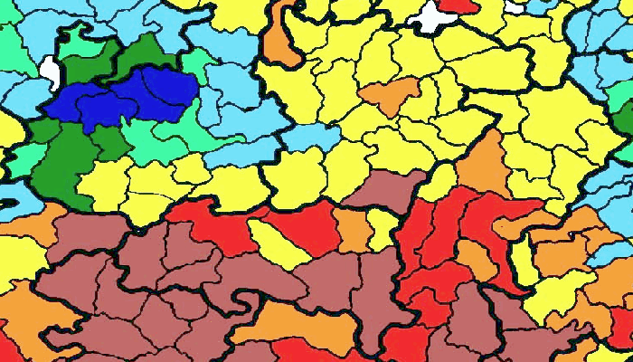
The typical IMD map of 'normal' rainfall measured by the meteorological sub-divisions. The detailed weekly tables give us a very different picture

The typical IMD map of ‘normal’ rainfall measured by the meteorological sub-divisions. The detailed weekly tables give us a very different picture

Methods to simply and accurately funnel this stream of real-time data and imagery are available, mostly at no cost, in order to aid local administrations, farmers and cultivators, and all citizens. It is this availability and relative simplicity of use (block-level weather forecasts for 72 hours are now available as local language apps on smartphones) that must be encouraged by the official agencies – for they simply do not have the persons to do so at the scale and detail required.

Consider the setting in early July 2014. India’s summer monsoon was already late, and where it was late but active it was weak (as shown by the chart). The indications from the central earth science agencies (including the India Meteorological Department), from the Indian Institute of Tropical Meteorology, from the National Centre for Medium Range Weather Forecasting were that it would be end-June before the summer monsoon system settles over central India and the western Gangetic plains. This did not happen for another two weeks, until six of the usual 16 monsoon weeks had passed.

When in mid-July more rainfall was recorded in the districts, even then, as the chart shows, only 50% of the districts reached their ‘normals’ for that week only. Thereafter, the volatility of rainfall set in and while for those in our towns and cities there was relief from the searing summer temperatures the rains did not assure sowing conditions for farmers and cultivators, nor did it add, in July, to the stores of water in major and minor reservoirs.

That is why the IMD’s outdated and stodgy public outreach practice must be overhauled, completely. The bland map (see example) of sub-divisions is of little use when what we want to know pertains to tehsil and town. The Met Department’s rain adequacy categories must be replaced too by measures that are geared towards aiding alerts and advisories – ‘normal’ is rainfall up to +19% above a given period’s average and also down to -19% from that same average, a range that can make or break the efforts of a horticulturist.

This table illustrates the trend of weekly rainfall in 40 districts. These districts are selected as being home to the largest rural populations, two from the 20 major states (by population). The numbers by week and district describe how far from a 'normal' the recorded rainfall for that week was. Several overall observations stand out. Districts with weeks coloured light rose dominate, for these show those that received much less rain than they should have. Districts with a shade of deeper blue are the next most frequent category, and those received excess rain. Taken together, this tells us that extremes - very much less or more - were common for this group of districts in India with large rural populations. We can see the prolonged dry spells for districts in Haryana and Punjab; likewise the absence of rain for the first six monsoon weeks in Gujarat and Maharashtra; are examples of wide swings around weekly 'normal' in Giridih (Jharkhand), Muzaffarpur (Bihar), Haridwar (Uttarakhand), Mandi (Himachal Pradesh), Viluppuram (Tamil Nadu), and Mahbubnagar (Andhra Pradesh). The weeks ending 20 August in Bihar and the weeks ending September 3 and 10 in Jammu and Kashmir immediately stand out - the Kosi had breached its banks in Bihar and the Chenab submerged Srinagar and Jammu.

This table illustrates the trend of weekly rainfall in 40 districts. These districts are selected as being home to the largest rural populations, two from the 20 major states (by population). The numbers by week and district describe how far from a ‘normal’ the recorded rainfall for that week was.
Several overall observations stand out. Districts with weeks coloured light rose dominate, for these show those that received much less rain than they should have. Districts with a shade of deeper blue are the next most frequent category, and those received excess rain. Taken together, this tells us that extremes – very much less or more – were common for this group of districts in India with large rural populations.
We can see the prolonged dry spells for districts in Haryana and Punjab; likewise the absence of rain for the first six monsoon weeks in Gujarat and Maharashtra; are examples of wide swings around weekly ‘normal’ in Giridih (Jharkhand), Muzaffarpur (Bihar), Haridwar (Uttarakhand), Mandi (Himachal Pradesh), Viluppuram (Tamil Nadu), and Mahbubnagar (Andhra Pradesh). The weeks ending 20 August in Bihar and the weeks ending September 3 and 10 in Jammu and Kashmir immediately stand out – the Kosi had breached its banks in Bihar and the Chenab submerged Srinagar and Jammu.

Likewise, excess is +20% and more, deficient is -20% to -59% and scanty is -60% to -99%. To illustrate how misleading these categories can be, the difference between an excess of +21% and +41% can be the difference between water enough to puddle rice fields and a river breaking its banks to ruin those fields. [Get a full resolution image of the table here, 1.85 MB.]

The yawning gap between the technical competence of India’s climate monitoring systems, and they ways in which they are used, must be bridged and this is best done through public participation and citizen initiative. The politics of monsoon and of water will continue, but must not be allowed to define how our systems are used. Nor must they detract from our long history of weather observation, which dates back at least to the ‘Vrhat Sanhita’ of Varahamihira.

It has only signalled policy confusion for central and state governments to have not declared districts and talukas as affected by drought – which they should have by late July 2014 – while at the same time quietly announcing to administrations, as the Ministry of Agriculture did, that “to deal with challenges posed by delayed and aberrant monsoon and in the wake of shortfall in sowing of major crops during kharif 2014, the government has initiated interventions”. These being a diesel subsidy for what is called ‘protective irrigation’ of crops, raising the ceiling on the seed subsidy, rolling out a drought mitigating programme for horticulture, boosting fodder cultivation through the flagship Rashtriya Krishi Vikas Yojana.

The new government has stated time and again its desire to improve and strengthen governance. This must come to include a concerted drive to democratise the use of public domain information, including our monsoon and water, in order that we residents of 4,041 statutory towns (large cities included) and 3,894 census towns can judge for ourselves the relationships between the food we buy, they rain we receive, our individual use of about 70 litres of water a day, and the fluctuation of these trends from one monsoon to another. The moral of monsoon 2014 is that we must reclaim local measures for local use.

Rahul Goswami

Filed Under: Latest, Monsoon 2014 Tagged With: 2014, administration, agriculture, crop, district, ground water, health, IMD, India, krishi, meteorology, monsoon, policy, remote sensing, river, sanitation, smartphone, varahamihira, vrhat samhita, water, watershed, weather station

Dry tale of ten rain weeks

August 23, 2014 by Climate portal editor Leave a Comment


RG_ICP_20140823_pic

What a monsoon season is can no longer be judged by the over-simplified sums that assure the country about departures from an ‘average’ and the potential of ‘catching up’ as a season progresses. Since the 2009 drought, the awareness of farmers’ cooperatives and groups about the meteorological products and data available with the only provider of such measurements has grown. What has not grown is the willingness of government agencies on the one hand, and the consuming public on the other, to make similar investments in pursuing such clarity.

The area chart with its jagged stripes is the simplest indicator of the gap between the central government’s sanguine response to a very serious monsoon deficit, and the conditions that our districts have recorded since the first week of June 2014. The chart, based on the Indian Meteorological Department’s weekly district recordings of rainfall, plots 641 of these readings over ten weeks.

Our modified monsoon measure shows the overall trend, and made the case early for state and district level relief.

Our modified monsoon measure shows the overall trend, and made the case early for state and district level relief.

It is immediately clear that the green stripe (for ‘normal’) has at no point been significantly larger than any one of the other three important stripes, coloured deep red (for ‘scanty’), peach (for ‘deficient’) and blue (for ‘excess’).

In the seventh week of monsoon 2014 (17 to 23 July 2014) the number of districts that recorded normal rainfall for that week was 126, and that is the maximum number that have reported normal rainfall for a week. The next highest number of districts reporting normal for a week is 92, which was for the preceding week (10 to 16 July 2014).

More serious is the district-level reporting for the following three weeks – ending 30 July, 06 August and 13 August – which show the number of districts that reported normal rain for each week was less than 20% of the number of districts that reported deficient, scanty or excess rainfall. It was during this period that central government ministries and agencies did not publicly disclose the widespread monsoon deficiency and which did not act, by alerting the consuming public, to the short and medium term consequences of the monsoon crisis.

The modified monsoon measure (which has been advocated as a method to prime local administrations towards early recognition of the need for relief and remedial action in drought and drought-like conditions) displays to greater effect the glaring imbalance between ‘normals’ and their absence in the districts. In every one of the ten weeks, the light red bar (the ‘deficient 2’ measure, for rainfall of 21% less and lower) dominates.

Otherwise it is the dark blue bar (the ‘excess 2’ measure, for rainfall of 21% more and above) which is next most prominent. This is the clearest signal from a close reading of the district rainfall reportage that volatility in rainfall quantities is the feature most visible throughout monsoon 2014.

The IMD’s running table of the distict rainfall departures confirms this trend for monsoon 2014. In many of the 36 meteorological sub-divisions, weeks of scanty and deficient rainfall are broken by normal or excess rainfall, only to return to scanty and deficient. Taking the districts of Odisha and of western Madhya Pradesh as examples, this volatility can be seen at a glance, and is in concurrence with the overall trends that the modified monsoon measure has been indicating for the last two months.

IMD_weekly_ODI_MP_sm

Filed Under: Current, Monsoon 2014 Tagged With: 2014, agriculture, district, drought, IMD, India, inflation, kharif, monsoon, rabi, rainfall

How ADB cooks the climate pot

August 21, 2014 by Climate portal editor 1 Comment

RG_ICP_pic_20140821

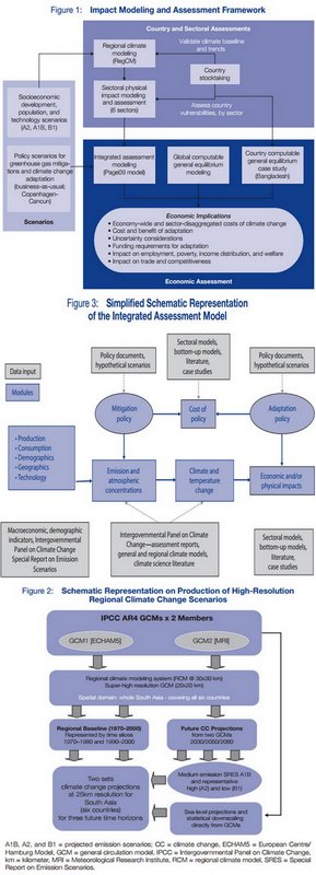
The Asian Development Bank has, amongst the world’s multilateral development banks, been a bit of a latecomer to the area of climate financing with the help of modelling. Its senior peers – the World Bank and the European Bank for Reconstruction and Development – have been at it for a while, with the World Bank being rather in its own league if one was to judge by the tonnage of reports it has printed. The ADB probably holds its own on the matter against the Inter-American Development Bank and the African Development Bank, but this latest effort, I think, pushes it ahead of the last two.

Not for any reason that would gladden a farmer or a municipal worker, for that is not the audience intended for ‘Assessing the costs of climate change and adaptation in South Asia’ (Asian Development Bank, 2014), which was released to the Asian world a few days ago. But the volume should immensely help the modelling crews from a dozen and more international agencies that specialise in this arcane craft. Providing the scientific basis around which a multilateral lending bank can plan its climate financing strategies will help the craft find a future. Rather less sunny is the outlook for states and districts, cities and panchayats, who may find an over-zealous administrator or two quoting blithely from such a report while in search of elusive ‘mitigation’.

The reassuring shapes of indecipherable models

The reassuring shapes of indecipherable models

In my view, this volume is useless. It is so because it is based on a variety of modelling computations which have their origin in the methods used for the IPCC’s Fourth Assessment Report (that was released in 2007). The permanent problem with all such ‘earth science’ modelling approaches is that it uses global data sets which must be ‘downscaled’ to local regions. No matter how sophisticated they are claimed to be by their inventors and sponsors, such models can only work with regular and large sets of well-scrubbed data that have been collected the same way over a long period of time and recorded reliably. This may serve a ‘global’ model (which is irrelevant to us in the districts) but in almost every single case of ‘downscaling’, a scaling down may make a smattering of sense if there is some comparable data relating to the region for which the scaling is taking place. And this correlation, I can assure you, is not possible 99 times out of 100.

But that doesn’t bother the ADB, because it is a bank, it must find a way for Asian countries to agree to taking loans that help them mitigate the effects of rampaging climate change, as this report tries to convince us about. Which is why the ADB has said its unimpeachable analysis is based on “a three-step modeling approach” and this is “(i) regional climate modeling (ii) physical impact assessment, and (iii) economic assessment”, the last aspect being what they’re betting the thermometer on.

The numbers that have emerged from the ADB’s computable general equilibrium model must be satisfyingly enormous to the bank’s thematic project directors and country directors. For the scenario modellers have provided the ammunition for the bank to say: “The region requires funding with the magnitude of 1.3% of GDP on average per annum between 2010 and 2050 under the business-as-usual-1 scenario. The cost could rise to up to 2.3% (upper range) of GDP per annum taking into account climate uncertainties. To avoid climate change impact under the business-as-usual-2 scenario, adaptation cost of around $73 billion per annum on the average is required between now and 2050.”

I could not, in this needlessly dense and poorly written volume, find a mention of which rice strains have been measured for their yields in the example given for India, when the ADB report makes some dire forecasts about how yields will be lowered or will plunge under several forecast conditions. Perhaps they were buried in some footnote I have overlooked, but considering that the International Rice Research Institute (one of the more dangerous CGIAR monster institutes) has in its genebank more than 40,000 varieties from India, and considering that rice conservationist Debal Deb cultivates 920 varieties himself, the ADB (and its modelling troupe) talking about rice ‘yield’ means nothing without telling us which variety in which region. And that sort of negligence naturally leads me to ask what sort of thermometers they consulted while assembling these models.

– Rahul Goswami

Filed Under: Blogs, Latest Tagged With: ADB, agriculture, Asian Development Bank, climate, climate finance, GDP, India, modelling, scenario

  • 1
  • 2
  • Next Page »

Indiaclimate twitter

Tweets by @Indiaclimate

Notable

Between contemplation and climate

Whether or not the USA, Europe, the Western world, the industrialised Eastern world (China, Japan, South Korea, Taiwan), adhere to or not their paltry promises about being more responsible concerning the factors that lead to climate change, is of very little concern to us. We have never set any store by international agreements on climate […]

The ‘Hindu’, ignorant about weather and climate, but runs down IMD

We find objectionable the report by ‘The Hindu’ daily newspaper accusing the India Meteorological Department of scientific shortcoming (‘IMD gets its August forecast wrong’, 1 September 2016). The report claims that the IMD in June 2016 had forecast that rains for August would be more than usual but that the recorded rain was less than […]

dialogue

  • Misreading monsoon | Resources Research on Misreading monsoon
  • Satish on A tribute to the weathermen of Bharat
  • Climate portal editor on A tribute to the weathermen of Bharat
  • Climate portal editor on A tribute to the weathermen of Bharat
  • Climate portal editor on A tribute to the weathermen of Bharat

Categories

Copyright © 2025 indiaclimateportal.org.