The India Climate Observatory

Commentary, action and research on climate and development in India

  • Home
  • About
  • Monsoon 2018
  • Current
  • Bulletin
  • Contact
  • Announcements

A mixed report for the monsoon so far

August 6, 2018 by Climate portal editor Leave a Comment

The India Meteorological Department in its ‘Long Range Forecast for the Rainfall during Second Half (August –September) of the Southwest Monsoon 2018’ has said:
(a) The rainfall during August 2018 is likely to be 96 ± 9% of LPA and expected to be higher than was predicted in June.
(b) Quantitatively, the rainfall for the country as a whole during the second half of the season (August and September) is likely to be 95% of LPA with a model error of ±8%.
(c) The tercile probability forecasts for the rainfall over the country as a whole during the 2018 second half of the monsoon season are: 47% forecast probability that it will be less than 94% of the LPA (below normal), 41% forecast probability that it will be between 94% and 106% of the LPA (normal), and only 12% forecast probability that it will be over 106% of the LPA (above normal).
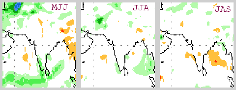
The Department said that “distribution of rainfall is very good over all parts of the country except Bihar, Jharkhand and NE States. Such a scenario of favourable distribution of rainfall is expected to continue during rest of monsoon season of 2018 so as to remain favourable for agricultural operations”.

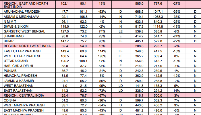
The IMD in its latest weekly ‘performance sheet’ on rainfall has calculated the cumulative rainfall up to 1 August 2018 on an ‘area weighted’ basis as being 431 mm as compared with a normal of 462 mm. But this is a measure that doesn’t tell us anything local and we have advised the IMD to abandon it. What is more useful is the enumerating of subdivisions according to cumulatie rainfall: by 1 August, there were 28 which had normal rainfall, 7 which had deficient, and one which had excess. For this period – monsoon rainfall until 1 August – this year has had the most number of subdivisions with normal rainfall in the last five years.

However it is a concern that five of the seven subdivisions which up to 1 August 2018 have had deficient rainfall are in the East and North-East India region and they are: Arunachal Pradesh (-36%), Assam and Meghalaya (-33%), NMMT which is Nagaland Manipur Mizoram Tripura (-25%), Jharkhand (-24%) and Bihar (-22%). The other two subdivisions with deficits are Rayalaseema (-41%) and Lakshadweep (-43%).

In states, Uttar Pradesh has the largest number of districts (26) registering deficient rainfall up to 1 August 2018, even though 25 of the state’s districts have had normal rainfall for the period and 18 have had excess or large excess. Bihar has 24 districts which have registered deficient rainfall for this period, followed by Jharkhand (15), Assam (14), and Gujarat, Tamil Nadu and Karnataka each with 13.

Filed Under: Latest, Monsoon 2018 Tagged With: 2018, distribution, IMD, India, monsoon, rainfall, subdivision

Three views of monsoon 2018

May 14, 2018 by Climate portal editor Leave a Comment

The India Meteorological Department (IMD) on 16 April had issued its first long range forecast for the 2018 South-West Monsoon season, which the IMD has historically taken to be 1 June to 30 September. The IMD had said that the “monsoon seasonal rainfall is likely to be 97% of the Long Period Average with a model error of ± 5%”. The IMD had also said that its forecast “suggests maximum probability for normal monsoon rainfall (96%-104% of the long period average) and low probability for deficient rainfall during the season”.

In early June, the IMD will issue its second long range forecast for the 2018 monsoon. Until then, we have studied three of the more reliable (in our view) international multi-model ensemble forecasts for the monsoon. What are ensemble forecasts? Each consists of several separate forecasts (some ensembles use 50) forecasts made by the same computer model – these are run on super-computers such as the High Performance Computer System of the Ministry of Earth Sciences (one is at the Indian Institute of Tropical Meteorology in Pune with 4.0 petaflops capacity and the other at the National Centre for Medium Range Weather Forecasting in Noida with 2.8 petaflops capacity).

The MME forecast is based on estimated precipitation anomalies relative to the period 1993-2016, based on initial conditions calculated at the beginning of May 2018. Four blocks of three months each.

The separate forecasts that make up one ensemble are all activated from the same starting time. The starting conditions for each differ from each other to account as far as possible for the staggering number of climatological, atmospheric, terrestrial and oceanographic variables that affect and influence our monsoon. The differences between these ensemble members tend to grow as the forecast travels two, three, four and more months ahead of the present.

We have considered the ensemble forecasts for the 2018 monsoon of the Multi-Model Ensemble (MME) of the USA National Centers for Environmental Prediction, the NOAA Climate Prediction Center and the European Centre for Medium-Range Weather Forecast (ECMWF). In this order, we find that the MME is optimistic, the NOAA CPC is largely neutral and the ECMWF forecast is somewhat pessimistic. The forecasting periods are in blocks of three months.

Here are the details:

(1) The MME forecast, precipitation anomalies relative to the period 1993-2016, based on initial conditions calculated at the beginning of May 2018.
June July August (JJA) – west coast and Konkan, coastal Andhra Pradesh and Odisha, West Bengal, part of the North-East, the entire upper, middle and lower Gangetic region (Uttarakhand, Himachal, Uttar Pradesh, Bihar, Jharkhand), Madhya Pradesh, Chhattisgarh, Maharashtra and Telengana to have up to +1 mm/day. Rest of India other than Gujarat (-0.5 mm/day) normal.
July August September (JAS) – Gujarat to have up to -1 mm/day, Rajasthan up to -0.5 mm/day, Sikkim, Brahmaputra valley and Arunachal Pradesh up to -0.5 mm/day. Himachal Pradesh and Uttarakhand up to +0.5 mm/day, Madhya Pradesh, Odisha, Chhattisgarh, Jharkhand and West Bengal up to +0.5 mm/day. Andhra Pradesh and Tamil Nadu up to -0.5 mm/day.
August September October (ASO) – Gujarat up to -0.5 mm/day. Tamil Nadu up to -1 mm/day. Kerala and adjacent Karnataka up to -0.5 mm/day. Madhya Pradesh, Chhattisgarh, Odisha, West Bengal up to +1 mm/day. Tripura, Mizoram, Manipur, Nagaland, Uttarakhand, Himachal Pradesh up to +0.5 mm/day
September October November (SON) – Tamil Nadu, Kerala and adjacent Karnata up to -1 mm/day. Maharashtra, Madhya Pradesh, Chhattisgarh, Odisha, West Bengal, Himachal Pradesh and Uttarakhand up to +0.5 mm/day.

The NOAA CPC forecast is based on estimated seasonal precipitation anomalies using initial conditions of 30 April 2018 to 9 May 2018. Three blocks of three months each.

(2) The NOAA CPC forecast, seasonal precipitation anomalies using initial conditions of 30 April 2018 to 9 May 2018.
May June July (MJJ) – for most of India a normal reading (+0.5 to -0.5 mm/day fluctuation) and for the west coastal, Konkan, Kerala, south Tamil Nadu and coastal Andhra Pradesh areas variation of up to +1.5 mm/day.
June July August (JJA) – for most of India a normal reading (+0.5 to -0.5 mm/day fluctuation).
July August September (JAS) – normal for most of India. Some areas in the central Deccan plateau, on the west coast and east coast variation of up to -1 mm/day.

The ECMWF forecast is based on estimated mean precipitation anomaly based on climate period data of 1993-2016 and initial conditions as on 1 May 2018. Four blocks of three months each.

(3) The ECMWF forecast, mean precipitation anomaly based on climate period data of 1993-2016 and initial conditions as on 1 May 2018.
June July August (JJA) – all of the southern peninsula and part of the Deccan region (Kerala, Tamil Nadu, Karnataka, Andhra Pradesh, part of Telengana up to -100 mm for the period. West Bengal, Bihar, Jharkhand, Uttar Pradesh up to +100 mm for the period.
July August September (JAS) – all of the southern peninsula and the Deccan region – Kerala, Tamil Nadu, Karnataka, Andhra Pradesh, part of Telengana and Maharashtra up to -100 mm for the period.
August September October (ASO) – Maharashtra, Telegana, Andhra Pradesh and Karnataka up to -100 mm for the period.
September October November (SON) – Central and western India, eastern states and entire Gangetic region up to -50 mm for the period.

Rahul Goswami

Filed Under: Latest, Monsoon 2018 Tagged With: 2018, earth sciences, forecast, IMD, India, meteorology, monsoon

Indiaclimate twitter

Tweets by @Indiaclimate

Notable

Between contemplation and climate

Whether or not the USA, Europe, the Western world, the industrialised Eastern world (China, Japan, South Korea, Taiwan), adhere to or not their paltry promises about being more responsible concerning the factors that lead to climate change, is of very little concern to us. We have never set any store by international agreements on climate […]

The ‘Hindu’, ignorant about weather and climate, but runs down IMD

We find objectionable the report by ‘The Hindu’ daily newspaper accusing the India Meteorological Department of scientific shortcoming (‘IMD gets its August forecast wrong’, 1 September 2016). The report claims that the IMD in June 2016 had forecast that rains for August would be more than usual but that the recorded rain was less than […]

dialogue

  • Misreading monsoon | Resources Research on Misreading monsoon
  • Satish on A tribute to the weathermen of Bharat
  • Climate portal editor on A tribute to the weathermen of Bharat
  • Climate portal editor on A tribute to the weathermen of Bharat
  • Climate portal editor on A tribute to the weathermen of Bharat

Categories

Copyright © 2025 indiaclimateportal.org.