The India Climate Observatory

Commentary, action and research on climate and development in India

  • Home
  • About
  • Monsoon 2018
  • Current
  • Bulletin
  • Contact
  • Announcements

The Indiaclimate Rainfall Index 2019

July 15, 2019 by Climate portal editor Leave a Comment

We have compiled the Indiaclimate District Rainfall Adequacy Index for the monsoon season of 2019. As with our previous editions of the index series, this one for the 2019 monsoon applies our innovation to the communicating of the weekly changes in rainfall adequacy as recorded by the India Meteorological Department (IMD).

The graph (or visualisation as any such illustration is called nowadays, a word that makes the simple graph or chart sound sophisticated, but which usually complicates matters instead of simplifying them) is easy enough to read and interpret. What you have is several vertical bars, each corresponding to dates a week apart. The bars are made up of coloured segments – there are 11 coloured segments and one grey segment, a total of 12 segments.

Each of the 11 colours represents the number of districts whose rainfall readings for a week (the week till the date given) fall within the parameters given in the accompanying legend. There are three groups of colours: three segments in the ‘normal’ ranges, four segments in the ‘excess’ ranges and four segments in the ‘deficient’ ranges. Grey represents no data for that week.

The gradation of the segments is based on, but is not a copy of, the grades used by the UN Food and Agriculture Organisation’s (FAO) Global Information and Early Warning System (GIEWS) indicators for precipitation. The numbers that we use are from the IMD’s Hydrometeorology Division, which releases its ‘rainfall departures’ table every week. We take these numbers, reprocess them and redistribute them across the 11 grades.
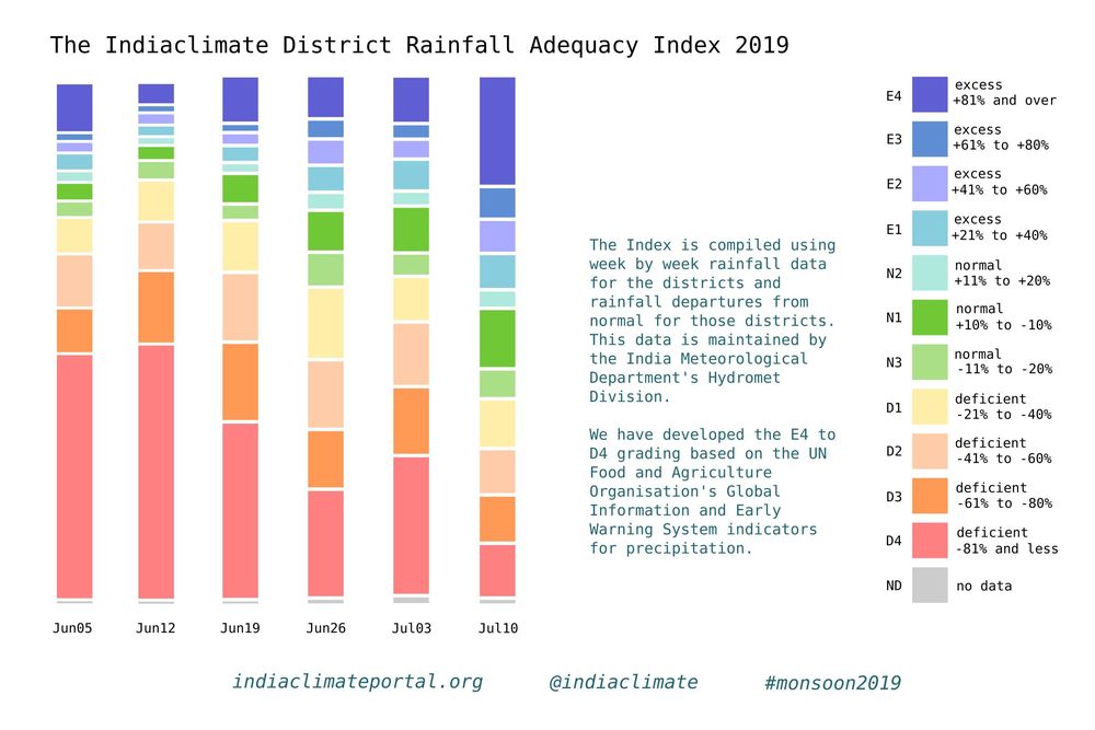
It is a much more readily readable graph and provides for quick interpretation. The grades are finer than the six used by the IMD: normal (+19% to -195), excess (+20% to +59%), large excess (+60% or more), deficient (-20% to -59%), large deficient (-60% to -99%), no rain (-100%).

Our index, in which most segments are of 20 percentage points, is designed for local administrations – in districts but also municipal bodies – to take their cues from weekly signals and prepare if need be for a drought-like situation with water shortages or a flood-like situation with inundation.

How does it work in practice? Let’s look at the district of Guna, in Madhya Pradesh, in the meteorological sub-division of Western MP. The first two monsoon weeks, ending 5 June and 12 June, Guna received no rain (that is, -100% of the rainfall it normally receives in those weeks) and that corresponds to the D4 indicator. The next week, ending 19 June, it received -29% which is D1, the fourth week (26 June) it slipped back to -72% which is D3, the following week (3 July) it improved to -32% which is again D1 and in the sixth week (10 July) Guna received +34% which took it into the E1 grade.

Normally, a district that has received no rainfall or neglible rainfall for six weeks becomes a candidate for a drought-like condition – water sources after the long and hot summer have dried up and crops become parched. If such conditions continue for another two weeks, the state administration must roll out relief measures.

In our example, for the five weeks until the week of 3 July Guna had two D4s, one D3 and two D1s before coming out of the D grades. Our index gives the district (or town) administration the means with which to set their own triggers for action. If the water sources in the district were still at 10%-15% of their water holding capacities by the week of 3 July, then they could consult the medium term forecasts to gauge whether likely rainfall will be enough to hold off relief action. If not, and stored water slipped under 10% with uncertain forecasts, they could ask for relief and issue appropriate crop advisories.
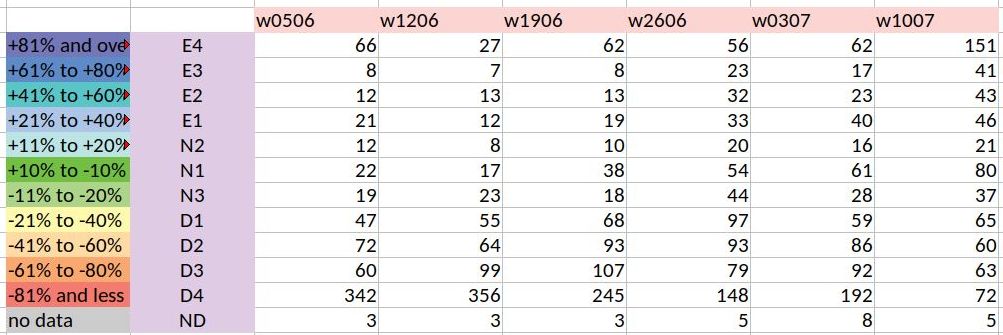
Our index graph – the stacked and segmented bar chart I am sorely tempted to call a ‘signature’ – is a representation of the numbers in the rainweeks table we compile. This table has 684 components which are the districts, each of which has a rainfall reading for the week given (in millimetres) and a rainfall departure (in %). The graph is a set of stacked bars for each week, with each segment sized according to the number of districts in the grade that the segment corresponds to.

What does the index graph for six weeks tell us? The first two monsoon weeks were alarming, with 342 and then 356 districts in the D4 grade. The situation has slowly improved thereafter, with the latest week, that of 10 July, being the best so far – it has 80 districts in the N1 grade. That last week also has for the first time in monsoon 2019 more E grade districts than D grade districts. What needs to be looked out for is districts that have been in the D4 and D3 grades for four and more weeks and whose recovery is patchy. That monitoring becomes much easier with the Indiaclimate District Rainfall Adequacy Index.

Rahul Goswami
Filed Under: Latest, Monsoon 2019 Tagged With: 2019, agriculture, district, drought, flood, India, monsoon, rainfall, water

Late, but on the way

May 28, 2019 by Climate portal editor Leave a Comment

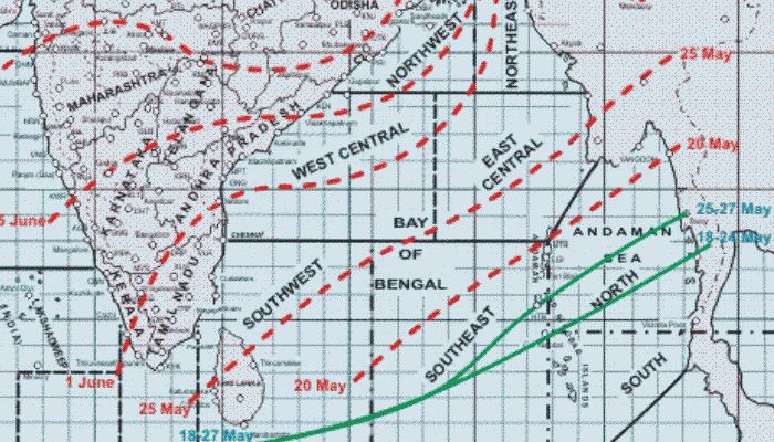
At this point, the monsoon 2019 system is farther away, in terms of its movement, than where it is normally found at this time of the year. The India Meteorological Department maintains its maps showing the movement of the system through late May and early June.

Judged against its averaged movement over the last decade and over a 50-year long-term average, the northern limit of the system is some 450 kilometres away from where it usually is in the south-west Bay of Bengal, and is about 400 kilometres away from the more easterly end of the same perimeter in the east-central Bay of Bengal. Whereas around 27 May the monsoon system would have normally been some 150 kilometres north of the Andaman Islands, now it is at 11N (near Little Andaman).

This delay has no bearing on the forecast for the overall adequacy of rainfall during monsoon 2019 because, as the IMD has said, the large-scale features which influence our monsoon are favourable, these being:
* Weak El Niño conditions that are prevailing over the equatorial Pacific Ocean; the latest Monsoon Mission Climate Forecasting System (MMCFS) forecast indicates that these conditions are likely to continue during the monsoon season but with reduced intensity.
* Neutral Indian Ocean Dipole (IOD) conditions over the Indian Ocean; the latest MMCFS forecast indicates these conditions are likely to continue during the monsoon season.

The weekly outlooks are as follows.
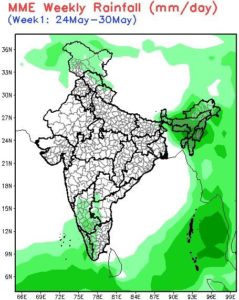
The week 24 May to 30 May: the south-west monsoon cloud cover belt moves into sea regions – the south-east Arabian Sea, the south-west and south-east Bay of Bengal, and the north Andaman Sea. Showers in the entire north-eastern region with heavier daily rain (5-10 mm/day) in Manipur, Nagaland and Assam hills. Light showers in Karnataka, Kerala, adjacent Tamil Nadu and Rayalaseema.

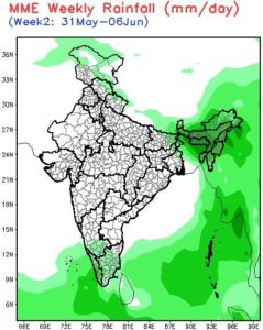
The week 31 May to 06 Jun: the south-west monsoon cloud cover belt does not advance further into the Arabian Sea while it moves further north into the east-central Bay of Bengal. The north-east region continues to have showers as the eastern Himalayan region is fully covered. Lower Assam and Meghalaya to have heavier showers of up to 20 mm/day. The spread of light showers in Tamil Nadu is wider as the north Lankan gap between the cloud fronts over the Arabian Sea and Bay of Bengal closes, light showers (up to 5 mm/day) continue in Kerala and south interior Karnataka.

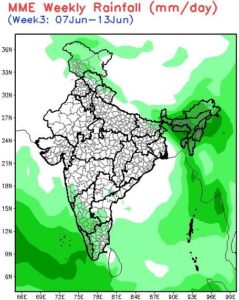
The week 07 Jun to 13 Jun: the main feature is the advance of the south-west monsoon cloud cover belt into the east-central Arabian Sea (off the central Konkan coast). With the limits of the south-west monsoon cloud cover belt remaining as they were over the Bay of Bengal, light showers extend over Tamil Nadu, south interior and coastal Karnataka, Goa and the Maharashtra Konkan with heavier showers (5-10 mm/day in Kerala). All states of the north-east continues to receive heavier showers (10-20 mm/day) and the western Himalaya – all divisions of Jammu & Kashmir, the northern halves of Himachal Pradesh and Uttarakhand – receive light showers.

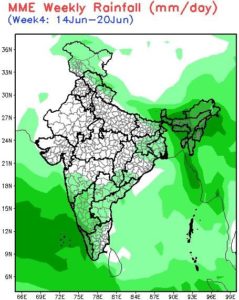
The week 14 Jun to 20 Jun: consolidation of the south-west monsoon cloud cover belt over the seas with the east-central and north-east Arabian Sea fully reached, the north-east Bay of Bengal likewise, and its north-west entered. This brings heavier daily rain (up to 20 mm/day to all states of the north-east and light showers to West Bengal, parts of Bihar, Jharkhand, parts of Odisha. The entire west coast has rain with the northern precipitation line from Thane (20N) to Latur (18N), to Warangal (18N) and Kondagaon (in Chhattisgarh, 20N), to Rayagada (in Odisha, 19N). Light showers also in the western Himalayan region (up to 5 mm/day).

Filed Under: Current, Monsoon 2019 Tagged With: 2019, climate, India, monsoon

Indiaclimate twitter

Tweets by @Indiaclimate

Notable

Between contemplation and climate

Whether or not the USA, Europe, the Western world, the industrialised Eastern world (China, Japan, South Korea, Taiwan), adhere to or not their paltry promises about being more responsible concerning the factors that lead to climate change, is of very little concern to us. We have never set any store by international agreements on climate […]

The ‘Hindu’, ignorant about weather and climate, but runs down IMD

We find objectionable the report by ‘The Hindu’ daily newspaper accusing the India Meteorological Department of scientific shortcoming (‘IMD gets its August forecast wrong’, 1 September 2016). The report claims that the IMD in June 2016 had forecast that rains for August would be more than usual but that the recorded rain was less than […]

dialogue

  • Misreading monsoon | Resources Research on Misreading monsoon
  • Satish on A tribute to the weathermen of Bharat
  • Climate portal editor on A tribute to the weathermen of Bharat
  • Climate portal editor on A tribute to the weathermen of Bharat
  • Climate portal editor on A tribute to the weathermen of Bharat

Categories

Copyright © 2025 indiaclimateportal.org.