The India Climate Observatory

Commentary, action and research on climate and development in India

  • Home
  • About
  • Monsoon 2018
  • Current
  • Bulletin
  • Contact
  • Announcements

India braces for cyclone Hudhud

October 11, 2014 by Climate portal editor Leave a Comment

Insat-3D’s view of the path inland of Hudhud at 1730 IST (5:30pm IST) on 12 October. The cyclonic storm is now moving north-northwest through Odisha into Jharkhand, Chhattisgarh and south Bihar. Image: IMD

Insat-3D’s view of the path inland of Hudhud at 1730 IST (5:30pm IST) on 12 October. The cyclonic storm is now moving north-northwest through Odisha into Jharkhand, Chhattisgarh and south Bihar. Image: IMD

Oct 14 – The Armed Forces have further stepped up their rescue and relief operations in the coastal areas of Andhra Pradesh and Odisha. The Press Information Bureau has reported that eight ‘composite’ Army teams have been deployed in Vishakhapatnam and another eight teams in Srikakulam.
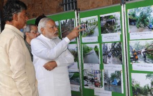
Prime Minister Narendra Modi examining pictures of destruction caused by Cyclone HudHud, at Vizag Collectorate, on 14 October 2014. Image: PIB

Prime Minister Narendra Modi and Andhra Pradesh chief minister N Chandrababu Naidu examining pictures of destruction caused by Cyclone HudHud, at Vizag Collectorate, on 14 October 2014. Image: PIB

The Indian Air Force has deployed C-17, C130J, AN-32, IL-76, Mi-17 and Chetak aircraft and helicopters for rescue and relief work. A total of 120 tonnes of essential supplies have been airlifted to Visakhapatnam from Vijayawada and Rajamundry, while essential supplies have also been marshalled at the Naval airfield at Visakhapatnam. Until the evening of 14 October, 36 sorties were made towards relief operations. Two road clearance teams of Army have been employed in the north of Srikakulum district and the road between Achutapuram and Vizag has been cleared by the armed forces teams.

An aerial survey was conducted by C-130J of the IAF and P-8I of the Navy with satellite imagery having been used to assess the impact of cyclone Hudhud while coastal reconnaissance is being done by the Coast Guard. Additional Engineer Units of the Army are being flown to Visakhapatnam.

Oct 12 – The IMD has issued its evening alert on cyclone Hudhud. The 1700 IST (5:00pm IST) alert contains a heavy rainfall warning and a wind warning.

Heavy rainfall warning: Rainfall at most places with heavy (6.5-12.4 cm) to very heavy falls (12.5-24.4 cm) at a few places and isolated extremely heavy falls (>24.5 cm) would occur over West and East Godavari, Visakhapatnam, Vijayanagaram and Srikakulam districts of north Andhra Pradesh and Ganjam, Gajapati, Koraput, Rayagada, Nabarangpur, Malkangiri, Kalahandi, Phulbani districts of south Odisha during next 24 hrs. Rainfall would occur at most places with heavy to very heavy rainfall at isolated places over Krishna, Guntur and Prakasham districts of Andhra Pradesh and north Odisha during the same period. Rainfall at most places with heavy falls at a few places would occur over south Chattisgarh, adjoining Telangana and isolated heavy to very heavy falls over north Chattisgarh, east Madhya Pradesh, Jharkhand and Bihar.

Cyclone Hudhud will degrade into a severe cyclonic storm, then a cyclonic storm and by 13 October morning into a deep depression. Until 14 October it will continue to pose a danger with heavy rainfall and high winds. This IMD table explains why.

Cyclone Hudhud will degrade into a severe cyclonic storm, then a cyclonic storm and by 13 October morning into a deep depression. Until 14 October it will continue to pose a danger with heavy rainfall and high winds. This IMD table explains why.

Press Information Bureau distributes very useful railway helpline numbers.

Press Information Bureau distributes very useful railway helpline numbers.

Wind warning: Current gale wind speed reaching 130-140 kmph gusting to 150 kmph would decrease gradually to 100-110 kmph gusting to 120 kmph during next 3 hours and to 80-90 kmph during subsequent 6 hours over East Godavari, Visakhapatnam, Vizianagaram and Srikakulam districts of North Andhra Pradesh. Wind speed of 80-90 kmph gusting to 100 kmph would prevail over Koraput, Malkangiri, Nabarangpur and Rayagada districts during next 6 hrs and 50 to 60 kmph during subsequent 12 hrs. Squally wind speed reaching upto 55-65 kmph gusting to 75 kmph would also prevail along and off West Godavari and Krishna districts of Andhra Pradesh, Ganjam and Gajapati districts of Odisha, south Chattisgarh and adjoining districts of north Telangana during next 12 hours.

Andhra Pradesh helpline numbers here. (Thanks to Ankur Singh ‏@ankurzzzz)

Andhra Pradesh helpline numbers here. (Thanks to Ankur Singh ‏@ankurzzzz)

Odisha district control room phone numbers have been distributed thanks to eodisha.org.

They are: Mayurbhanj 06792 252759, Jajpur 06728 222648, Gajapati 06815 222943, Dhenkanal 06762 221376, Khurda 06755 220002, Keonjhar 06766 255437, Cuttack 0671 2507842, Ganjam 06811 263978, Puri 06752 223237, Kendrapara 06727 232803, Jagatsinghpur 06724 220368, Balasore 06782 26267, Bhadrak 06784 251881.

There are reports on twitter that the leading edge of cyclone Hudhud crossed the coast at around 1030 IST (0500 UTC). The reported maximum wind speed is just above 200 kmph which means the destructive force threatens structures too.

Strangely calm right Now. Everything outside is eerily quiet. We’re IN THE EYE of the storm now #Cyclone #Hudhud #Vizag #Visakhapatnam

— Deepa Ghosh (@deepaghosh2007) October 12, 2014

This tweet means the western ‘wall’ of the cyclone has now crossed completely – it has taken just under two hours. The eastern ‘wall’ crossing will now begin.

Cyclone #Hudhud hits the coast of Andhra Pradesh at Kailashgiri in Visakhapatnam. Live updates http://t.co/FQU6kZvVSR pic.twitter.com/YGzZYwIUpg

— Sudhan Rajagopal BJP (@BJPsudhanRSS) October 12, 2014

Cyclone #Hudhud makes landfall at Bheemunipatanam, slightly north of Vizag. #TVnews

— Saswat K Swain (@saswat28) October 12, 2014

Roofs of houses fly away like leaves, huge trees falling everywhere #Hudhud creating maximum destruction.

— Imran Baig (@imranbaig) October 12, 2014

Navy officials warn that there will be a lull in the storm at around 11.30 am, but the storm will again intensify after that for a few hours.
Zee News has a list of cancelled and curtailed trains.
At least 400,000 people have been evacuated from the coastal areas of Andhra Pradesh and Odisha states as authorities aimed for zero casualties.

Oct 11 -Where is Cyclone Hudhud and how fast is it moving towards land? The India Meteorological Department has said in its most recent alert – 1430/2:30pm on 11 October – that “the Very Severe Cyclonic Storm” is now about 260 kilometres south-east of Visakhapatnam and 350 km south-south-east of Gopalpur. IMD expects the cyclone to travel north-west and cross the coast of north Andhra Pradesh, near Visakhapatnam, by mid-morning on 12 October 2014.

The projected path of the cyclone and its outer rainbands, which in the case of Hudhud are around 80 km thick measured from the eye. Image: GDACS

The projected path of the cyclone and its outer rainbands, which in the case of Hudhud are around 80 km thick measured from the eye. Image: GDACS

Around 100,000 people have been evacuated in Andhra Pradesh to high-rise buildings, shelters and relief centres, with plans to move a total of 300,000 to safety. Authorities in Odisha said they were monitoring the situation and would, if necessary, move 300,000 people most at risk.

The evacuation effort was comparable in scale to the one that preceded Cyclone Phailin exactly a year ago, and which was credited with minimising the fatalities to 53. When a huge storm hit the same area 15 years ago, 10,000 people died.

Authorities have been stocking cyclone shelters with dry rations, water purification tablets and generators. They have opened up 24-hour emergency control rooms and dispatched satellite phones to officials in charge of vulnerable districts.

IMD’s table of wind speeds at the surface (sea level) brought by Hudhud. Note the exceptionally strong winds between 2330/11:30pm on 11 October and 1130/11:30am on 12 October.

IMD’s table of wind speeds at the surface (sea level) brought by Hudhud. Note the exceptionally strong winds between 2330/11:30pm on 11 October and 1130/11:30am on 12 October.

The AP government has cancelled leaves of employees and has asked everyone to remain on duty on the weekend.  In Vizag, where the cyclone is expected to make landfall, the administration has opened 175 shelters and moved close to 40,000 people from the coastal villages. In Srikakulam, people of 250 villages in 11 mandals which may be affected have been evacuated.

Vishakhapatnam, Bhimunipatnam, Chittivalasa and Konada are expected to face storm surges of over 1 metre. Source: GDACS

Vishakhapatnam, Bhimunipatnam, Chittivalasa and Konada are expected to face storm surges of over 1 metre. Source: GDACS

While human casualties are not expected due to the massive evacuation, power and telecommunication lines will be uprooted leading to widespread disruption. A warning has been issued that flooding and uprooted trees will cut off escape routes, national and state highways and traffic is being regulated to ensure that no one is caught in the flash floods caused by heavy rains.

Officials said that National Disaster Response Force teams have been strategically placed along the coast to be deployed wherever they are required. Railways has cancelled all trains passing through the three districts which are likely to be affected.

The IMD has issued a “Heavy Rainfall Warning” which has said that driven by the cyclonic winds, rainfall at most places along the AP and Odisha coast will be heavy (6.5–12.4cm) to very heavy (12.5–24.4 cm). These places include West and East Godavari, Visakhapatnam, Vijayanagaram and Srikakulam districts of north Andhra Pradesh and Ganjam, Gajapati, Koraput, Rayagada, Nabarangpur, Malkangiri, Kalahandi, Phulbani districts of south Odisha.

This panel of four images shows the wind patterns of the cyclone at different altitudes. Top left is at 1,000 millibars (mb) of atmospheric pressure which is around sea level, top right is at 850 mb which is at around 1,500 metres high, bottom left is at 700 mb which is at around 3,500 metres, and bottom right is at 500 mb which is at around 5,000 metres. The direction of the greenish lines shows the winds rushing into the cyclonic centre. The visualisations have been collected from the ‘earth.nullschool.net’, which visually processes global weather conditions forecast by supercomputers and updated every three hours.

This panel of four images shows the wind patterns of the cyclone at different altitudes. Top left is at 1,000 millibars (mb) of atmospheric pressure which is around sea level, top right is at 850 mb which is at around 1,500 metres high, bottom left is at 700 mb which is at around 3,500 metres, and bottom right is at 500 mb which is at around 5,000 metres. The direction of the greenish lines shows the winds rushing into the cyclonic centre. The visualisations have been collected from the ‘earth.nullschool.net’, which visually processes global weather conditions forecast by supercomputers and updated every three hours.

The India Meteorological Department said on the evening of 10 October that the “Very Severe Cyclonic Storm” is centered near latitude 15.0ºN and longitude 86.8ºE about 470 km east-southeast of Visakhapatnam and 520 km south-southeast of Gopalpur. This was the fix IMD had on the centre of the cyclone at 1430 IST on 10 October 2014.

Here are the salient points from news reports released during the afternoon of 10 October:

Cyclone Hudhud will cross the north Andhra Pradesh coast on October 12 and is expected to make landfall close to Visakhapatnam, according to the Cyclone Warning Centre (CWC) at Visakhapatnam. “It is forecast that Hudhud, which is already a severe cyclonic storm, will intensify into a very severe cyclonic storm in next 12 hours. Hudhud is likely to make landfall on October 12 close to Visakhapatnam,” said IMD’s Hyderabad centre.

Cyclone Hudhud has moved closer to the coast of Odisha and eight districts of the state are likely to be affected by it. The districts likely to be affected by the cyclone are Ganjam, Gajapati, Rayagada, Koraput, Malkangiri, Nabarangpur, Kalahandi and Kandhamal. All these districts have been provided with satellite phones for emergency and constant vigil was being maintained on the rivers like Bansadhara, Rusikulya and Nagabali as heavy rain is expected in southern districts.

With cyclone Hudhud fast approaching the states of Odisha, Andhra Pradesh and Telangana, Union Home Minister Rajnath Singh today spoke to the chief ministers of the three states on the steps being taken to deal with the situation. Odisha Chief Minister Naveen Patnaik sought satellite phones which could be used in case high-speed winds disturbed the telecommunication system.

According to the India Meteorological Department, the wind speeds of cyclone Hudhud will be less than what the east coast experienced during Phailin in October 2013. The wind speed during cyclone Phailin was nearly 210 kmph, which made the cyclone the second-strongest ever to hit India’s coastal region. The country had witnessed its severest cyclone in Odisha in 1999.

Frequent updates and advisories can also be found at GDACS – the Global Disaster Alert and Coordination System (a cooperation framework under the UN umbrella). GDACS provides real-time access to web-based disaster information systems and related coordination tools.

Cities that will directly be affected by cyclone Hudhud are Vishakhapatnam in Andhra Pradesh, Jagdalpur in Chhattisgarh, Vizianagaram in AP, Bhogapuram in AP, and Anakapalle in AP.

Filed Under: Current, Latest, Monsoon 2014 Tagged With: Andhra Pradesh, Bay of Bengal, Chandrababu Naidu, cyclone, cyclonic storm, disaster, emergency, evacuation, flood, Gajapati, Ganjam, Godavari, Hudhud, IMD, Kalahandi, Koraput, Malkangiri, Modi, Nabarangpur, Odisha, Phailin, Phulbani, Rayagada, relief, Srikakulam, storm, Vijayanagaram, Visakhapatnam

A report card on monsoon 2014

October 1, 2014 by Climate portal editor Leave a Comment

RG_ICP_districts_table_201410From the first week of June 2014 until the middle of September 2014, there have been floods and conditions equivalent to drought in many districts, and for India the tale of monsoon 2014 comes from a reading of individual districts, not from a national ‘average’ or a ‘cumulative’. [This article was published by the newspaper DNA.]

Despite the advances made by our agencies in weather forecasting and climate monitoring, the science of meteorology still remains to be effectively distilled so that it can be used by citizens and, wherever possible, expanded and given context by ground-based observation and recording. One sector in which this does take place – albeit at a level still far below its potential – is agriculture. The reason is clear: our crop staples (the cereals, pulses, vegetables and fruit) have their individual calendars for preparation, sowing, tending and harvesting.

This line chart tells some of the tale. It shows that for the first six weeks of monsoon 2014, most districts recorded rain below their 'normals' for those weeks. The lines are percentile lines; they tell us what percent of districts recorded how much rainfall in a monsoon week relative to their normals for that week. This chart does not show how much rain - it shows distance away from a weekly normal for districts. The left scale is a percentage - higher percentages indicate how far above normal districts recorded their rainfall, negative numbers show us how far below normal their rainfall was. The dates (the bottom scale) are for weeks ending on that date for which normals and departures from normal were recorded. The P_01 to P_09 lines are the percentiles (10th to 90th) of all districts in every week.

This line chart tells some of the tale. It shows that for the first six weeks of monsoon 2014, most districts recorded rain below their ‘normals’ for those weeks. The lines are percentile lines; they tell us what percent of districts recorded how much rainfall in a monsoon week relative to their normals for that week. This chart does not show how much rain – it shows distance away from a weekly normal for districts.
The left scale is a percentage – higher percentages indicate how far above normal districts recorded their rainfall, negative numbers show us how far below normal their rainfall was. The dates (the bottom scale) are for weeks ending on that date for which normals and departures from normal were recorded. The P_01 to P_09 lines are the percentiles (10th to 90th) of all districts in every week.

And so we have an agricultural meteorology system that faithfully and reliably informs ‘kisans’ and cultivators in 641 districts what to expect from the weather for the next week. Thanks to mobile phones, weather alerts and crop advisories are distributed in all our major languages to a portion of the farming households working on 138 million farm holdings, (of which 117 million are small). But this is still only a portion, and is far from adequate in distributing the results of the work of our earth scientists and field staff.

Moreover, every other sector of development requires such raw data and location-specific analysis: the Department of Rural Development, the National Rural Health Mission, the Nirmal Bharat Abhiyan (for drinking water and sanitation), the food-based programmes (like the mid-day meals) for which the availability of ingredients and their supply is the essence of their work, the Central Water Commission and the Central Ground Water Board, whose work it is to determine the water flows and balances in river sub-basins and watersheds (there are 3,257), and districts administrations (which administer 232,855 panchayats) and municipal councils alike which must implement relief measures when drought sets in or must ration supply when there are shortages. This is but a small list of agencies whose work is directly affected by the Indian summer monsoon and its activity where they work.

A dense network of weather stations (more of these are being automated every month, but every taluka still does not have one) is complemented by dedicated satellites which provides continuous coverage of the sub-continent, the northern Asian land mass, the surrounding oceans southwards until beyond the Tropic of Capricorn.

The typical IMD map of 'normal' rainfall measured by the meteorological sub-divisions. The detailed weekly tables give us a very different picture

The typical IMD map of ‘normal’ rainfall measured by the meteorological sub-divisions. The detailed weekly tables give us a very different picture

Methods to simply and accurately funnel this stream of real-time data and imagery are available, mostly at no cost, in order to aid local administrations, farmers and cultivators, and all citizens. It is this availability and relative simplicity of use (block-level weather forecasts for 72 hours are now available as local language apps on smartphones) that must be encouraged by the official agencies – for they simply do not have the persons to do so at the scale and detail required.

Consider the setting in early July 2014. India’s summer monsoon was already late, and where it was late but active it was weak (as shown by the chart). The indications from the central earth science agencies (including the India Meteorological Department), from the Indian Institute of Tropical Meteorology, from the National Centre for Medium Range Weather Forecasting were that it would be end-June before the summer monsoon system settles over central India and the western Gangetic plains. This did not happen for another two weeks, until six of the usual 16 monsoon weeks had passed.

When in mid-July more rainfall was recorded in the districts, even then, as the chart shows, only 50% of the districts reached their ‘normals’ for that week only. Thereafter, the volatility of rainfall set in and while for those in our towns and cities there was relief from the searing summer temperatures the rains did not assure sowing conditions for farmers and cultivators, nor did it add, in July, to the stores of water in major and minor reservoirs.

That is why the IMD’s outdated and stodgy public outreach practice must be overhauled, completely. The bland map (see example) of sub-divisions is of little use when what we want to know pertains to tehsil and town. The Met Department’s rain adequacy categories must be replaced too by measures that are geared towards aiding alerts and advisories – ‘normal’ is rainfall up to +19% above a given period’s average and also down to -19% from that same average, a range that can make or break the efforts of a horticulturist.

This table illustrates the trend of weekly rainfall in 40 districts. These districts are selected as being home to the largest rural populations, two from the 20 major states (by population). The numbers by week and district describe how far from a 'normal' the recorded rainfall for that week was. Several overall observations stand out. Districts with weeks coloured light rose dominate, for these show those that received much less rain than they should have. Districts with a shade of deeper blue are the next most frequent category, and those received excess rain. Taken together, this tells us that extremes - very much less or more - were common for this group of districts in India with large rural populations. We can see the prolonged dry spells for districts in Haryana and Punjab; likewise the absence of rain for the first six monsoon weeks in Gujarat and Maharashtra; are examples of wide swings around weekly 'normal' in Giridih (Jharkhand), Muzaffarpur (Bihar), Haridwar (Uttarakhand), Mandi (Himachal Pradesh), Viluppuram (Tamil Nadu), and Mahbubnagar (Andhra Pradesh). The weeks ending 20 August in Bihar and the weeks ending September 3 and 10 in Jammu and Kashmir immediately stand out - the Kosi had breached its banks in Bihar and the Chenab submerged Srinagar and Jammu.

This table illustrates the trend of weekly rainfall in 40 districts. These districts are selected as being home to the largest rural populations, two from the 20 major states (by population). The numbers by week and district describe how far from a ‘normal’ the recorded rainfall for that week was.
Several overall observations stand out. Districts with weeks coloured light rose dominate, for these show those that received much less rain than they should have. Districts with a shade of deeper blue are the next most frequent category, and those received excess rain. Taken together, this tells us that extremes – very much less or more – were common for this group of districts in India with large rural populations.
We can see the prolonged dry spells for districts in Haryana and Punjab; likewise the absence of rain for the first six monsoon weeks in Gujarat and Maharashtra; are examples of wide swings around weekly ‘normal’ in Giridih (Jharkhand), Muzaffarpur (Bihar), Haridwar (Uttarakhand), Mandi (Himachal Pradesh), Viluppuram (Tamil Nadu), and Mahbubnagar (Andhra Pradesh). The weeks ending 20 August in Bihar and the weeks ending September 3 and 10 in Jammu and Kashmir immediately stand out – the Kosi had breached its banks in Bihar and the Chenab submerged Srinagar and Jammu.

Likewise, excess is +20% and more, deficient is -20% to -59% and scanty is -60% to -99%. To illustrate how misleading these categories can be, the difference between an excess of +21% and +41% can be the difference between water enough to puddle rice fields and a river breaking its banks to ruin those fields. [Get a full resolution image of the table here, 1.85 MB.]

The yawning gap between the technical competence of India’s climate monitoring systems, and they ways in which they are used, must be bridged and this is best done through public participation and citizen initiative. The politics of monsoon and of water will continue, but must not be allowed to define how our systems are used. Nor must they detract from our long history of weather observation, which dates back at least to the ‘Vrhat Sanhita’ of Varahamihira.

It has only signalled policy confusion for central and state governments to have not declared districts and talukas as affected by drought – which they should have by late July 2014 – while at the same time quietly announcing to administrations, as the Ministry of Agriculture did, that “to deal with challenges posed by delayed and aberrant monsoon and in the wake of shortfall in sowing of major crops during kharif 2014, the government has initiated interventions”. These being a diesel subsidy for what is called ‘protective irrigation’ of crops, raising the ceiling on the seed subsidy, rolling out a drought mitigating programme for horticulture, boosting fodder cultivation through the flagship Rashtriya Krishi Vikas Yojana.

The new government has stated time and again its desire to improve and strengthen governance. This must come to include a concerted drive to democratise the use of public domain information, including our monsoon and water, in order that we residents of 4,041 statutory towns (large cities included) and 3,894 census towns can judge for ourselves the relationships between the food we buy, they rain we receive, our individual use of about 70 litres of water a day, and the fluctuation of these trends from one monsoon to another. The moral of monsoon 2014 is that we must reclaim local measures for local use.

Rahul Goswami

Filed Under: Latest, Monsoon 2014 Tagged With: 2014, administration, agriculture, crop, district, ground water, health, IMD, India, krishi, meteorology, monsoon, policy, remote sensing, river, sanitation, smartphone, varahamihira, vrhat samhita, water, watershed, weather station

Climate change is not the only villain

September 11, 2014 by Climate portal editor Leave a Comment

A woman weeps at the site of her home, devastated by floods in Kuppar village near Jammu, in Jammu and Kashmir, India. Photo: Thomson Reuters Foundation / Ashutosh Sharma

A woman weeps at the site of her home, devastated by floods in Kuppar village near Jammu, in Jammu and Kashmir, India. Photo: Thomson Reuters Foundation / Ashutosh Sharma

About 200 kilometres separates Srinagar, in the valley of Kashmir in India, from the wide and flat northern plains of Pakistan’s Punjab province, the land between Gujranwala and Sialkot. The river that links these two regions, on either side of the border between two countries, is the Jhelum and its many mountain-fed tributaries. From early September, rains that are torrential in volume and frequency for the region steadily fed the streams, swelled the rivers and then rushed through the settlements and towns of northern Pakistan and India.

On both sides of the Pakistan-India border the scene is depressingly similar. The toll of the dead will not be known until the waters drain, and even then will be estimates, as they always are. Until two days ago, 220 or 230 was the number of lives reported lost in both countries. The number of lives disrupted, displaced and reduced to misery is far greater – more than 100,000 have been rescued by the Indian Army in the state of Jammu and Kashmir. In Pakistan too it has been its army that has performed extraordinary feats of rescue and provided relief when every other administrative mechanism failed, but as the waters continued to gather in volume and speed, the September floods are already estimated to have affected more than a million in Pakistan.

A couple wades through a flooded road after heavy rains in Lahore, Pakistan, on 4 September 2014. Photo: Reuters / Mohsin Raza

A couple wades through a flooded road after heavy rains in Lahore, Pakistan, on 4 September 2014. Photo: Reuters / Mohsin Raza

There has been mourning and resignation, for lives lost and for homes destroyed, but there is also anger in both Pakistan’s Punjab and India’s Jammu and Kashmir. Economic need and the search for livelihoods has brought migrants into urban settlements, while older and more established households have sought to better their standards of living. Overlooked every single year, despite at least one emergency caused by natural phenomena, has been implementing the regulations needed for fast-growing settlements in flood-prone regions. Both countries have national disaster management authorities, and yet the complaint most commonly heard by those escaping floodwaters and by those seeking relief is: where was the warning and where was the help when we needed it?

The very recent history in India (the catastrophic rain and landslides in Uttarakhand in 2013) and in Pakistan (the record flooding of 2010) of natural disasters appears not to have led to the institutionalisation of a culture that is willing to learn from past misfortune. In both countries, media has reported scores of survivors praising swift and selfless action by the armed forces and at the same time condemning inaction by local and provincial authorities.

Climate change and its impacts has become a catch-all villain for the record floods and the devastation they have caused (and continue to). But amongst the complex menu of reasons for the failure of systems and responses, several others stand out in bolder relief. The encroachment by galloping urbanisation of river catchment areas, unregistered and illegal construction (both residential and commercial) along river banks and the blind conversion of wetlands into agricultural lands has, in both countries, turned historically familiar floods into fearsome deathtraps.

When the waters ebb and families can reunite, both Pakistan and India must together confront the real reasons behind the destruction and toll wrought by the floods of September 2014.

Filed Under: Latest, Monsoon 2014 Tagged With: army, Chenab, disaster, flood, Gujranwala, India, Jhelum, Kashmir, Lahore, Pakistan, Punjab, river, Sialkot, Srinagar, urban

Flood waters batter North India, Pakistan

September 7, 2014 by Climate portal editor Leave a Comment

RG_ICP_201409_Hindu_JK_4

Women and children being transported in a boat through a flooded road to a safer place during incessant rains in Srinagar. Photo: The Hindu

Four days of very heavy rain has affected districts in northern India and north-eastern Pakistan, causing damage and deaths, and leading to continuing misery in Pakistan. In Jammu and Kashmir, the death toll is 160 while in Pakistan it is 170.

Prime Minister Narendra Modi arrived in Jammu on Sunday to personally review the situation in the flood-hit state after over 160 people lost their lives in the worst floods to affect Jammu and Kashmir in 60 years.

Accumulated rainfall from 2-5 September for the north India and north-eastern Pakistan regions.

Accumulated rainfall from 2-5 September for the north India and north-eastern Pakistan regions.

Floods and landslides, due to very heavy rains, affected parts of Jammu and Kashmir while in Pakistan very heavy rains continue, causing floods in parts of Punjab and Pakistan-occupied Kashmir. Pakistan’s National Disaster Management Authority announced that “Very High to Exceptionally High Flood Level” is likely to continue in the Chenab and Jhelum along with their associated streams for the next two days.

On 4 September a bus, filled to capacity with 52 members of a wedding group, was on its way to Lam, around 120 km from Jammu city, when it was hit by surging waters of the Gambhir river. Only three people survived the accident.

The state capital of Srinagar also braced for major floods with the Jhelum, Kashmir’s main river, flowing more than 2.13 metres (seven feet) above the danger mark. Vast swathes of Srinagar remain inundated. The 300-km-long Jammu-Srinagar national highway also closed for traffic after two landslides in the Ramban district left hundreds of vehicles stranded. South Kashmir’s Anantnag and Kulgam districts are among the worst hit, with at least 50 villages under water.

A flooded ward in Srinagar. Photo: Waseem Andrabi / Hindustan Times

A flooded ward in Srinagar. Photo: Waseem Andrabi / Hindustan Times

The Indian Army has evacuated 11,000 people to safety by deploying 100 columns of troops in flood-hit areas of the state. About 2,000 people have been provided food and temporary shelter in Jammu and Kashmir. A total of 100 Army columns (each column is 75-100 troops), 13 teams of Army engineers are working in the flood-affected regions of the state. The Army’s ‘Mission Sahayata’ is rescuing people trapped in flooded villages, isolated houses and multi-storied buildings in the inundated areas all over Kashmir, with tented shelter being provided to those who have lost their homes to the floodwaters.

Torrential monsoon rains have again wreaked havoc in Pakistan’s largest province Punjab and in Pakistan-administered Kashmir since 4 September. A Pakistan Meteorological Department report given to the Indus River Commission – which looks after Indus, Jhelum and Chenab rivers – said on September 5 that around 0.9 million cusecs (cubic feet per second, equal to over 25,000 cumecs, or cubic metres per second) of additional water was flowing down the Himalayan rivers, according to Ghulam Rasul, Chief Meteorological Officer. Rasul said the floods would have a devastating impact in Kashmir, Punjab and Sindh due to lack of preparations and absence of water management strategies.

Map of the flood-affected areas from the from European Commission Humanitarian Aid department.

Map of the flood-affected areas from the from European Commission Humanitarian Aid department.

However, Sindh and Punjab are expected to face severe flooding in the coming days, the Pakistan Meteorological Department warned on Sunday. A press release issued by the Meteorological Department said that water levels in the Indus River at Sukkur and Guddu Barrage are constantly increasing, and consequently, there will be severe floods on September 13 and 14 in both provinces.

Ahmad Kamal, a spokesman for Pakistan’s National Disaster Management Authority, said at least 69 people have died in the eastern Punjab province since Thursday. He said another 48 people died in the Pakistan-occupied Kashmir and 11 died in northern Gilgit Baltistan province.

Filed Under: Latest, Monsoon 2014 Tagged With: army, Chenab, disaster, flood, India, Jammu, Jhelum, Kashmir, landslide, Pakistan, Ravi, rescue, river, Srinagar

How ADB cooks the climate pot

August 21, 2014 by Climate portal editor 1 Comment

RG_ICP_pic_20140821

The Asian Development Bank has, amongst the world’s multilateral development banks, been a bit of a latecomer to the area of climate financing with the help of modelling. Its senior peers – the World Bank and the European Bank for Reconstruction and Development – have been at it for a while, with the World Bank being rather in its own league if one was to judge by the tonnage of reports it has printed. The ADB probably holds its own on the matter against the Inter-American Development Bank and the African Development Bank, but this latest effort, I think, pushes it ahead of the last two.

Not for any reason that would gladden a farmer or a municipal worker, for that is not the audience intended for ‘Assessing the costs of climate change and adaptation in South Asia’ (Asian Development Bank, 2014), which was released to the Asian world a few days ago. But the volume should immensely help the modelling crews from a dozen and more international agencies that specialise in this arcane craft. Providing the scientific basis around which a multilateral lending bank can plan its climate financing strategies will help the craft find a future. Rather less sunny is the outlook for states and districts, cities and panchayats, who may find an over-zealous administrator or two quoting blithely from such a report while in search of elusive ‘mitigation’.

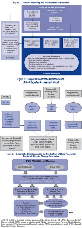
The reassuring shapes of indecipherable models

The reassuring shapes of indecipherable models

In my view, this volume is useless. It is so because it is based on a variety of modelling computations which have their origin in the methods used for the IPCC’s Fourth Assessment Report (that was released in 2007). The permanent problem with all such ‘earth science’ modelling approaches is that it uses global data sets which must be ‘downscaled’ to local regions. No matter how sophisticated they are claimed to be by their inventors and sponsors, such models can only work with regular and large sets of well-scrubbed data that have been collected the same way over a long period of time and recorded reliably. This may serve a ‘global’ model (which is irrelevant to us in the districts) but in almost every single case of ‘downscaling’, a scaling down may make a smattering of sense if there is some comparable data relating to the region for which the scaling is taking place. And this correlation, I can assure you, is not possible 99 times out of 100.

But that doesn’t bother the ADB, because it is a bank, it must find a way for Asian countries to agree to taking loans that help them mitigate the effects of rampaging climate change, as this report tries to convince us about. Which is why the ADB has said its unimpeachable analysis is based on “a three-step modeling approach” and this is “(i) regional climate modeling (ii) physical impact assessment, and (iii) economic assessment”, the last aspect being what they’re betting the thermometer on.

The numbers that have emerged from the ADB’s computable general equilibrium model must be satisfyingly enormous to the bank’s thematic project directors and country directors. For the scenario modellers have provided the ammunition for the bank to say: “The region requires funding with the magnitude of 1.3% of GDP on average per annum between 2010 and 2050 under the business-as-usual-1 scenario. The cost could rise to up to 2.3% (upper range) of GDP per annum taking into account climate uncertainties. To avoid climate change impact under the business-as-usual-2 scenario, adaptation cost of around $73 billion per annum on the average is required between now and 2050.”

I could not, in this needlessly dense and poorly written volume, find a mention of which rice strains have been measured for their yields in the example given for India, when the ADB report makes some dire forecasts about how yields will be lowered or will plunge under several forecast conditions. Perhaps they were buried in some footnote I have overlooked, but considering that the International Rice Research Institute (one of the more dangerous CGIAR monster institutes) has in its genebank more than 40,000 varieties from India, and considering that rice conservationist Debal Deb cultivates 920 varieties himself, the ADB (and its modelling troupe) talking about rice ‘yield’ means nothing without telling us which variety in which region. And that sort of negligence naturally leads me to ask what sort of thermometers they consulted while assembling these models.

– Rahul Goswami

Filed Under: Blogs, Latest Tagged With: ADB, agriculture, Asian Development Bank, climate, climate finance, GDP, India, modelling, scenario

Deadly negligence

August 4, 2014 by Climate portal editor Leave a Comment

A resident looks at the debris of her damaged house after a landslide at Malin village, Pune district, in Maharashtra on 30 July 2014. Photo: Reuters/Stringer

A resident looks at the debris of her damaged house after a landslide at Malin village, Pune district, in Maharashtra on 30 July 2014. Photo: Reuters/Stringer

Two months of monsoon that have delivered rainfall considerably below normal have given way to an end July and early August that has brought torrents of rain in some locations, and with it destruction and the loss of life.

In the last week, there has been a landslide in the Pune district, western Maharashtra, in which the death toll has risen to over 100. There has been a landslide in Nepal, along the Bhote Kosi river, around 120 kilometres from Kathmandu, which is reported to have killed over 100 and displaced thousands. The situation there has led to an emergency in north Bihar, through which the Kosi flows, with some 65,000 people being evacuated from nine districts.

In the Bay of Bengal, 40 trawlers are reported to have gone missing in bad weather; there are estimated to be some 650 fishermen on board the vessels. In the Munshiganj district of central Bangladesh, about 40 kilometres from Dhaka, a ferry on the Padma river sank with about 200 on board.

Every one of these events is repeated every monsoon – landslide, flood, river ferry sinking, fishing trawlers missing at sea – with little indication that learning takes place about how to contain the impacts and how to prepare for them when they become threats.

The threat from the Kosi developed after a massive landslide blocked the main course of Bhote Kosi river, a tributary of the Kosi, in Sindhupalchok district of Nepal. The landslide brought down rock which has dammed the river, immediately forming a large lake. Authorities in Nepal have been trying to release the water without endangering downstream regions.

The central government has said (o4 August Monday) that there is no immediate threat of a flood. India’s Home Ministry, the Nepal Water Commission, India’s Central Water Commission and India’s National Crisis Management Committee are coordinating preparations, relief and technical expertise. The Bihar state government is carrying our the evactuations to avoid a situation like 2008, when a breach in the Kosi embankment at Kushaha in Nepal caused one of the most devastating floods.

The landslide in Nepal and the emergency in downstream Bihar has again revived the debate as to whether a dam would help solve the problem of floods in north Bihar. Since 1945 there have been commissions to study the problem and make their recommendations, and proposed dams have been abandoned for compelling reasons – that the river valleys have unstable foundations, that the region is a high-risk seismic zone, that the reservoirs would silt up far sooner than expected, and that the costs would be prohibitive.

The tragic incidents in Maharashtra, in the Bay of Bengal, and in Munshiganj (Bangladesh) have much more to do with the wilful neglect of conditions that have built up a cumulative threat. The landslide in Pune district which has buried portions of a village, its residents and cattle, was according to a number of media reports the result of factors that included what appears to be no recognition of the most obvious risks. The hill above the village of Malin is reported to have been the site of wind turbines (which need heavy machinery to erect them) and also farming that used heavy equipment to level the top of the hill. Whichever factor is true, the use to which hill land was put was a threat to the settlement at its base, and little thought was given to monsoon conditions.

That such a large group of trawlers went missing in the Bay of Bengal near Kakdwip in South 24 Parganas district of West Bengal has to do with economic reasons, which media reports will at this stage not uncover. Three of the trawlers are reported as having capsized and authorities in West Bengal are said to have ‘traced’ 25 of the vessels. The question is: when squally weather and forecasts of heavy rain trigger warning to fishermen, why do they ignore these warnings and risk their lives? The usual answer is loan economics, for the trawler owners can’t afford delays in servicing the loans with which they bought the vessels, and are under pressure to find and sell fish, which is when safety considerations are ignored.

Similar considerations lead in Bangladesh to riverine ferries – a common mode of transport in great deltas – being overloaded to far beyond their capacities. The monsoon brings with it weather conditions that demand safety first, but when economic desperation and plain greed set in, elementary precautions that are meant to save lives are discarded.

Filed Under: Latest, Monsoon 2014 Tagged With: Bangladesh, Bay of Bengal, Bihar, cyclone, disaster, evacuation, ferry, fishermen, flood, India, Kosi, land use, landslide, Maharashtra, monsoon, Nepal, rehabilitation, rescue, water

Government readies drought plan

July 18, 2014 by Climate portal editor Leave a Comment

The drought management information system is in place and working.

The drought management information system is in place and working.

The Ministry of Agriculture through the Department of Agriculture and Cooperation has released its national drought crisis management plan. This is not taken as the indicator that drought conditions are expected to set in, but to prepare for them where they are identified. In the fifth week of the South-West monsoon, the trend continues to be that week by week, the number of districts that have recorded less rainfall than they normally receive outnumber those districts with normal rainfall. When this happens over a prolonged period, such as four to six weeks, drought-like conditions set in and the administration prepares for these conditions. [Links to the documents are at the end of this posting.]

There are a group of ‘early warning indicators’ for the kharif crop (sowing June to August) which are looked for at this time of the year. They are: (1) delay in the onset of South-West monsoon, (2) long ‘break’ activity of the monsoon, (3) insufficient rains during June and July, (4) rise in the price of fodder, (5) absence of rising trend in the water levels of the major reservoirs, (6) drying up of sources of rural drinking water, (7) declining trend in the progress of sowing over successive weeks compared to corresponding figures for ‘normal years’.

On this list, points 1 and 2 are true, 3 is true for June and July until now, 4 and 5 are true, we have insufficient information for 6 and 7 but from mid-May there have been a number of media reports on water scarcity in the districts of peninsular, central and northern India. Thus the state of the ‘early warning’ indicators taken together have triggered the issuing of the government’s drought crisis management plan.

“The identified priorities of CMP are to clarify the goals and define the roles and responsibilities of various responders (ministries / departments, organisations and individuals) involved in crisis management, and putting together a communication process for quickly notifying the public in the event of a crisis,” the ministry has explained. “The plan outlined in this document does not replace the emergency procedures or contingency action plans already drawn by different agencies, but has been developed to address crisis situations that have the potential for a much greater impact on the nation.”

The reason we have plans at the national and state level, and contingency plans for each district in the event of drought, drought-like conditions, and water scarcity is the combination of several factors:

  • Every year more than 50 million people are directly exposed to drought and its effects, with 16% of India’s total area considered prone to drought.
  • In four out of every ten years rainfall in India is erratic.
  • Drought in varying degrees affects 68% of the sown area.
  • Regions with annual rainfall of 750-1,125 millimetres account for 35% of the land area and are drought prone.
  • Most of these zones lie in the arid (19.6%), semi-arid (37%) and sub-humid (21%) regions of India.
  • Up to three-quarters of the annual average rainfall occurs over 120 days of the year. A third of the total land area receives less than 750 mm of rainfall and is chronically drought prone.

In this ‘warning phase’ – which many districts have entered – the crisis management plan calls for short-term water conservation measures by municipal and district agencies, water-budgeting by the Ministry of Water Resources (Irrigation), the Ministry of Urban Development and by the Department of Drinking Water and Sanitation. Municipal and town councils are instructed to identify alternative sources of water when the town is in a ‘warning’ period and the supply of water may be restricted to 70 litres per person per day (about half of the normal 135). Water rationing and restricted use become urgent with municipal and town councils instructed to ensure that drinking water is not used for other purposes (like washing cars, watering gardens, and so on).

State governments have in place standing instructions of designating officers responsible for meeting the needs of rural and urban citizens during drought and drought-like conditions. This document contains the list of nodal officers of the line ministries and departments, and of the Ministry of Agriculture’s drought management division, with their contact details. The full crisis management plan of the Ministry of Agriculture, Department of Agriculture and Cooperation, is here.

Filed Under: Latest, Monsoon 2014 Tagged With: 2014, contingency, district, drought, India, kharif, ministry, monsoon, municipality, reservoir, sarcity, town, urban development, water resources

New El Niño outlook

July 1, 2014 by Climate portal editor Leave a Comment

Sea surface temperature in the Indian Ocean. Image from the earth|nullschool real time visualisation of wind and ocean conditions

Sea surface temperature in the Indian Ocean. Image from the earth|nullschool real time visualisation of wind and ocean conditions

There is a 60% likelihood of an El Niño being fully established between June and August, increasing to 75-80% for the October to December period, according to an El Niño Update issued by the World Meteorological Organisation (WMO). Many countries have already started preparing for the arrival of El Niño, which is associated with regional-scale drought and flood situations in different parts of the world and has a warming influence on global average surface temperatures.

El Niño is characterised by unusually warm ocean surface temperatures in the central and eastern tropical Pacific, coupled with typical atmospheric circulation patterns. It is a natural phenomenon with a recurring interval of 2-7 years and has a major impact on the climate around the world. The last El Niño was in 2009-2010.

The latest WMO outlooks suggest that central tropical Pacific Ocean surface temperatures are likely to warm further into the third quarter of 2014, while the atmospheric patterns associated with El Niño are also expected to form and strengthen.

The WMO expects that El Niño will reach peak strength during the fourth quarter and endure into the first few months of 2015 before dissipating. The substantially above-average oceanic heat content beneath the sea surface of the central and eastern tropical Pacific Ocean, triggered by strong westerly wind events earlier this year, suggested an event of significant strength. However, the delayed atmospheric response, and a potential lack of subsequent westerly wind events in the coming months, may limit the peak strength of the El Niño, said the WMO.

Already, the second quarter of 2014 set new global atmospheric heat records. According to NASA, this May was the hottest in the global measure, meanwhile, the Japanese Meteorological Agency marked the March-April period as the hottest spring in all of the past 130 years (NASA showed the same period was second hottest). Rising Pacific Ocean surface temperatures by themselves were enough, when combined with raging human greenhouse gas heat forcing, to nudge atmospheric temperatures into a new record range. But the emergence of full-blown El Niño will likely push current record readings even higher.

Filed Under: Latest Tagged With: Climate Change, drought, El Nino, flood, WMO, World Meteorological Organisation

A third dry week of monsoon 2014

June 28, 2014 by Climate portal editor Leave a Comment

05 to 11 June is the first week. 12 to 18 June is the second week. 19 to 25 June is the third week. The bars represent the weeks and are divided by IMD's rainfall categories, with the length of each category in a bar showing the proportion of that category's number of districts. The colours used here match those used in IMD's weekly rainfall map (below) which displays the category-wise rainfall in the 36 meteorological sub-divisions (but not by district).

05 to 11 June is the first week. 12 to 18 June is the second week. 19 to 25 June is the third week. The bars represent the weeks and are divided by IMD’s rainfall categories, with the length of each category in a bar showing the proportion of that category’s number of districts. The colours used here match those used in IMD’s weekly rainfall map (below) which displays the category-wise rainfall in the 36 meteorological sub-divisions (but not by district).

The IMD weekly rainfall map for 19 to 25 June.

The IMD weekly rainfall map for 19 to 25 June.

We now have rain data for three complete weeks from the India Meteorological Department (IMD) and for all the districts that have reported the progress of the monsoon.

The overall picture remains grim. In the third week of the monsoon the number of districts that reported normal rains in that week (-19% to +19% of the average) is only 74. No rain (-100%) was reported by 71 districts Scanty rain (-99% to -60%) was reported by 221 districts, deficient rain (-59% to -20%) was reported by 125 districts, excess rain (+20% and more) was reported by 129 districts, and there was no data from 21 districts.

IMD_districts_table_3_weeksThe Department of Agriculture and Cooperation, of the Ministry of Agriculture, has already issued its guidance to states on the contingency plans to be followed for a delayed monsoon. That is why it is important to make available the district-level normals and rainfall departures – the meteorological sub-divisions are too broad for such analysis and are irrelevant to any contingency plans and remedial work.

By end-June, when the IMD updates its outlook for the rest of monsoon 2014, we expect more detailed assessments of the districts to be publicly available – the agromet (agricultural meteorology section) already provides this to the states, with state agriculture departments given the responsibility of ensuring that the advice – which is especially important for farmers to plan the sowing of crop staples – reaches every panchayat.

Filed Under: Latest, Monsoon 2014 Tagged With: 2014, agriculture, climatechange, contingency, district, drought, food, forecast, IMD, India, inflation, monsoon, rainfall, weather

Emissions, deserts and economics

June 17, 2014 by Climate portal editor Leave a Comment

Desertification in Namibia. Photo: UNEP/A.Gloor/Namibia

Desertification in Namibia. Photo: UNEP/A.Gloor/Namibia

Marking the World Day to Combat Desertification and referring directly to climate change, India today said developing countries like it have “a right to grow” and in the process “our net emission may increase”. Environment Minister Prakash Javadekar made the point that the problem of carbon emission “has not been created by the developing nations and hence responsibility for addressing it should not be solely put on them”.

Javadekar said India does have to reduce carbon emissions but also said that the country has “a right to grow”. He said that poverty is an “environmental disaster” and “unless we tackle poverty, unless we eradicate poverty, we cannot really address the climate change”. The eradication of poverty in India, said the minister, will require India to grow economically and in so doing “our net emission may increase”.

Meanwhile, United Nations officials today emphasised the importance of restoring degrading lands to avoid or soften the potentially disastrous impacts of climate change. The UN mentioned studies which show that 24 billion tons of fertile soil are being eroded each year, and 2 billion hectares of degraded land have potential for recovery and restoration. Furthermore, land degradation is not only a problem in the world’s drylands. Most of the deterioration is happening in humid areas.

With the ongoing impact of global climate change, we will continue to witness extreme weather events, which will in turn lead to even more land degradation. The UN statement on the World Day to Combat Desertification said a commitment to achieving a land-degradation neutral world must be realised through common targets and clear indicators of success.

Javadekar has said that India will become “desertification neutral” by 2030, and added that 32% of India’s total land is facing the threat of desertification. “In India, 69% of the land is dryland, and 32% of the land is undergoing desertification,” he said. According to the Ministry of Environment, Forests and Climate Change, the land area facing desertification is 81 million hectares, while 105 million hectares are dryland. “It is a serious threat and has to be stopped and reversed,” he said. Javadekar said an integrated plan will be launched with the agriculture, land resources and water ministries to address the problem.

The World Day to Combat Desertification (WDCD) is 17 June4. As a signatory to United Nations Convention to Combat Desertification (UNCCD), which focuses on desertification, land degradation and drought, India promotes public awareness of the issue, and mobilises international cooperation for the implementation of the UNCCD. The theme of this year’s WDCD is ecosystem-based adaptation with the slogan ‘Land Belongs to the Future, Let’s Climate Proof It’. The 2014 WDCD highlights the benefits of mainstreaming sustainable land management policies and practices into our collective response to climate change.

Filed Under: Latest Tagged With: carbon, Climate Change, desertification, drought, dryland, emissions, environment, forest, Javadekar, land degradation, ministry, poverty, UNCCD

  • « Previous Page
  • 1
  • 2
  • 3
  • 4
  • 5
  • 6
  • …
  • 88
  • Next Page »

Indiaclimate twitter

Tweets by @Indiaclimate

Notable

Between contemplation and climate

Whether or not the USA, Europe, the Western world, the industrialised Eastern world (China, Japan, South Korea, Taiwan), adhere to or not their paltry promises about being more responsible concerning the factors that lead to climate change, is of very little concern to us. We have never set any store by international agreements on climate […]

The ‘Hindu’, ignorant about weather and climate, but runs down IMD

We find objectionable the report by ‘The Hindu’ daily newspaper accusing the India Meteorological Department of scientific shortcoming (‘IMD gets its August forecast wrong’, 1 September 2016). The report claims that the IMD in June 2016 had forecast that rains for August would be more than usual but that the recorded rain was less than […]

dialogue

  • Misreading monsoon | Resources Research on Misreading monsoon
  • Satish on A tribute to the weathermen of Bharat
  • Climate portal editor on A tribute to the weathermen of Bharat
  • Climate portal editor on A tribute to the weathermen of Bharat
  • Climate portal editor on A tribute to the weathermen of Bharat

Categories

Copyright © 2026 indiaclimateportal.org.